Kang elevation
Kang (Kgalagadi), Botswana elevation is 1139 meters and Kang elevation in feet is 3737 ft above sea level [src 1]. Kang is a populated place (feature code) with elevation that is 127 meters (417 ft) bigger than average city elevation in Botswana.
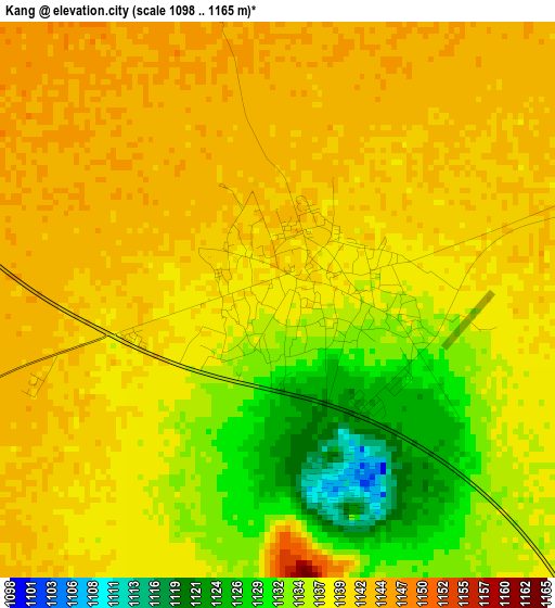
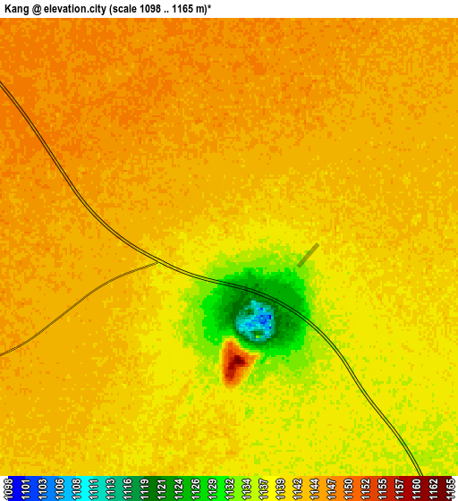
Below is the Elevation map of Kang, which displays elevation range with different colors. Scale of the first map is from 1098 to 1165 m (3602 to 3822 ft) with average elevation of 1138.2 meters (=3734 ft) [note 1]
These maps also provides idea of topography and contour of this city, they are displayed at different zoom levels. More info about maps, scale and edge coordinates you can find below images.
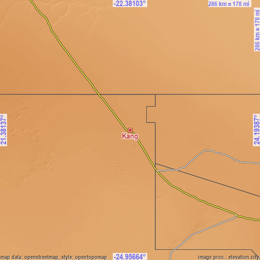
| \ | Map #1 | Map #2 | Topo.Map |
| Scale [m] | 1098..1165 m | 1098..1165 m | × |
| Scale [ft] | 3602..3822 ft | 3602..3822 ft | × |
| Average | 1138.2 m = 3734 ft | 1141.4 m = 3745 ft | × |
| Width | 8.95 km = 5.6 mi | 17.9 km = 11.1 mi | 286.4 km = 178 mi |
| Height | 8.95 km = 5.6 mi | 17.9 km = 11.1 mi | 286.4 km = 178 mi |
| ↑Max Latitude | -23.634927° | -23.594662° | -22.38103° |
| Latitude at center | -23.67518° | -23.67518° | -23.67518° |
| ↓Min Latitude | -23.715421° | -23.755649° | -24.95664° |
| ← Min Longitude | 22.743675° | 22.699729° | 21.38137° |
| Longitude center | 22.78762° | 22.78762° | 22.78762° |
| →Max Longitude | 22.831565° | 22.875511° | 24.19387° |
Nearby cities:
Cities around Kang sort by population:
• Ghanzi elevation 1144 m
249.1 km,  331°
331°
• Letlhakeng 1075 m
232.7 km,  101°
101°
• Hukuntsi 1141 m
108.6 km,  250°
250°
• Manyana 1191 m
113.4 km,  285°
285°
• Werda 1034 m
183.9 km,  164°
164°
• Khakhea 1055 m
133.6 km,  147°
147°
• Khudumelapye 1100 m
201 km, 96°
• Lehututu 1133 m
99.1 km, 250°
• Lokwabe 1120 m
111.3 km,  240°
240°
• Dutlwe 1109 m
118.2 km,  106°
106°
• Sekoma 1096 m
137.4 km,  125°
125°
• Jwaneng 1198 m
222.2 km,  117°
117°
Multilingual:
 En español:
Kang elevación 1139 m.
 En France:
Kang élévation 1139 m.


Sources and notes:
- [note 1] Map square and city borders are not equal. Map elevation data is calculated only from area inside that square.
- [src 1] Elevation data from geonames database provided with same terms of usage.
- [src 2] The elevation map of Kang is generated using elevation data from NASA's 3 arcsec (90m) resolution SRTM data.
- [src 3] Base (background) map © OpenStreetMap contributors tiles are generated by Geofabrik and OpenTopoMap.
Copyright & License:
This Kang Elevation Map is licensed under CC BY-SA. You may reuse any part from this page, if you give a proper credit by linking to this URL:
 More info on terms of use page.