Maun elevation
Maun (North-West), Botswana elevation is 947 meters and Maun elevation in feet is 3107 ft above sea level [src 1]. Maun is a seat of a first-order administrative division (feature code) with elevation that is 65 meters (213 ft) smaller than average city elevation in Botswana.
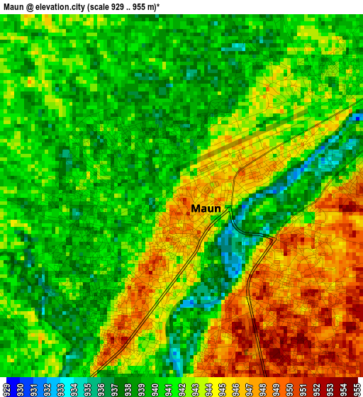
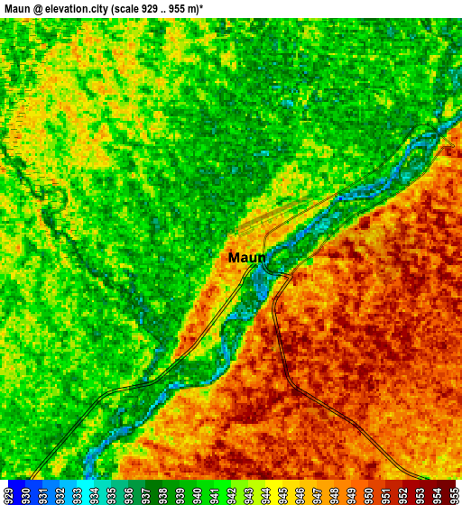
Below is the Elevation map of Maun, which displays elevation range with different colors. Scale of the first map is from 929 to 955 m (3048 to 3133 ft) with average elevation of 941.8 meters (=3090 ft) [note 1]
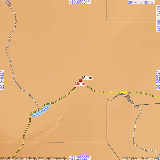
These maps also provides idea of topography and contour of this city, they are displayed at different zoom levels. More info about maps, scale and edge coordinates you can find below images.
| \ | Map #1 | Map #2 | Topo.Map |
| Scale [m] | 929..955 m | 929..955 m | × |
| Scale [ft] | 3048..3133 ft | 3048..3133 ft | × |
| Average | 941.8 m = 3090 ft | 943.1 m = 3094 ft | × |
| Width | 9.18 km = 5.7 mi | 18.37 km = 11.4 mi | 293.9 km = 182.6 mi |
| Height | 9.18 km = 5.7 mi | 18.37 km = 11.4 mi | 293.9 km = 182.6 mi |
| ↑Max Latitude | -19.942025° | -19.900709° | -18.65631° |
| Latitude at center | -19.98333° | -19.98333° | -19.98333° |
| ↓Min Latitude | -20.024624° | -20.065907° | -21.29927° |
| ← Min Longitude | 23.372725° | 23.328779° | 22.01042° |
| Longitude center | 23.41667° | 23.41667° | 23.41667° |
| →Max Longitude | 23.460615° | 23.504561° | 24.82292° |
Nearby cities:
Cities around Maun sort by population:
• Letlhakane elevation 984 m
276.7 km,  125°
125°
• Ghanzi 1144 m
265 km,  223°
223°
• Orapa 965 m
251.8 km, 125°
• Shakawe 1000 m
244.3 km,  317°
317°
• Rakops 918 m
151.7 km,  139°
139°
• Gweta 929 m
191 km,  96°
96°
• Mopipi 906 m
202.8 km, 131°
• Nokaneng 957 m
125.3 km,  286°
286°
• Pandamatenga 1072 m
282.9 km,  55°
55°
• Sehithwa 931 m
90.7 km,  233°
233°
• Tsau 945 m
102.6 km,  259°
259°
• Dekar 1139 m
231.3 km, 221°
Multilingual:
 En español:
Maun elevación 947 m.
 En France:
Maun élévation 947 m.


Sources and notes:
- [note 1] Map square and city borders are not equal. Map elevation data is calculated only from area inside that square.
- [src 1] Elevation data from geonames database provided with same terms of usage.
- [src 2] The elevation map of Maun is generated using elevation data from NASA's 3 arcsec (90m) resolution SRTM data.
- [src 3] Base (background) map © OpenStreetMap contributors tiles are generated by Geofabrik and OpenTopoMap.
Copyright & License:
This Maun Elevation Map is licensed under CC BY-SA. You may reuse any part from this page, if you give a proper credit by linking to this URL:
 More info on terms of use page.