Kasane elevation
Kasane (Chobe), Botswana elevation is 684 meters and Kasane elevation in feet is 2244 ft above sea level [src 1]. Kasane is a seat of a first-order administrative division (feature code) with elevation that is 328 meters (1076 ft) smaller than average city elevation in Botswana.
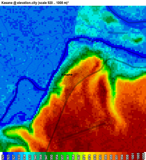
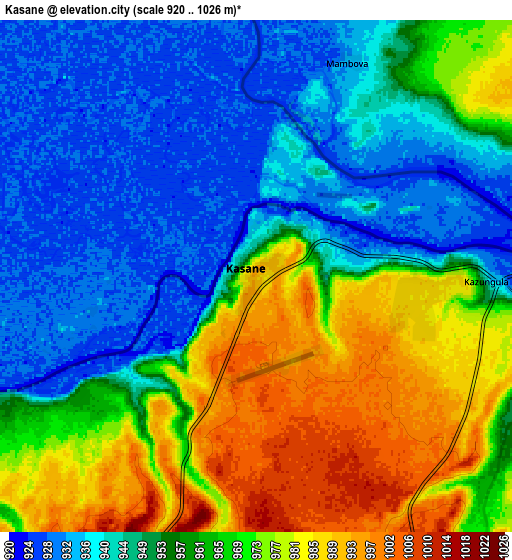
Below is the Elevation map of Kasane, which displays elevation range with different colors. Scale of the first map is from 920 to 1008 m (3018 to 3307 ft) with average elevation of 956.4 meters (=3138 ft) [note 1]
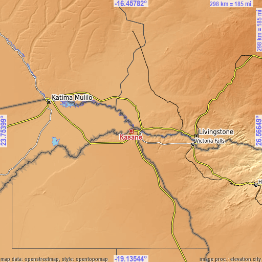
These maps also provides idea of topography and contour of this city, they are displayed at different zoom levels. More info about maps, scale and edge coordinates you can find below images.
| \ | Map #1 | Map #2 | Topo.Map |
| Scale [m] | 920..1008 m | 920..1026 m | × |
| Scale [ft] | 3018..3307 ft | 3018..3366 ft | × |
| Average | 956.4 m = 3138 ft | 958.1 m = 3143 ft | × |
| Width | 9.3 km = 5.8 mi | 18.61 km = 11.6 mi | 297.7 km = 185 mi |
| Height | 9.3 km = 5.8 mi | 18.61 km = 11.6 mi | 297.7 km = 185 mi |
| ↑Max Latitude | -17.759804° | -17.717948° | -16.45782° |
| Latitude at center | -17.80165° | -17.80165° | -17.80165° |
| ↓Min Latitude | -17.843486° | -17.885313° | -19.13544° |
| ← Min Longitude | 25.116295° | 25.072349° | 23.75399° |
| Longitude center | 25.16024° | 25.16024° | 25.16024° |
| →Max Longitude | 25.204185° | 25.248131° | 26.56649° |
Nearby cities:
Cities around Kasane sort by population:
• Maun elevation 947 m
304.1 km,  217°
217°
• Shakawe 1000 m
356.3 km,  259°
259°
• Rakops 918 m
367.8 km,  193°
193°
• Nata 912 m
289.3 km,  158°
158°
• Gweta 929 m
264.9 km,  178°
178°
• Mopipi 906 m
377.1 km, 184°
• Sua 929 m
272.9 km, 156°
• Dukwe 961 m
336.3 km, 156°
• Mosetse 1034 m
363.2 km,  154°
154°
• Nokaneng 957 m
368.5 km,  235°
235°
• Pandamatenga 1072 m
94.6 km, 148°
• Tsau 945 m
386.5 km,  227°
227°
Multilingual:
 En español:
Kasane elevación 684 m.
 En France:
Kasane élévation 684 m.


Sources and notes:
- [note 1] Map square and city borders are not equal. Map elevation data is calculated only from area inside that square.
- [src 1] Elevation data from geonames database provided with same terms of usage.
- [src 2] The elevation map of Kasane is generated using elevation data from NASA's 3 arcsec (90m) resolution SRTM data.
- [src 3] Base (background) map © OpenStreetMap contributors tiles are generated by Geofabrik and OpenTopoMap.
Copyright & License:
This Kasane Elevation Map is licensed under CC BY-SA. You may reuse any part from this page, if you give a proper credit by linking to this URL:
 More info on terms of use page.