Mookane elevation
Mookane (Central), Botswana elevation is 957 meters and Mookane elevation in feet is 3140 ft above sea level [src 1]. Mookane is a populated place (feature code) with elevation that is 55 meters (180 ft) smaller than average city elevation in Botswana.
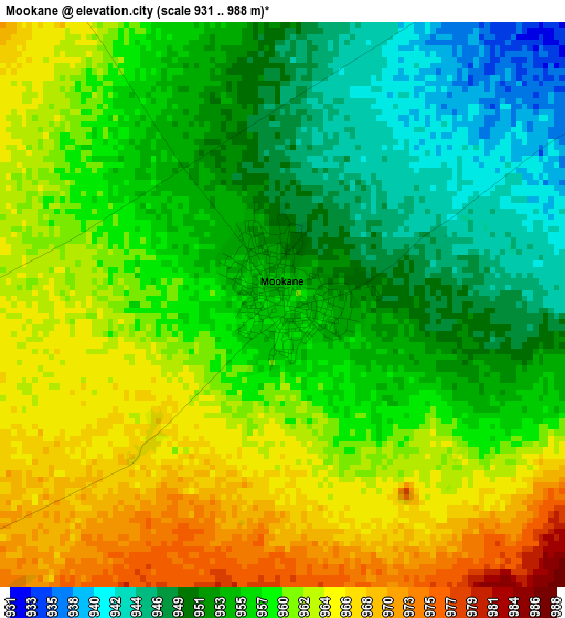
Below is the Elevation map of Mookane, which displays elevation range with different colors. Scale of the first map is from 931 to 988 m (3054 to 3241 ft) with average elevation of 957.4 meters (=3141 ft) [note 1]
These maps also provides idea of topography and contour of this city, they are displayed at different zoom levels. More info about maps, scale and edge coordinates you can find below images.
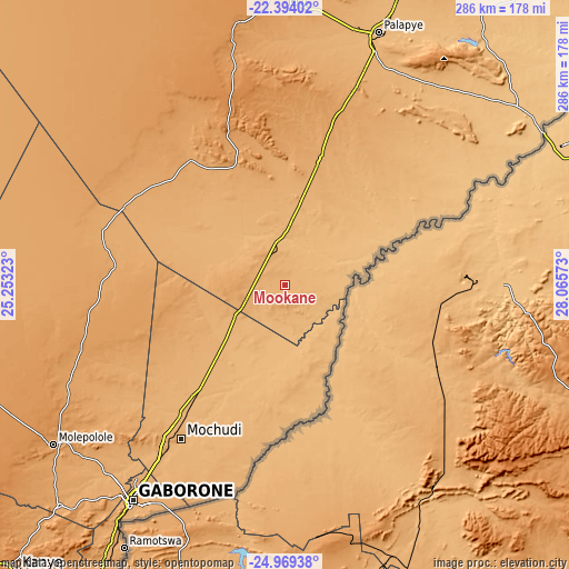
| \ | Map #1 | Topo.Map |
| Scale [m] | 931..988 m | × |
| Scale [ft] | 3054..3241 ft | × |
| Average | 957.4 m = 3141 ft | × |
| Width | 8.95 km = 5.6 mi | 286.4 km = 178 mi |
| Height | 8.95 km = 5.6 mi | 286.4 km = 178 mi |
| ↑Max Latitude | -23.647801° | -22.39402° |
| Latitude at center | -23.68805° | -23.68805° |
| ↓Min Latitude | -23.728287° | -24.96938° |
| ← Min Longitude | 26.615535° | 25.25323° |
| Longitude center | 26.65948° | 26.65948° |
| →Max Longitude | 26.703425° | 28.06573° |
Nearby cities:
Cities around Mookane sort by population:
• Mahalapye elevation 1025 m
66.8 km,  13°
13°
• Mochudi 952 m
96.1 km,  212°
212°
• Lenchwe Le Tau 1107 m
112.8 km,  226°
226°
• Bokaa 962 m
106.9 km,  217°
217°
• Kalamare 1182 m
84.4 km,  353°
353°
• Mmathubudukwane 930 m
104 km,  192°
192°
• Machaneng 844 m
101.3 km,  56°
56°
• Makwata 888 m
79.3 km, 55°
• Kurametsi 879 m
52.4 km,  52°
52°
• Pilane 957 m
100.2 km, 212°
• Magothla 860 m
37.2 km,  68°
68°
• Makoba 848 m
51.9 km, 63°
Multilingual:
 En español:
Mookane elevación 957 m.
 En France:
Mookane élévation 957 m.


Sources and notes:
- [note 1] Map square and city borders are not equal. Map elevation data is calculated only from area inside that square.
- [src 1] Elevation data from geonames database provided with same terms of usage.
- [src 2] The elevation map of Mookane is generated using elevation data from NASA's 3 arcsec (90m) resolution SRTM data.
- [src 3] Base (background) map © OpenStreetMap contributors tiles are generated by Geofabrik and OpenTopoMap.
Copyright & License:
This Mookane Elevation Map is licensed under CC BY-SA. You may reuse any part from this page, if you give a proper credit by linking to this URL:
 More info on terms of use page.