Mochudi elevation
Mochudi (Kgatleng), Botswana elevation is 952 meters and Mochudi elevation in feet is 3123 ft above sea level [src 1]. Mochudi is a seat of a first-order administrative division (feature code) with elevation that is 60 meters (197 ft) smaller than average city elevation in Botswana.
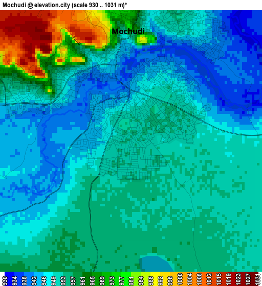
Below is the Elevation map of Mochudi, which displays elevation range with different colors. Scale of the first map is from 930 to 1031 m (3051 to 3383 ft) with average elevation of 953.7 meters (=3129 ft) [note 1]
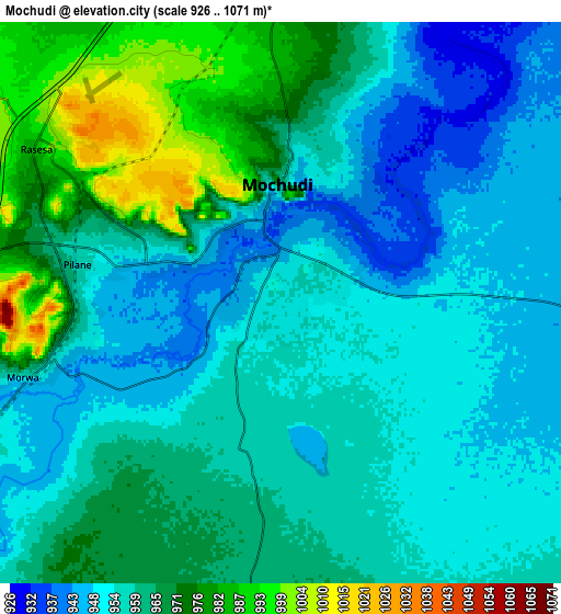
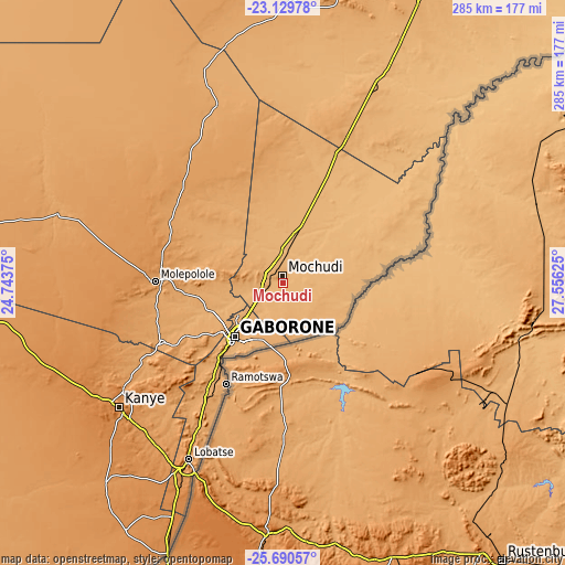
These maps also provides idea of topography and contour of this city, they are displayed at different zoom levels. More info about maps, scale and edge coordinates you can find below images.
| \ | Map #1 | Map #2 | Topo.Map |
| Scale [m] | 930..1031 m | 926..1071 m | × |
| Scale [ft] | 3051..3383 ft | 3038..3514 ft | × |
| Average | 953.7 m = 3129 ft | 960.4 m = 3151 ft | × |
| Width | 8.9 km = 5.5 mi | 17.8 km = 11.1 mi | 284.7 km = 176.9 mi |
| Height | 8.9 km = 5.5 mi | 17.8 km = 11.1 mi | 284.7 km = 176.9 mi |
| ↑Max Latitude | -24.376649° | -24.336615° | -23.12978° |
| Latitude at center | -24.41667° | -24.41667° | -24.41667° |
| ↓Min Latitude | -24.456679° | -24.496675° | -25.69057° |
| ← Min Longitude | 26.106055° | 26.062109° | 24.74375° |
| Longitude center | 26.15° | 26.15° | 26.15° |
| →Max Longitude | 26.193945° | 26.237891° | 27.55625° |
Nearby cities:
Cities around Mochudi sort by population:
• Gaborone elevation 1011 m
36 km,  222°
222°
• Mogoditshane 1026 m
37.1 km,  230°
230°
• Gabane 1090 m
46.4 km, 233°
• Kopong 984 m
28 km,  254°
254°
• Metsemotlhaba 996 m
38.2 km, 246°
• Lenchwe Le Tau 1107 m
30.6 km,  276°
276°
• Mmopone 1009 m
32.5 km,  239°
239°
• Bokaa 962 m
14 km, 254°
• Mmathubudukwane 930 m
35.2 km,  125°
125°
• Gaphatshwe 1010 m
36.4 km, 241°
• Nkoyaphiri 1053 m
40.2 km, 233°
• Pilane 957 m
4.1 km,  204°
204°
Multilingual:
 En español:
Mochudi elevación 952 m.
 En France:
Mochudi élévation 952 m.


Sources and notes:
- [note 1] Map square and city borders are not equal. Map elevation data is calculated only from area inside that square.
- [src 1] Elevation data from geonames database provided with same terms of usage.
- [src 2] The elevation map of Mochudi is generated using elevation data from NASA's 3 arcsec (90m) resolution SRTM data.
- [src 3] Base (background) map © OpenStreetMap contributors tiles are generated by Geofabrik and OpenTopoMap.
Copyright & License:
This Mochudi Elevation Map is licensed under CC BY-SA. You may reuse any part from this page, if you give a proper credit by linking to this URL:
 More info on terms of use page.