Amargosa elevation
Amargosa (Bahia), Brazil elevation is 412 meters and Amargosa elevation in feet is 1352 ft above sea level [src 1]. Amargosa is a populated place (feature code) with elevation that is 30 meters (98 ft) bigger than average city elevation in Brazil.
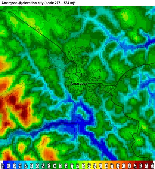
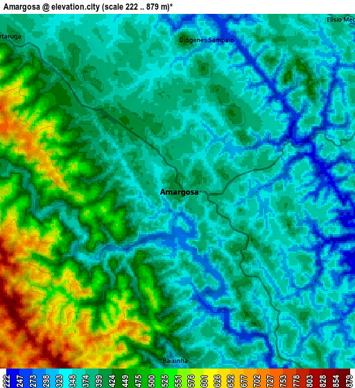
Below is the Elevation map of Amargosa, which displays elevation range with different colors. Scale of the first map is from 277 to 564 m (909 to 1850 ft) with average elevation of 376.8 meters (=1236 ft) [note 1]
These maps also provides idea of topography and contour of this city, they are displayed at different zoom levels. More info about maps, scale and edge coordinates you can find below images.
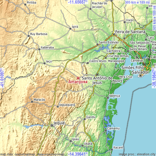
| \ | Map #1 | Map #2 | Topo.Map |
| Scale [m] | 277..564 m | 222..879 m | × |
| Scale [ft] | 909..1850 ft | 728..2884 ft | × |
| Average | 376.8 m = 1236 ft | 411 m = 1348 ft | × |
| Width | 9.52 km = 5.9 mi | 19.04 km = 11.8 mi | 304.6 km = 189.3 mi |
| Height | 9.52 km = 5.9 mi | 19.04 km = 11.8 mi | 304.7 km = 189.3 mi |
| ↑Max Latitude | -12.987463° | -12.944638° | -11.65657° |
| Latitude at center | -13.03028° | -13.03028° | -13.03028° |
| ↓Min Latitude | -13.07309° | -13.115893° | -14.39641° |
| ← Min Longitude | -39.648665° | -39.692611° | -41.01097° |
| Longitude center | -39.60472° | -39.60472° | -39.60472° |
| →Max Longitude | -39.560775° | -39.516829° | -38.19847° |
Nearby cities:
Cities around Amargosa sort by population:
• Santo Antônio de Jesus elevation 214 m
37.8 km,  79°
79°
• Valença 9 m
68.9 km,  123°
123°
• Cruz das Almas 224 m
67.6 km,  53°
53°
• Jaguaquara 675 m
68.3 km,  215°
215°
• Nazaré 12 m
63.9 km,  90°
90°
• Muritiba 219 m
40.5 km,  71°
71°
• Sobradinho 167 m
58.9 km, 68°
• Castro Alves 255 m
35.1 km,  33°
33°
• Santa Inês 400 m
37.2 km, 218°
• Mutuípe 219 m
24.6 km,  153°
153°
• Conceição do Almeida 219 m
54.8 km,  59°
59°
• Ubaíra 339 m
27.2 km,  193°
193°
Multilingual:
 En español:
Amargosa elevación 412 m.
 En France:
Amargosa élévation 412 m.
 Auf Deutsch:
Amargosa höhe über dem Meeresspiegel ist 412 m.

Sources and notes:
- [note 1] Map square and city borders are not equal. Map elevation data is calculated only from area inside that square.
- [src 1] Elevation data from geonames database provided with same terms of usage.
- [src 2] The elevation map of Amargosa is generated using elevation data from NASA's 3 arcsec (90m) resolution SRTM data.
- [src 3] Base (background) map © OpenStreetMap contributors tiles are generated by Geofabrik and OpenTopoMap.
Copyright & License:
This Amargosa Elevation Map is licensed under CC BY-SA. You may reuse any part from this page, if you give a proper credit by linking to this URL:
 More info on terms of use page.