Araçuaí elevation
Araçuaí (Minas Gerais), Brazil elevation is 316 meters and Araçuaí elevation in feet is 1037 ft above sea level [src 1]. Araçuaí is a populated place (feature code) with elevation that is 66 meters (217 ft) smaller than average city elevation in Brazil.
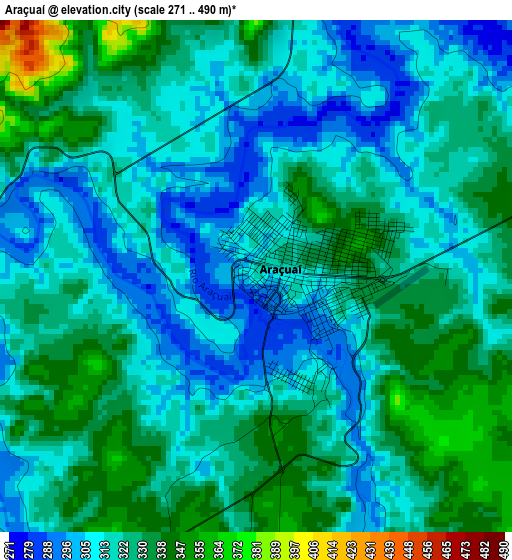
Below is the Elevation map of Araçuaí, which displays elevation range with different colors. Scale of the first map is from 271 to 490 m (889 to 1608 ft) with average elevation of 320.6 meters (=1052 ft) [note 1]
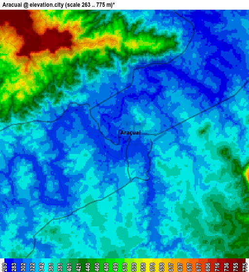
These maps also provides idea of topography and contour of this city, they are displayed at different zoom levels. More info about maps, scale and edge coordinates you can find below images.
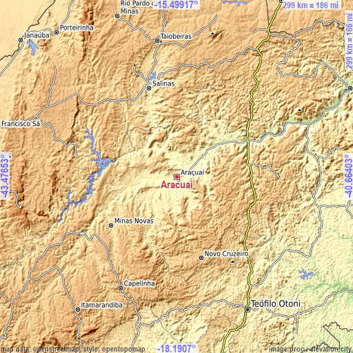
| \ | Map #1 | Map #2 | Topo.Map |
| Scale [m] | 271..490 m | 263..775 m | × |
| Scale [ft] | 889..1608 ft | 863..2543 ft | × |
| Average | 320.6 m = 1052 ft | 372.2 m = 1221 ft | × |
| Width | 9.35 km = 5.8 mi | 18.71 km = 11.6 mi | 299.3 km = 186 mi |
| Height | 9.35 km = 5.8 mi | 18.71 km = 11.6 mi | 299.3 km = 186 mi |
| ↑Max Latitude | -16.807657° | -16.765584° | -15.49917° |
| Latitude at center | -16.84972° | -16.84972° | -16.84972° |
| ↓Min Latitude | -16.891774° | -16.933819° | -18.1907° |
| ← Min Longitude | -42.114225° | -42.158171° | -43.47653° |
| Longitude center | -42.07028° | -42.07028° | -42.07028° |
| →Max Longitude | -42.026335° | -41.982389° | -40.66403° |
Nearby cities:
Cities around Araçuaí sort by population:
• Salinas elevation 472 m
79.1 km,  342°
342°
• Taiobeiras 832 m
117.1 km,  351°
351°
• Capelinha 926 m
104.9 km,  206°
206°
• Medina 572 m
94.1 km,  42°
42°
• Padre Paraíso 681 m
67.1 km,  111°
111°
• Novo Cruzeiro 770 m
71.8 km,  163°
163°
• Joaíma 270 m
112.8 km,  78°
78°
• Malacacheta 683 m
110.4 km,  180°
180°
• Turmalina 721 m
85.2 km,  235°
235°
• Minas Novas 558 m
68.8 km,  233°
233°
• Caraí 804 m
54.9 km,  133°
133°
• Itinga 268 m
41.8 km,  50°
50°
Multilingual:
 En español:
Araçuaí elevación 316 m.
 En France:
Araçuaí élévation 316 m.


Sources and notes:
- [note 1] Map square and city borders are not equal. Map elevation data is calculated only from area inside that square.
- [src 1] Elevation data from geonames database provided with same terms of usage.
- [src 2] The elevation map of Araçuaí is generated using elevation data from NASA's 3 arcsec (90m) resolution SRTM data.
- [src 3] Base (background) map © OpenStreetMap contributors tiles are generated by Geofabrik and OpenTopoMap.
Copyright & License:
This Araçuaí Elevation Map is licensed under CC BY-SA. You may reuse any part from this page, if you give a proper credit by linking to this URL:
 More info on terms of use page.