Bueno Brandão elevation
Bueno Brandão (Minas Gerais), Brazil elevation is 1184 meters and Bueno Brandão elevation in feet is 3885 ft above sea level [src 1]. Bueno Brandão is a populated place (feature code) with elevation that is 802 meters (2631 ft) bigger than average city elevation in Brazil.
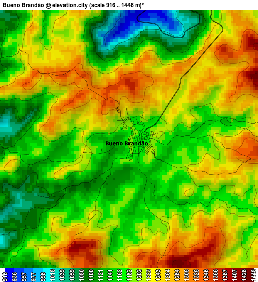
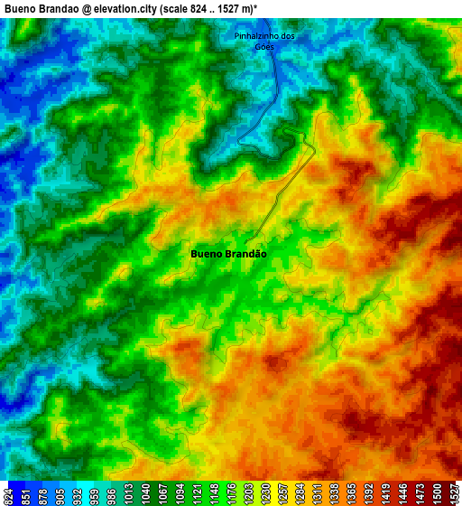
Below is the Elevation map of Bueno Brandão, which displays elevation range with different colors. Scale of the first map is from 916 to 1448 m (3005 to 4751 ft) with average elevation of 1199.2 meters (=3934 ft) [note 1]
These maps also provides idea of topography and contour of this city, they are displayed at different zoom levels. More info about maps, scale and edge coordinates you can find below images.
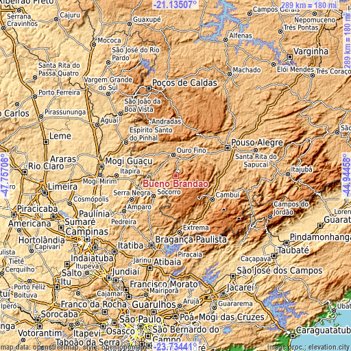
| \ | Map #1 | Map #2 | Topo.Map |
| Scale [m] | 916..1448 m | 824..1527 m | × |
| Scale [ft] | 3005..4751 ft | 2703..5010 ft | × |
| Average | 1199.2 m = 3934 ft | 1162.4 m = 3814 ft | × |
| Width | 9.03 km = 5.6 mi | 18.07 km = 11.2 mi | 289 km = 179.6 mi |
| Height | 9.03 km = 5.6 mi | 18.06 km = 11.2 mi | 289 km = 179.6 mi |
| ↑Max Latitude | -22.400207° | -22.359571° | -21.13507° |
| Latitude at center | -22.44083° | -22.44083° | -22.44083° |
| ↓Min Latitude | -22.481442° | -22.522041° | -23.73441° |
| ← Min Longitude | -46.394775° | -46.438721° | -47.75708° |
| Longitude center | -46.35083° | -46.35083° | -46.35083° |
| →Max Longitude | -46.306885° | -46.262939° | -44.94458° |
Nearby cities:
Cities around Bueno Brandão sort by population:
• Pouso Alegre elevation 838 m
48.6 km,  61°
61°
• Itapira 649 m
48.4 km,  270°
270°
• Andradas 905 m
47.1 km,  331°
331°
• Socorro 766 m
24.8 km,  227°
227°
• Serra Negra 937 m
40.7 km,  242°
242°
• Cambuí 896 m
35.6 km,  122°
122°
• Águas de Lindóia 901 m
29.2 km,  262°
262°
• Jacutinga 842 m
31.9 km,  302°
302°
• Camanducaia 1012 m
40.9 km,  148°
148°
• Extrema 946 m
46.1 km,  175°
175°
• Borda da Mata 895 m
26.6 km,  45°
45°
• Monte Sião 857 m
22.8 km, 272°
Multilingual:
 En español:
Bueno Brandão elevación 1184 m.
 En France:
Bueno Brandão élévation 1184 m.
 Auf Deutsch:
Bueno Brandão höhe über dem Meeresspiegel ist 1184 m.

Sources and notes:
- [note 1] Map square and city borders are not equal. Map elevation data is calculated only from area inside that square.
- [src 1] Elevation data from geonames database provided with same terms of usage.
- [src 2] The elevation map of Bueno Brandão is generated using elevation data from NASA's 3 arcsec (90m) resolution SRTM data.
- [src 3] Base (background) map © OpenStreetMap contributors tiles are generated by Geofabrik and OpenTopoMap.
Copyright & License:
This Bueno Brandão Elevation Map is licensed under CC BY-SA. You may reuse any part from this page, if you give a proper credit by linking to this URL:
 More info on terms of use page.