Pouso Alegre elevation
Pouso Alegre (Minas Gerais), Brazil elevation is 838 meters and Pouso Alegre elevation in feet is 2749 ft above sea level [src 1]. Pouso Alegre is a populated place (feature code) with elevation that is 456 meters (1496 ft) bigger than average city elevation in Brazil.
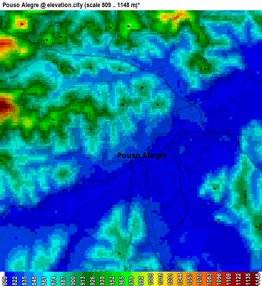
Below is the Elevation map of Pouso Alegre, which displays elevation range with different colors. Scale of the first map is from 809 to 1148 m (2654 to 3766 ft) with average elevation of 859.3 meters (=2819 ft) [note 1]
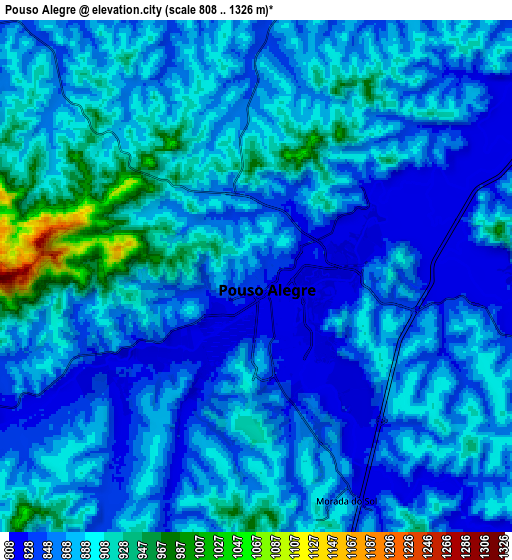
These maps also provides idea of topography and contour of this city, they are displayed at different zoom levels. More info about maps, scale and edge coordinates you can find below images.
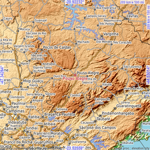
| \ | Map #1 | Map #2 | Topo.Map |
| Scale [m] | 809..1148 m | 808..1326 m | × |
| Scale [ft] | 2654..3766 ft | 2651..4350 ft | × |
| Average | 859.3 m = 2819 ft | 875.8 m = 2873 ft | × |
| Width | 9.05 km = 5.6 mi | 18.09 km = 11.2 mi | 289.5 km = 179.9 mi |
| Height | 9.05 km = 5.6 mi | 18.09 km = 11.2 mi | 289.5 km = 179.9 mi |
| ↑Max Latitude | -22.189315° | -22.148618° | -20.92232° |
| Latitude at center | -22.23° | -22.23° | -22.23° |
| ↓Min Latitude | -22.270673° | -22.311334° | -23.52559° |
| ← Min Longitude | -45.980335° | -46.024281° | -47.34264° |
| Longitude center | -45.93639° | -45.93639° | -45.93639° |
| →Max Longitude | -45.892445° | -45.848499° | -44.53014° |
Nearby cities:
Cities around Pouso Alegre sort by population:
• Itajubá elevation 858 m
54.3 km,  113°
113°
• Campos do Jordão 1603 m
66.8 km,  147°
147°
• Machado 815 m
61.8 km,  1°
1°
• Santa Rita do Sapucaí 826 m
24.1 km,  95°
95°
• Cambuí 896 m
44.3 km,  196°
196°
• São Gonçalo do Sapucaí 866 m
51.4 km,  43°
43°
• Camanducaia 1012 m
62.2 km, 200°
• Lambari 886 m
66.7 km,  64°
64°
• Paraisópolis 931 m
39.5 km,  155°
155°
• Borda da Mata 895 m
24.1 km,  258°
258°
• Campestre 1073 m
66 km,  331°
331°
• Bueno Brandão 1184 m
48.6 km,  241°
241°
Multilingual:
 En español:
Pouso Alegre elevación 838 m.
 En France:
Pouso Alegre élévation 838 m.
 Auf Deutsch:
Pouso Alegre höhe über dem Meeresspiegel ist 838 m.

Sources and notes:
- [note 1] Map square and city borders are not equal. Map elevation data is calculated only from area inside that square.
- [src 1] Elevation data from geonames database provided with same terms of usage.
- [src 2] The elevation map of Pouso Alegre is generated using elevation data from NASA's 3 arcsec (90m) resolution SRTM data.
- [src 3] Base (background) map © OpenStreetMap contributors tiles are generated by Geofabrik and OpenTopoMap.
Copyright & License:
This Pouso Alegre Elevation Map is licensed under CC BY-SA. You may reuse any part from this page, if you give a proper credit by linking to this URL:
 More info on terms of use page.