Canarana elevation
Canarana (Bahia), Brazil elevation is 696 meters and Canarana elevation in feet is 2283 ft above sea level [src 1]. Canarana is a populated place (feature code) with elevation that is 314 meters (1030 ft) bigger than average city elevation in Brazil.
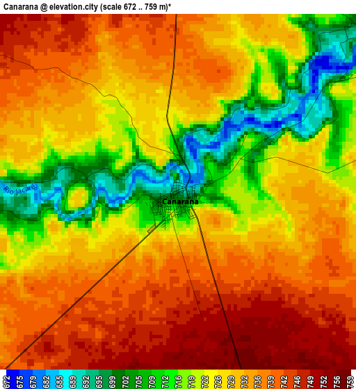
Below is the Elevation map of Canarana, which displays elevation range with different colors. Scale of the first map is from 672 to 759 m (2205 to 2490 ft) with average elevation of 728.1 meters (=2389 ft) [note 1]
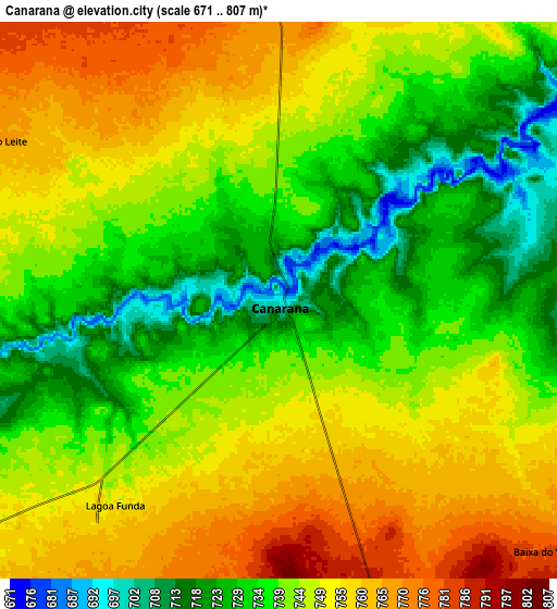
These maps also provides idea of topography and contour of this city, they are displayed at different zoom levels. More info about maps, scale and edge coordinates you can find below images.
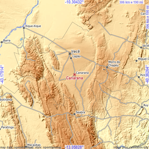
| \ | Map #1 | Map #2 | Topo.Map |
| Scale [m] | 672..759 m | 671..807 m | × |
| Scale [ft] | 2205..2490 ft | 2201..2648 ft | × |
| Average | 728.1 m = 2389 ft | 743.4 m = 2439 ft | × |
| Width | 9.57 km = 5.9 mi | 19.14 km = 11.9 mi | 306.2 km = 190.3 mi |
| Height | 9.57 km = 5.9 mi | 19.14 km = 11.9 mi | 306.2 km = 190.3 mi |
| ↑Max Latitude | -11.641682° | -11.598637° | -10.30432° |
| Latitude at center | -11.68472° | -11.68472° | -11.68472° |
| ↓Min Latitude | -11.727751° | -11.770776° | -13.05828° |
| ← Min Longitude | -41.812835° | -41.856781° | -43.17514° |
| Longitude center | -41.76889° | -41.76889° | -41.76889° |
| →Max Longitude | -41.724945° | -41.680999° | -40.36264° |
Nearby cities:
Cities around Canarana sort by population:
• Irecê elevation 730 m
43.4 km,  347°
347°
• Morro do Chapéu 1019 m
68.2 km,  77°
77°
• Seabra 823 m
81.4 km,  180°
180°
• Tapiramutá 825 m
107.9 km,  99°
99°
• Ibipeba 697 m
26.8 km,  280°
280°
• Barro Alto 701 m
17.7 km,  241°
241°
• América Dourada 665 m
44.3 km,  54°
54°
• Miguel Calmon 543 m
131 km, 77°
• Cafarnaum 763 m
32.7 km,  91°
91°
• Lapão 775 m
34.2 km, 348°
• Iraquara 699 m
64.8 km,  165°
165°
• Beira Rio 443 m
124.6 km, 239°
Multilingual:
 En español:
Canarana elevación 696 m.
 En France:
Canarana élévation 696 m.
 Auf Deutsch:
Canarana höhe über dem Meeresspiegel ist 696 m.

Sources and notes:
- [note 1] Map square and city borders are not equal. Map elevation data is calculated only from area inside that square.
- [src 1] Elevation data from geonames database provided with same terms of usage.
- [src 2] The elevation map of Canarana is generated using elevation data from NASA's 3 arcsec (90m) resolution SRTM data.
- [src 3] Base (background) map © OpenStreetMap contributors tiles are generated by Geofabrik and OpenTopoMap.
Copyright & License:
This Canarana Elevation Map is licensed under CC BY-SA. You may reuse any part from this page, if you give a proper credit by linking to this URL:
 More info on terms of use page.