Tapiramutá elevation
Tapiramutá (Bahia), Brazil elevation is 825 meters and Tapiramutá elevation in feet is 2707 ft above sea level [src 1]. Tapiramutá is a populated place (feature code) with elevation that is 443 meters (1453 ft) bigger than average city elevation in Brazil.
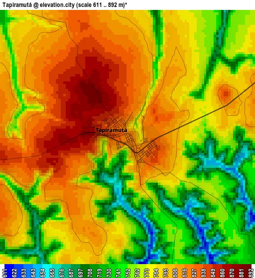
Below is the Elevation map of Tapiramutá, which displays elevation range with different colors. Scale of the first map is from 611 to 892 m (2005 to 2927 ft) with average elevation of 781.5 meters (=2564 ft) [note 1]
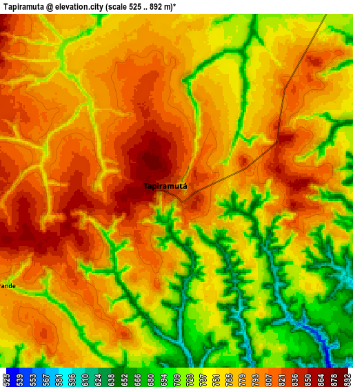
These maps also provides idea of topography and contour of this city, they are displayed at different zoom levels. More info about maps, scale and edge coordinates you can find below images.
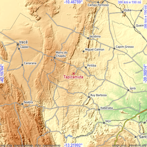
| \ | Map #1 | Map #2 | Topo.Map |
| Scale [m] | 611..892 m | 525..892 m | × |
| Scale [ft] | 2005..2927 ft | 1722..2927 ft | × |
| Average | 781.5 m = 2564 ft | 763.1 m = 2504 ft | × |
| Width | 9.56 km = 5.9 mi | 19.13 km = 11.9 mi | 306 km = 190.1 mi |
| Height | 9.56 km = 5.9 mi | 19.13 km = 11.9 mi | 306.1 km = 190.2 mi |
| ↑Max Latitude | -11.804207° | -11.761188° | -10.46759° |
| Latitude at center | -11.84722° | -11.84722° | -11.84722° |
| ↓Min Latitude | -11.890226° | -11.933225° | -13.21992° |
| ← Min Longitude | -40.835335° | -40.879281° | -42.19764° |
| Longitude center | -40.79139° | -40.79139° | -40.79139° |
| →Max Longitude | -40.747445° | -40.703499° | -39.38514° |
Nearby cities:
Cities around Tapiramutá sort by population:
• Jacobina elevation 476 m
80 km,  22°
22°
• Vera Cruz 533 m
91.3 km,  196°
196°
• Morro do Chapéu 1019 m
51.9 km,  309°
309°
• Ruy Barbosa 344 m
58.3 km,  146°
146°
• Piritiba 542 m
28.8 km,  63°
63°
• América Dourada 665 m
82.6 km,  301°
301°
• Miguel Calmon 543 m
51.2 km, 24°
• Mairi 471 m
71.5 km,  77°
77°
• Cafarnaum 763 m
75.6 km,  283°
283°
• Mundo Novo 522 m
34.7 km,  92°
92°
• Terra Nova 604 m
59.3 km,  166°
166°
• Baixa Grande 367 m
69 km,  100°
100°
Multilingual:
 En español:
Tapiramutá elevación 825 m.
 En France:
Tapiramutá élévation 825 m.
 Auf Deutsch:
Tapiramutá höhe über dem Meeresspiegel ist 825 m.

Sources and notes:
- [note 1] Map square and city borders are not equal. Map elevation data is calculated only from area inside that square.
- [src 1] Elevation data from geonames database provided with same terms of usage.
- [src 2] The elevation map of Tapiramutá is generated using elevation data from NASA's 3 arcsec (90m) resolution SRTM data.
- [src 3] Base (background) map © OpenStreetMap contributors tiles are generated by Geofabrik and OpenTopoMap.
Copyright & License:
This Tapiramutá Elevation Map is licensed under CC BY-SA. You may reuse any part from this page, if you give a proper credit by linking to this URL:
 More info on terms of use page.