Cascavel elevation
Cascavel (Paraná), Brazil elevation is 786 meters and Cascavel elevation in feet is 2579 ft above sea level [src 1]. Cascavel is a populated place (feature code) with elevation that is 404 meters (1325 ft) bigger than average city elevation in Brazil.
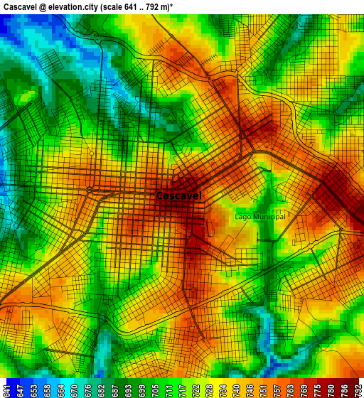
Below is the Elevation map of Cascavel, which displays elevation range with different colors. Scale of the first map is from 641 to 792 m (2103 to 2598 ft) with average elevation of 725 meters (=2379 ft) [note 1]
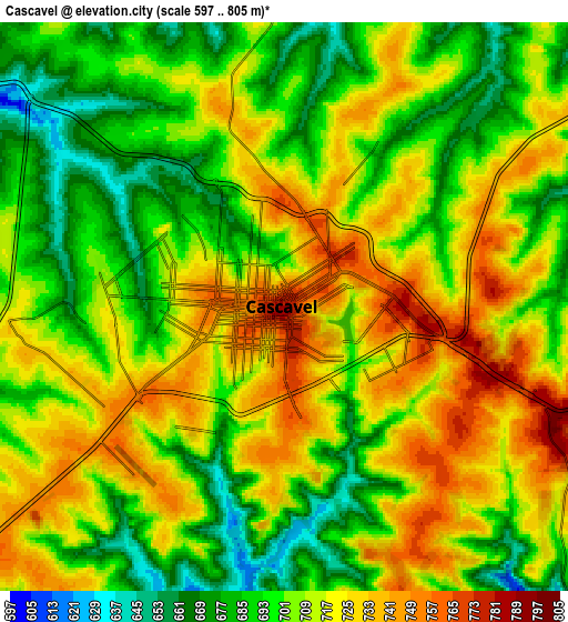
These maps also provides idea of topography and contour of this city, they are displayed at different zoom levels. More info about maps, scale and edge coordinates you can find below images.
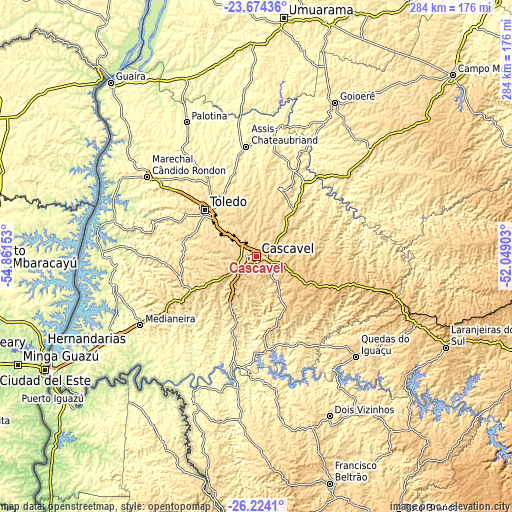
| \ | Map #1 | Map #2 | Topo.Map |
| Scale [m] | 641..792 m | 597..805 m | × |
| Scale [ft] | 2103..2598 ft | 1959..2641 ft | × |
| Average | 725 m = 2379 ft | 707.7 m = 2322 ft | × |
| Width | 8.86 km = 5.5 mi | 17.72 km = 11 mi | 283.5 km = 176.2 mi |
| Height | 8.86 km = 5.5 mi | 17.72 km = 11 mi | 283.5 km = 176.2 mi |
| ↑Max Latitude | -24.915981° | -24.87612° | -23.67436° |
| Latitude at center | -24.95583° | -24.95583° | -24.95583° |
| ↓Min Latitude | -24.995666° | -25.035489° | -26.2241° |
| ← Min Longitude | -53.499225° | -53.543171° | -54.86153° |
| Longitude center | -53.45528° | -53.45528° | -53.45528° |
| →Max Longitude | -53.411335° | -53.367389° | -52.04903° |
Nearby cities:
Cities around Cascavel sort by population:
• Toledo elevation 562 m
39.6 km,  312°
312°
• Marechal Cândido Rondon 425 m
75.3 km, 306°
• Medianeira 417 m
74.5 km,  239°
239°
• Palotina 339 m
84.2 km,  332°
332°
• Dois Vizinhos 562 m
95.3 km,  155°
155°
• São Miguel do Iguaçu 331 m
90 km, 241°
• Ampére 509 m
106.7 km,  180°
180°
• Corbélia 639 m
23 km,  40°
40°
• Matelândia 491 m
63 km, 239°
• Realeza 462 m
90.7 km, 184°
• Alto Piquiri 424 m
103.2 km,  0°
0°
• Guaraniaçu 819 m
60.3 km,  105°
105°
Multilingual:
 En español:
Cascavel elevación 786 m.
 En France:
Cascavel élévation 786 m.
 Auf Deutsch:
Cascavel höhe über dem Meeresspiegel ist 786 m.

Sources and notes:
- [note 1] Map square and city borders are not equal. Map elevation data is calculated only from area inside that square.
- [src 1] Elevation data from geonames database provided with same terms of usage.
- [src 2] The elevation map of Cascavel is generated using elevation data from NASA's 3 arcsec (90m) resolution SRTM data.
- [src 3] Base (background) map © OpenStreetMap contributors tiles are generated by Geofabrik and OpenTopoMap.
Copyright & License:
This Cascavel Elevation Map is licensed under CC BY-SA. You may reuse any part from this page, if you give a proper credit by linking to this URL:
 More info on terms of use page.