Coruripe elevation
Coruripe (Alagoas), Brazil elevation is 19 meters and Coruripe elevation in feet is 62 ft above sea level [src 1]. Coruripe is a populated place (feature code) with elevation that is 363 meters (1191 ft) smaller than average city elevation in Brazil.
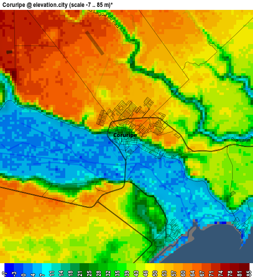
Below is the Elevation map of Coruripe, which displays elevation range with different colors. Scale of the first map is from -7 to 85 m (-23 to 279 ft) with average elevation of 40.3 meters (=132 ft) [note 1]
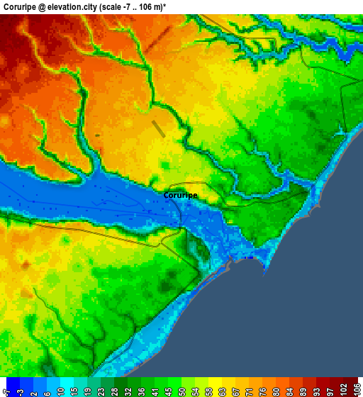
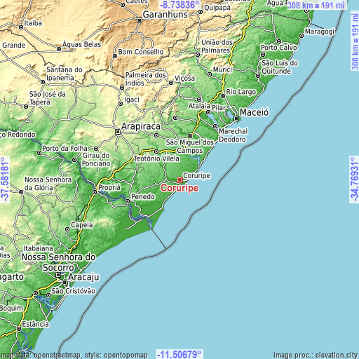
These maps also provides idea of topography and contour of this city, they are displayed at different zoom levels. More info about maps, scale and edge coordinates you can find below images.
| \ | Map #1 | Map #2 | Topo.Map |
| Scale [m] | -7..85 m | -7..106 m | × |
| Scale [ft] | -23..279 ft | -23..348 ft | × |
| Average | 40.3 m = 132 ft | 48.9 m = 160 ft | × |
| Width | 9.62 km = 6 mi | 19.24 km = 12 mi | 307.8 km = 191.3 mi |
| Height | 9.62 km = 6 mi | 19.24 km = 12 mi | 307.8 km = 191.3 mi |
| ↑Max Latitude | -10.082296° | -10.039027° | -8.73836° |
| Latitude at center | -10.12556° | -10.12556° | -10.12556° |
| ↓Min Latitude | -10.168818° | -10.21207° | -11.50679° |
| ← Min Longitude | -36.219505° | -36.263451° | -37.58181° |
| Longitude center | -36.17556° | -36.17556° | -36.17556° |
| →Max Longitude | -36.131615° | -36.087669° | -34.76931° |
Nearby cities:
Cities around Coruripe sort by population:
• Marechal Deodoro elevation 12 m
55.5 km,  33°
33°
• Penedo 12 m
48.5 km,  247°
247°
• São Miguel dos Campos 13 m
39.3 km,  13°
13°
• Campo Alegre 181 m
42.8 km,  333°
333°
• Cajueiro 215 m
54.5 km, 326°
• Neópolis 49 m
49.2 km,  243°
243°
• Piaçabuçu 6 m
42.1 km,  222°
222°
• Anadia 147 m
51 km,  343°
343°
• São Sebastião 204 m
46.6 km,  297°
297°
• Junqueiro 186 m
39.7 km, 304°
• Igreja Nova 34 m
53.2 km,  270°
270°
• Campo Grande 55 m
37.5 km, 251°
Multilingual:
 En español:
Coruripe elevación 19 m.
 En France:
Coruripe élévation 19 m.


Sources and notes:
- [note 1] Map square and city borders are not equal. Map elevation data is calculated only from area inside that square.
- [src 1] Elevation data from geonames database provided with same terms of usage.
- [src 2] The elevation map of Coruripe is generated using elevation data from NASA's 3 arcsec (90m) resolution SRTM data.
- [src 3] Base (background) map © OpenStreetMap contributors tiles are generated by Geofabrik and OpenTopoMap.
Copyright & License:
This Coruripe Elevation Map is licensed under CC BY-SA. You may reuse any part from this page, if you give a proper credit by linking to this URL:
 More info on terms of use page.