Curitibanos elevation
Curitibanos (Santa Catarina), Brazil elevation is 1002 meters and Curitibanos elevation in feet is 3287 ft above sea level [src 1]. Curitibanos is a populated place (feature code) with elevation that is 620 meters (2034 ft) bigger than average city elevation in Brazil.
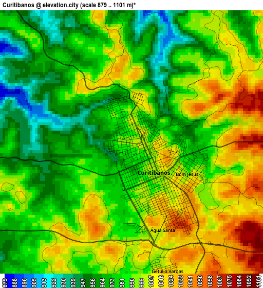
Below is the Elevation map of Curitibanos, which displays elevation range with different colors. Scale of the first map is from 879 to 1101 m (2884 to 3612 ft) with average elevation of 987.8 meters (=3241 ft) [note 1]
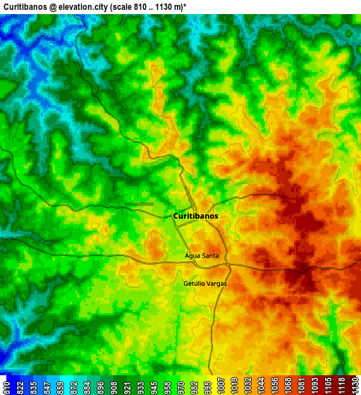
These maps also provides idea of topography and contour of this city, they are displayed at different zoom levels. More info about maps, scale and edge coordinates you can find below images.
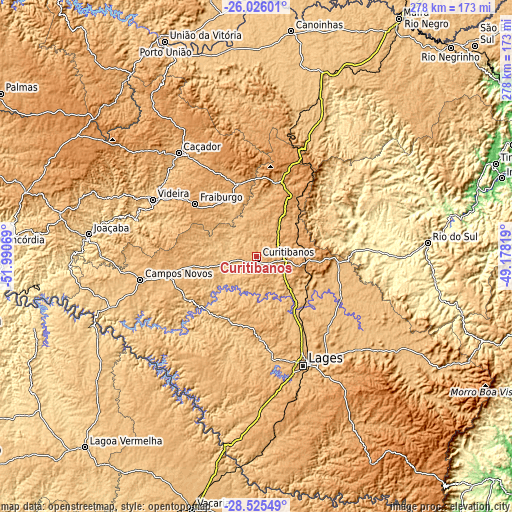
| \ | Map #1 | Map #2 | Topo.Map |
| Scale [m] | 879..1101 m | 810..1130 m | × |
| Scale [ft] | 2884..3612 ft | 2657..3707 ft | × |
| Average | 987.8 m = 3241 ft | 970.6 m = 3184 ft | × |
| Width | 8.69 km = 5.4 mi | 17.37 km = 10.8 mi | 277.9 km = 172.7 mi |
| Height | 8.69 km = 5.4 mi | 17.37 km = 10.8 mi | 277.9 km = 172.7 mi |
| ↑Max Latitude | -27.243717° | -27.204639° | -26.02601° |
| Latitude at center | -27.28278° | -27.28278° | -27.28278° |
| ↓Min Latitude | -27.32183° | -27.360866° | -28.52549° |
| ← Min Longitude | -50.628385° | -50.672331° | -51.99069° |
| Longitude center | -50.58444° | -50.58444° | -50.58444° |
| →Max Longitude | -50.540495° | -50.496549° | -49.17819° |
Nearby cities:
Cities around Curitibanos sort by population:
• Lages elevation 917 m
64.5 km,  156°
156°
• Caçador 916 m
70.7 km,  322°
322°
• Rio do Sul 346 m
93.4 km,  85°
85°
• Videira 747 m
63.9 km,  298°
298°
• Estrela 910 m
93.3 km,  201°
201°
• Capinzal 459 m
101.7 km,  266°
266°
• Joaçaba 551 m
91.7 km,  277°
277°
• Campos Novos 937 m
64.6 km,  258°
258°
• Celso Ramos 753 m
83.9 km,  242°
242°
• Santa Cecília 1097 m
39 km,  23°
23°
• Otacílio Costa 877 m
50.8 km,  115°
115°
• Correia Pinto 838 m
40.2 km,  146°
146°
Multilingual:
 En español:
Curitibanos elevación 1002 m.
 En France:
Curitibanos élévation 1002 m.
 Auf Deutsch:
Curitibanos höhe über dem Meeresspiegel ist 1002 m.

Sources and notes:
- [note 1] Map square and city borders are not equal. Map elevation data is calculated only from area inside that square.
- [src 1] Elevation data from geonames database provided with same terms of usage.
- [src 2] The elevation map of Curitibanos is generated using elevation data from NASA's 3 arcsec (90m) resolution SRTM data.
- [src 3] Base (background) map © OpenStreetMap contributors tiles are generated by Geofabrik and OpenTopoMap.
Copyright & License:
This Curitibanos Elevation Map is licensed under CC BY-SA. You may reuse any part from this page, if you give a proper credit by linking to this URL:
 More info on terms of use page.