Lages elevation
Lages (Santa Catarina), Brazil elevation is 917 meters and Lages elevation in feet is 3009 ft above sea level [src 1]. Lages is a populated place (feature code) with elevation that is 535 meters (1755 ft) bigger than average city elevation in Brazil.
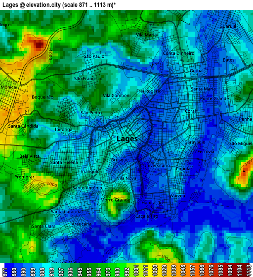
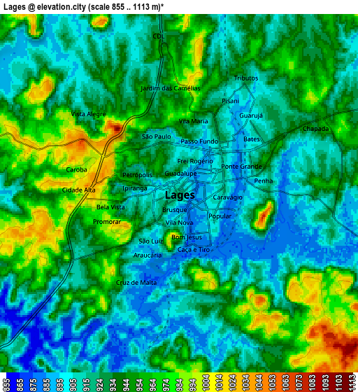
Below is the Elevation map of Lages, which displays elevation range with different colors. Scale of the first map is from 871 to 1113 m (2858 to 3652 ft) with average elevation of 925.5 meters (=3036 ft) [note 1]
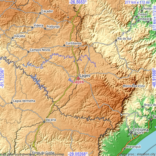
These maps also provides idea of topography and contour of this city, they are displayed at different zoom levels. More info about maps, scale and edge coordinates you can find below images.
| \ | Map #1 | Map #2 | Topo.Map |
| Scale [m] | 871..1113 m | 855..1113 m | × |
| Scale [ft] | 2858..3652 ft | 2805..3652 ft | × |
| Average | 925.5 m = 3036 ft | 934.4 m = 3066 ft | × |
| Width | 8.64 km = 5.4 mi | 17.29 km = 10.7 mi | 276.6 km = 171.9 mi |
| Height | 8.64 km = 5.4 mi | 17.29 km = 10.7 mi | 276.6 km = 171.9 mi |
| ↑Max Latitude | -27.777236° | -27.738347° | -26.5653° |
| Latitude at center | -27.81611° | -27.81611° | -27.81611° |
| ↓Min Latitude | -27.85497° | -27.893817° | -29.05268° |
| ← Min Longitude | -50.370055° | -50.414001° | -51.73236° |
| Longitude center | -50.32611° | -50.32611° | -50.32611° |
| →Max Longitude | -50.282165° | -50.238219° | -48.91986° |
Nearby cities:
Cities around Lages sort by population:
• Vacaria elevation 970 m
97.7 km,  217°
217°
• Rio do Sul 346 m
95 km,  45°
45°
• Curitibanos 1002 m
64.5 km,  336°
336°
• Estrela 910 m
66 km,  245°
245°
• Campos Novos 937 m
99.8 km,  297°
297°
• Ibirama 156 m
116.1 km,  43°
43°
• São Joaquim 1353 m
65.7 km,  143°
143°
• Celso Ramos 753 m
101.5 km,  281°
281°
• Santa Cecília 1097 m
95.6 km,  354°
354°
• Otacílio Costa 877 m
42.1 km,  28°
28°
• Correia Pinto 838 m
26 km, 352°
• Lauro Muller 218 m
111.4 km,  125°
125°
Multilingual:
 En español:
Lages elevación 917 m.
 En France:
Lages élévation 917 m.


Sources and notes:
- [note 1] Map square and city borders are not equal. Map elevation data is calculated only from area inside that square.
- [src 1] Elevation data from geonames database provided with same terms of usage.
- [src 2] The elevation map of Lages is generated using elevation data from NASA's 3 arcsec (90m) resolution SRTM data.
- [src 3] Base (background) map © OpenStreetMap contributors tiles are generated by Geofabrik and OpenTopoMap.
Copyright & License:
This Lages Elevation Map is licensed under CC BY-SA. You may reuse any part from this page, if you give a proper credit by linking to this URL:
 More info on terms of use page.