Edéia elevation
Edéia (Goiás), Brazil elevation is 579 meters and Edéia elevation in feet is 1900 ft above sea level [src 1]. Edéia is a populated place (feature code) with elevation that is 197 meters (646 ft) bigger than average city elevation in Brazil.
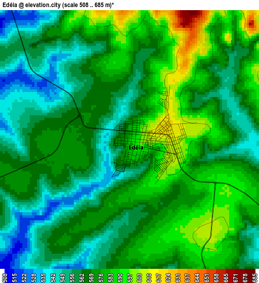
Below is the Elevation map of Edéia, which displays elevation range with different colors. Scale of the first map is from 508 to 685 m (1667 to 2247 ft) with average elevation of 569.6 meters (=1869 ft) [note 1]
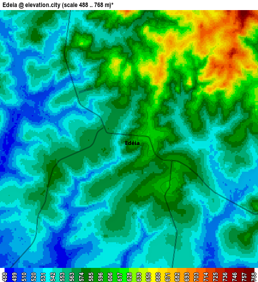
These maps also provides idea of topography and contour of this city, they are displayed at different zoom levels. More info about maps, scale and edge coordinates you can find below images.
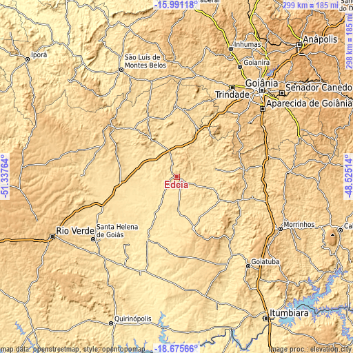
| \ | Map #1 | Map #2 | Topo.Map |
| Scale [m] | 508..685 m | 488..768 m | × |
| Scale [ft] | 1667..2247 ft | 1601..2520 ft | × |
| Average | 569.6 m = 1869 ft | 566.4 m = 1858 ft | × |
| Width | 9.33 km = 5.8 mi | 18.66 km = 11.6 mi | 298.5 km = 185.5 mi |
| Height | 9.33 km = 5.8 mi | 18.66 km = 11.6 mi | 298.5 km = 185.5 mi |
| ↑Max Latitude | -17.296377° | -17.254414° | -15.99118° |
| Latitude at center | -17.33833° | -17.33833° | -17.33833° |
| ↓Min Latitude | -17.380274° | -17.422208° | -18.67566° |
| ← Min Longitude | -49.975335° | -50.019281° | -51.33764° |
| Longitude center | -49.93139° | -49.93139° | -49.93139° |
| →Max Longitude | -49.887445° | -49.843499° | -48.52514° |
Nearby cities:
Cities around Edéia sort by population:
• Aparecida de Goiânia elevation 829 m
92.8 km,  51°
51°
• Trindade 768 m
89.9 km,  31°
31°
• Santa Helena de Goiás 566 m
88.1 km,  233°
233°
• Goiatuba 768 m
96.7 km,  140°
140°
• Piracanjuba 737 m
97.2 km,  87°
87°
• Anicuns 708 m
97.6 km,  358°
358°
• Pontalina 627 m
55.4 km,  112°
112°
• Palmeiras de Goiás 608 m
59.3 km,  0°
0°
• Guapó 710 m
70.6 km,  36°
36°
• Paraúna 679 m
70 km,  308°
308°
• Firminópolis 678 m
93 km,  334°
334°
• Hidrolândia 824 m
85.6 km,  60°
60°
Multilingual:
 En español:
Edéia elevación 579 m.
 En France:
Edéia élévation 579 m.


Sources and notes:
- [note 1] Map square and city borders are not equal. Map elevation data is calculated only from area inside that square.
- [src 1] Elevation data from geonames database provided with same terms of usage.
- [src 2] The elevation map of Edéia is generated using elevation data from NASA's 3 arcsec (90m) resolution SRTM data.
- [src 3] Base (background) map © OpenStreetMap contributors tiles are generated by Geofabrik and OpenTopoMap.
Copyright & License:
This Edéia Elevation Map is licensed under CC BY-SA. You may reuse any part from this page, if you give a proper credit by linking to this URL:
 More info on terms of use page.