Guapó elevation
Guapó (Goiás), Brazil elevation is 710 meters and Guapó elevation in feet is 2329 ft above sea level [src 1]. Guapó is a populated place (feature code) with elevation that is 328 meters (1076 ft) bigger than average city elevation in Brazil.
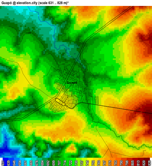
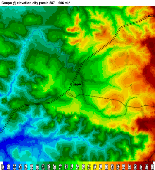
Below is the Elevation map of Guapó, which displays elevation range with different colors. Scale of the first map is from 631 to 828 m (2070 to 2717 ft) with average elevation of 729.3 meters (=2393 ft) [note 1]
These maps also provides idea of topography and contour of this city, they are displayed at different zoom levels. More info about maps, scale and edge coordinates you can find below images.
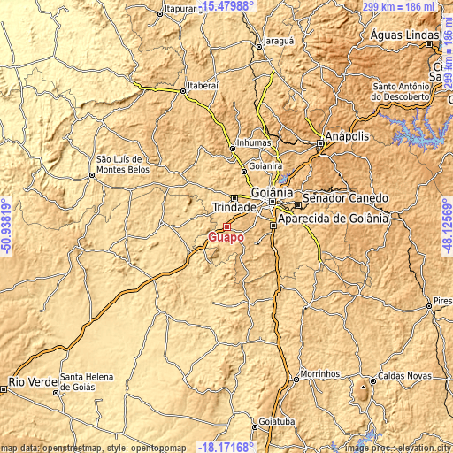
| \ | Map #1 | Map #2 | Topo.Map |
| Scale [m] | 631..828 m | 587..906 m | × |
| Scale [ft] | 2070..2717 ft | 1926..2972 ft | × |
| Average | 729.3 m = 2393 ft | 723.8 m = 2375 ft | × |
| Width | 9.35 km = 5.8 mi | 18.71 km = 11.6 mi | 299.3 km = 186 mi |
| Height | 9.35 km = 5.8 mi | 18.71 km = 11.6 mi | 299.3 km = 186 mi |
| ↑Max Latitude | -16.788492° | -16.746415° | -15.47988° |
| Latitude at center | -16.83056° | -16.83056° | -16.83056° |
| ↓Min Latitude | -16.872618° | -16.914667° | -18.17168° |
| ← Min Longitude | -49.575885° | -49.619831° | -50.93819° |
| Longitude center | -49.53194° | -49.53194° | -49.53194° |
| →Max Longitude | -49.487995° | -49.444049° | -48.12569° |
Nearby cities:
Cities around Guapó sort by population:
• Goiânia elevation 766 m
34.1 km,  60°
60°
• Aparecida de Goiânia 829 m
30.7 km,  88°
88°
• Trindade 768 m
20.7 km,  12°
12°
• Senador Canedo 800 m
48.7 km,  73°
73°
• Inhumas 763 m
52.7 km,  4°
4°
• Goianira 760 m
38.8 km,  16°
16°
• Nerópolis 822 m
57.8 km,  35°
35°
• Anicuns 708 m
61.5 km,  311°
311°
• Bela Vista de Goiás 803 m
63.6 km,  104°
104°
• Palmeiras de Goiás 608 m
42 km,  273°
273°
• Goianápolis 975 m
64.8 km, 56°
• Hidrolândia 824 m
35.5 km,  114°
114°
Multilingual:
 En español:
Guapó elevación 710 m.
 En France:
Guapó élévation 710 m.


Sources and notes:
- [note 1] Map square and city borders are not equal. Map elevation data is calculated only from area inside that square.
- [src 1] Elevation data from geonames database provided with same terms of usage.
- [src 2] The elevation map of Guapó is generated using elevation data from NASA's 3 arcsec (90m) resolution SRTM data.
- [src 3] Base (background) map © OpenStreetMap contributors tiles are generated by Geofabrik and OpenTopoMap.
Copyright & License:
This Guapó Elevation Map is licensed under CC BY-SA. You may reuse any part from this page, if you give a proper credit by linking to this URL:
 More info on terms of use page.