Entre Rios elevation
Entre Rios (Bahia), Brazil elevation is 165 meters and Entre Rios elevation in feet is 541 ft above sea level [src 1]. Entre Rios is a populated place (feature code) with elevation that is 217 meters (712 ft) smaller than average city elevation in Brazil.
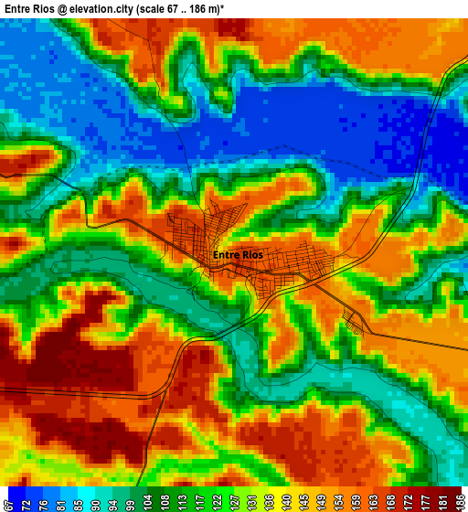
Below is the Elevation map of Entre Rios, which displays elevation range with different colors. Scale of the first map is from 67 to 186 m (220 to 610 ft) with average elevation of 125.6 meters (=412 ft) [note 1]
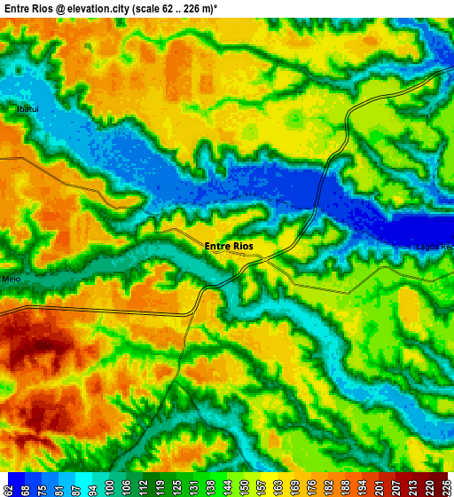
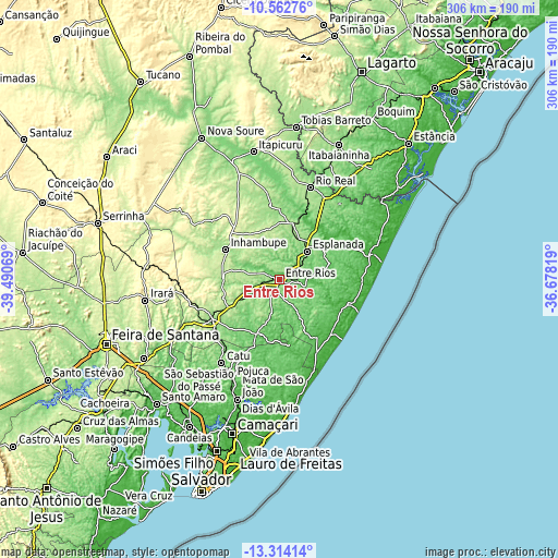
These maps also provides idea of topography and contour of this city, they are displayed at different zoom levels. More info about maps, scale and edge coordinates you can find below images.
| \ | Map #1 | Map #2 | Topo.Map |
| Scale [m] | 67..186 m | 62..226 m | × |
| Scale [ft] | 220..610 ft | 203..741 ft | × |
| Average | 125.6 m = 412 ft | 138.1 m = 453 ft | × |
| Width | 9.56 km = 5.9 mi | 19.12 km = 11.9 mi | 305.9 km = 190.1 mi |
| Height | 9.56 km = 5.9 mi | 19.12 km = 11.9 mi | 306 km = 190.1 mi |
| ↑Max Latitude | -11.898942° | -11.855938° | -10.56276° |
| Latitude at center | -11.94194° | -11.94194° | -11.94194° |
| ↓Min Latitude | -11.984931° | -12.027915° | -13.31414° |
| ← Min Longitude | -38.128385° | -38.172331° | -39.49069° |
| Longitude center | -38.08444° | -38.08444° | -38.08444° |
| →Max Longitude | -38.040495° | -37.996549° | -36.67819° |
Nearby cities:
Cities around Entre Rios sort by population:
• Alagoinhas elevation 158 m
42.3 km,  239°
239°
• Catu 79 m
55.8 km,  214°
214°
• Mata de São João 35 m
69.5 km,  199°
199°
• Rio Real 170 m
53.5 km,  17°
17°
• Esplanada 156 m
22.2 km,  43°
43°
• Conde 9 m
53.5 km,  74°
74°
• Inhambupe 169 m
34.1 km,  300°
300°
• Acajutiba 183 m
32 km,  13°
13°
• Olindina 166 m
69.5 km,  337°
337°
• Cristinápolis 153 m
63 km,  34°
34°
• Itapicuru 117 m
71.4 km,  346°
346°
• Tomar do Geru 194 m
68.6 km, 22°
Multilingual:
 En español:
Entre Rios elevación 165 m.
 En France:
Entre Rios élévation 165 m.
 Auf Deutsch:
Entre Rios höhe über dem Meeresspiegel ist 165 m.

Sources and notes:
- [note 1] Map square and city borders are not equal. Map elevation data is calculated only from area inside that square.
- [src 1] Elevation data from geonames database provided with same terms of usage.
- [src 2] The elevation map of Entre Rios is generated using elevation data from NASA's 3 arcsec (90m) resolution SRTM data.
- [src 3] Base (background) map © OpenStreetMap contributors tiles are generated by Geofabrik and OpenTopoMap.
Copyright & License:
This Entre Rios Elevation Map is licensed under CC BY-SA. You may reuse any part from this page, if you give a proper credit by linking to this URL:
 More info on terms of use page.