Cristinápolis elevation
Cristinápolis (Sergipe), Brazil elevation is 153 meters and Cristinápolis elevation in feet is 502 ft above sea level [src 1]. Cristinápolis is a populated place (feature code) with elevation that is 229 meters (751 ft) smaller than average city elevation in Brazil.
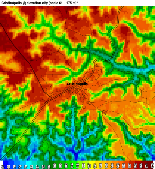
Below is the Elevation map of Cristinápolis, which displays elevation range with different colors. Scale of the first map is from 61 to 175 m (200 to 574 ft) with average elevation of 128.8 meters (=423 ft) [note 1]
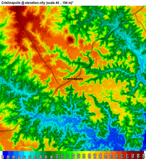
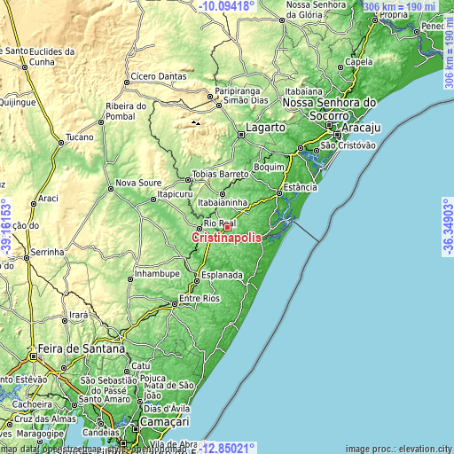
These maps also provides idea of topography and contour of this city, they are displayed at different zoom levels. More info about maps, scale and edge coordinates you can find below images.
| \ | Map #1 | Map #2 | Topo.Map |
| Scale [m] | 61..175 m | 44..194 m | × |
| Scale [ft] | 200..574 ft | 144..636 ft | × |
| Average | 128.8 m = 423 ft | 114.8 m = 377 ft | × |
| Width | 9.58 km = 6 mi | 19.15 km = 11.9 mi | 306.4 km = 190.4 mi |
| Height | 9.58 km = 6 mi | 19.15 km = 11.9 mi | 306.5 km = 190.4 mi |
| ↑Max Latitude | -11.43249° | -11.389413° | -10.09418° |
| Latitude at center | -11.47556° | -11.47556° | -11.47556° |
| ↓Min Latitude | -11.518624° | -11.56168° | -12.85021° |
| ← Min Longitude | -37.799225° | -37.843171° | -39.16153° |
| Longitude center | -37.75528° | -37.75528° | -37.75528° |
| →Max Longitude | -37.711335° | -37.667389° | -36.34903° |
Nearby cities:
Cities around Cristinápolis sort by population:
• Estância elevation 54 m
41.5 km,  56°
56°
• Tobias Barreto 164 m
41.9 km,  320°
320°
• Rio Real 170 m
19.4 km,  266°
266°
• Esplanada 156 m
41.2 km,  210°
210°
• Itabaianinha 223 m
22.7 km,  350°
350°
• Conde 9 m
40.8 km,  157°
157°
• Boquim 162 m
39.4 km,  21°
21°
• Acajutiba 183 m
35.3 km,  233°
233°
• Umbaúba 142 m
14.8 km,  46°
46°
• Indiaroba 7 m
27 km,  100°
100°
• Arauá 112 m
27.9 km,  31°
31°
• Tomar do Geru 194 m
14.7 km, 320°
Multilingual:
 En español:
Cristinápolis elevación 153 m.
 En France:
Cristinápolis élévation 153 m.
 Auf Deutsch:
Cristinápolis höhe über dem Meeresspiegel ist 153 m.

Sources and notes:
- [note 1] Map square and city borders are not equal. Map elevation data is calculated only from area inside that square.
- [src 1] Elevation data from geonames database provided with same terms of usage.
- [src 2] The elevation map of Cristinápolis is generated using elevation data from NASA's 3 arcsec (90m) resolution SRTM data.
- [src 3] Base (background) map © OpenStreetMap contributors tiles are generated by Geofabrik and OpenTopoMap.
Copyright & License:
This Cristinápolis Elevation Map is licensed under CC BY-SA. You may reuse any part from this page, if you give a proper credit by linking to this URL:
 More info on terms of use page.