Gravataí elevation
Gravataí (Rio Grande do Sul), Brazil elevation is 41 meters and Gravataí elevation in feet is 135 ft above sea level [src 1]. Gravataí is a seat of a second-order administrative division (feature code) with elevation that is 341 meters (1119 ft) smaller than average city elevation in Brazil.
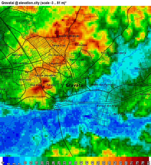
Below is the Elevation map of Gravataí, which displays elevation range with different colors. Scale of the first map is from -3 to 81 m (-10 to 266 ft) with average elevation of 28.9 meters (=95 ft) [note 1]
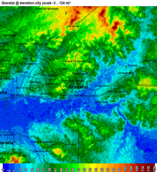
These maps also provides idea of topography and contour of this city, they are displayed at different zoom levels. More info about maps, scale and edge coordinates you can find below images.
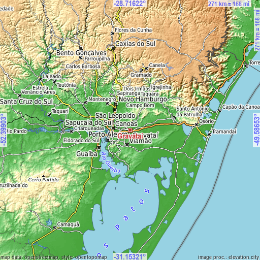
| \ | Map #1 | Map #2 | Topo.Map |
| Scale [m] | -3..81 m | -3..124 m | × |
| Scale [ft] | -10..266 ft | -10..407 ft | × |
| Average | 28.9 m = 95 ft | 34.6 m = 114 ft | × |
| Width | 8.47 km = 5.3 mi | 16.94 km = 10.5 mi | 271 km = 168.4 mi |
| Height | 8.47 km = 5.3 mi | 16.94 km = 10.5 mi | 271 km = 168.4 mi |
| ↑Max Latitude | -29.904093° | -29.865991° | -28.71622° |
| Latitude at center | -29.94218° | -29.94218° | -29.94218° |
| ↓Min Latitude | -29.980253° | -30.018311° | -31.15321° |
| ← Min Longitude | -51.036725° | -51.080671° | -52.39903° |
| Longitude center | -50.99278° | -50.99278° | -50.99278° |
| →Max Longitude | -50.948835° | -50.904889° | -49.58653° |
Nearby cities:
Cities around Gravataí sort by population:
• Porto Alegre elevation 1 m
25 km,  246°
246°
• Canoas 25 m
18.6 km,  278°
278°
• Viamão 108 m
15.7 km,  190°
190°
• Novo Hamburgo 56 m
32.2 km,  335°
335°
• São Leopoldo 10 m
25.1 km,  323°
323°
• Sapucaia 37 m
19.4 km,  308°
308°
• Cachoeirinha 15 m
9.8 km,  264°
264°
• Guaíba 22 m
37.2 km,  239°
239°
• Esteio 12 m
20.1 km,  296°
296°
• Sapiranga 36 m
33.8 km,  357°
357°
• Estância Velha 43 m
37.1 km,  331°
331°
• Portão 49 m
36 km, 318°
Multilingual:
 En español:
Gravataí elevación 41 m.
 En France:
Gravataí élévation 41 m.


Sources and notes:
- [note 1] Map square and city borders are not equal. Map elevation data is calculated only from area inside that square.
- [src 1] Elevation data from geonames database provided with same terms of usage.
- [src 2] The elevation map of Gravataí is generated using elevation data from NASA's 3 arcsec (90m) resolution SRTM data.
- [src 3] Base (background) map © OpenStreetMap contributors tiles are generated by Geofabrik and OpenTopoMap.
Copyright & License:
This Gravataí Elevation Map is licensed under CC BY-SA. You may reuse any part from this page, if you give a proper credit by linking to this URL:
 More info on terms of use page.