Guarulhos elevation
Guarulhos (São Paulo), Brazil elevation is 774 meters and Guarulhos elevation in feet is 2539 ft above sea level [src 1]. Guarulhos is a populated place (feature code) with elevation that is 392 meters (1286 ft) bigger than average city elevation in Brazil.
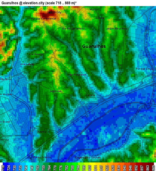
Below is the Elevation map of Guarulhos, which displays elevation range with different colors. Scale of the first map is from 718 to 869 m (2356 to 2851 ft) with average elevation of 757.1 meters (=2484 ft) [note 1]
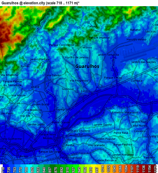
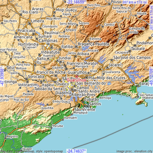
These maps also provides idea of topography and contour of this city, they are displayed at different zoom levels. More info about maps, scale and edge coordinates you can find below images.
| \ | Map #1 | Map #2 | Topo.Map |
| Scale [m] | 718..869 m | 718..1171 m | × |
| Scale [ft] | 2356..2851 ft | 2356..3842 ft | × |
| Average | 757.1 m = 2484 ft | 785 m = 2575 ft | × |
| Width | 8.96 km = 5.6 mi | 17.93 km = 11.1 mi | 286.8 km = 178.2 mi |
| Height | 8.96 km = 5.6 mi | 17.93 km = 11.1 mi | 286.9 km = 178.3 mi |
| ↑Max Latitude | -23.422462° | -23.382132° | -22.16659° |
| Latitude at center | -23.46278° | -23.46278° | -23.46278° |
| ↓Min Latitude | -23.503086° | -23.543379° | -24.74637° |
| ← Min Longitude | -46.577275° | -46.621221° | -47.93958° |
| Longitude center | -46.53333° | -46.53333° | -46.53333° |
| →Max Longitude | -46.489385° | -46.445439° | -45.12708° |
Nearby cities:
Cities around Guarulhos sort by population:
• São Paulo elevation 769 m
14.1 km,  228°
228°
• Santo André 801 m
22.4 km,  181°
181°
• Mauá 773 m
23.9 km,  162°
162°
• Itaquaquecetuba 748 m
19 km,  97°
97°
• Ferraz de Vasconcelos 759 m
18.9 km,  117°
117°
• São Caetano do Sul 770 m
17.9 km,  185°
185°
• Poá 764 m
20.6 km,  110°
110°
• Caieiras 793 m
23.8 km,  297°
297°
• Jardim Paulista 629 m
17.7 km, 229°
• Arujá 788 m
22.9 km,  71°
71°
• Mairiporã 752 m
16.9 km,  341°
341°
• Paraíso 633 m
17.3 km,  223°
223°
Multilingual:
 En español:
Guarulhos elevación 774 m.
 En France:
Guarulhos élévation 774 m.
 Auf Deutsch:
Guarulhos höhe über dem Meeresspiegel ist 774 m.

Sources and notes:
- [note 1] Map square and city borders are not equal. Map elevation data is calculated only from area inside that square.
- [src 1] Elevation data from geonames database provided with same terms of usage.
- [src 2] The elevation map of Guarulhos is generated using elevation data from NASA's 3 arcsec (90m) resolution SRTM data.
- [src 3] Base (background) map © OpenStreetMap contributors tiles are generated by Geofabrik and OpenTopoMap.
Copyright & License:
This Guarulhos Elevation Map is licensed under CC BY-SA. You may reuse any part from this page, if you give a proper credit by linking to this URL:
 More info on terms of use page.