Ibirubá elevation
Ibirubá (Rio Grande do Sul), Brazil elevation is 404 meters and Ibirubá elevation in feet is 1325 ft above sea level [src 1]. Ibirubá is a populated place (feature code) with elevation that is 22 meters (72 ft) bigger than average city elevation in Brazil.
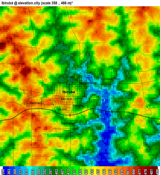
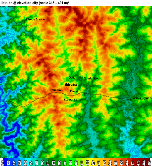
Below is the Elevation map of Ibirubá, which displays elevation range with different colors. Scale of the first map is from 358 to 486 m (1175 to 1594 ft) with average elevation of 422.6 meters (=1386 ft) [note 1]
These maps also provides idea of topography and contour of this city, they are displayed at different zoom levels. More info about maps, scale and edge coordinates you can find below images.
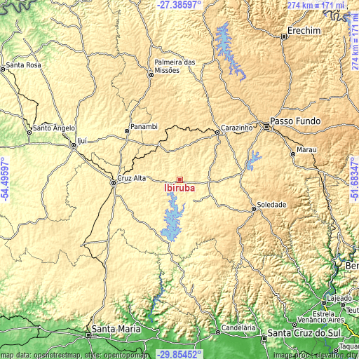
| \ | Map #1 | Map #2 | Topo.Map |
| Scale [m] | 358..486 m | 318..491 m | × |
| Scale [ft] | 1175..1594 ft | 1043..1611 ft | × |
| Average | 422.6 m = 1386 ft | 402.5 m = 1321 ft | × |
| Width | 8.58 km = 5.3 mi | 17.16 km = 10.7 mi | 274.5 km = 170.6 mi |
| Height | 8.58 km = 5.3 mi | 17.16 km = 10.7 mi | 274.5 km = 170.6 mi |
| ↑Max Latitude | -28.58892° | -28.550325° | -27.38597° |
| Latitude at center | -28.6275° | -28.6275° | -28.6275° |
| ↓Min Latitude | -28.666066° | -28.704618° | -29.85452° |
| ← Min Longitude | -53.133665° | -53.177611° | -54.49597° |
| Longitude center | -53.08972° | -53.08972° | -53.08972° |
| →Max Longitude | -53.045775° | -53.001829° | -51.68347° |
Nearby cities:
Cities around Ibirubá sort by population:
• Passo Fundo elevation 689 m
78.1 km,  58°
58°
• Ijuí 329 m
84.9 km,  288°
288°
• Cruz Alta 475 m
50.4 km,  267°
267°
• Carazinho 605 m
48.4 km,  37°
37°
• Palmeira das Missões 623 m
83.9 km,  344°
344°
• Panambi 421 m
54.9 km,  312°
312°
• Soledade 717 m
60.4 km,  110°
110°
• Júlio de Castilhos 518 m
88.1 km,  220°
220°
• Tupanciretã 464 m
88.4 km,  235°
235°
• Sarandi 505 m
77.7 km,  12°
12°
• Não Me Toque 524 m
32.3 km,  54°
54°
• Espumoso 366 m
25.8 km, 114°
Multilingual:
 En español:
Ibirubá elevación 404 m.
 En France:
Ibirubá élévation 404 m.


Sources and notes:
- [note 1] Map square and city borders are not equal. Map elevation data is calculated only from area inside that square.
- [src 1] Elevation data from geonames database provided with same terms of usage.
- [src 2] The elevation map of Ibirubá is generated using elevation data from NASA's 3 arcsec (90m) resolution SRTM data.
- [src 3] Base (background) map © OpenStreetMap contributors tiles are generated by Geofabrik and OpenTopoMap.
Copyright & License:
This Ibirubá Elevation Map is licensed under CC BY-SA. You may reuse any part from this page, if you give a proper credit by linking to this URL:
 More info on terms of use page.