Tupanciretã elevation
Tupanciretã (Rio Grande do Sul), Brazil elevation is 464 meters and Tupanciretã elevation in feet is 1522 ft above sea level [src 1]. Tupanciretã is a populated place (feature code) with elevation that is 82 meters (269 ft) bigger than average city elevation in Brazil.
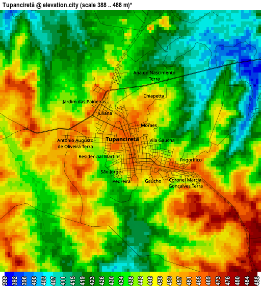
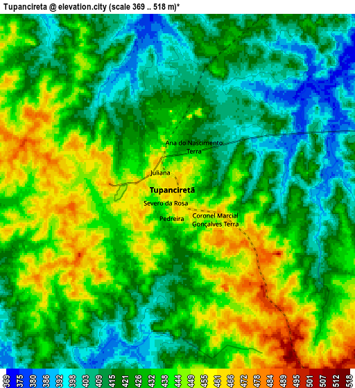
Below is the Elevation map of Tupanciretã, which displays elevation range with different colors. Scale of the first map is from 388 to 488 m (1273 to 1601 ft) with average elevation of 438.3 meters (=1438 ft) [note 1]
These maps also provides idea of topography and contour of this city, they are displayed at different zoom levels. More info about maps, scale and edge coordinates you can find below images.
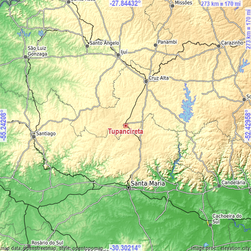
| \ | Map #1 | Map #2 | Topo.Map |
| Scale [m] | 388..488 m | 369..518 m | × |
| Scale [ft] | 1273..1601 ft | 1211..1699 ft | × |
| Average | 438.3 m = 1438 ft | 428.9 m = 1407 ft | × |
| Width | 8.54 km = 5.3 mi | 17.08 km = 10.6 mi | 273.3 km = 169.8 mi |
| Height | 8.54 km = 5.3 mi | 17.08 km = 10.6 mi | 273.3 km = 169.8 mi |
| ↑Max Latitude | -29.042147° | -29.00372° | -27.84432° |
| Latitude at center | -29.08056° | -29.08056° | -29.08056° |
| ↓Min Latitude | -29.118958° | -29.157342° | -30.30214° |
| ← Min Longitude | -53.879775° | -53.923721° | -55.24208° |
| Longitude center | -53.83583° | -53.83583° | -53.83583° |
| →Max Longitude | -53.791885° | -53.747939° | -52.42958° |
Nearby cities:
Cities around Tupanciretã sort by population:
• Santa Maria elevation 146 m
67.2 km,  177°
177°
• Ijuí 329 m
77.4 km,  354°
354°
• Cruz Alta 475 m
53.4 km,  24°
24°
• Santo Ângelo 295 m
96.4 km,  334°
334°
• Santiago 426 m
100.9 km,  262°
262°
• Panambi 421 m
93.5 km, 20°
• Candelária 53 m
120.7 km,  122°
122°
• Júlio de Castilhos 518 m
22.1 km,  137°
137°
• Ibirubá 404 m
88.4 km,  55°
55°
• Não Me Toque 524 m
120.7 km, 55°
• São Pedro do Sul 185 m
68.6 km,  208°
208°
• Espumoso 366 m
103.8 km,  67°
67°
Multilingual:
 En español:
Tupanciretã elevación 464 m.
 En France:
Tupanciretã élévation 464 m.
 Auf Deutsch:
Tupanciretã höhe über dem Meeresspiegel ist 464 m.

Sources and notes:
- [note 1] Map square and city borders are not equal. Map elevation data is calculated only from area inside that square.
- [src 1] Elevation data from geonames database provided with same terms of usage.
- [src 2] The elevation map of Tupanciretã is generated using elevation data from NASA's 3 arcsec (90m) resolution SRTM data.
- [src 3] Base (background) map © OpenStreetMap contributors tiles are generated by Geofabrik and OpenTopoMap.
Copyright & License:
This Tupanciretã Elevation Map is licensed under CC BY-SA. You may reuse any part from this page, if you give a proper credit by linking to this URL:
 More info on terms of use page.