Ibitinga elevation
Ibitinga (São Paulo), Brazil elevation is 500 meters and Ibitinga elevation in feet is 1640 ft above sea level [src 1]. Ibitinga is a populated place (feature code) with elevation that is 118 meters (387 ft) bigger than average city elevation in Brazil.
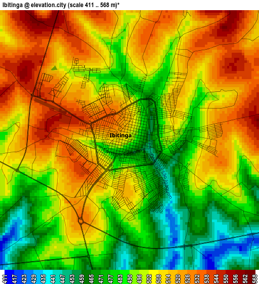
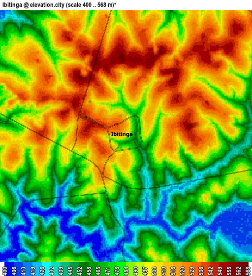
Below is the Elevation map of Ibitinga, which displays elevation range with different colors. Scale of the first map is from 411 to 568 m (1348 to 1864 ft) with average elevation of 500.2 meters (=1641 ft) [note 1]
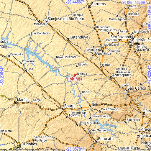
These maps also provides idea of topography and contour of this city, they are displayed at different zoom levels. More info about maps, scale and edge coordinates you can find below images.
| \ | Map #1 | Map #2 | Topo.Map |
| Scale [m] | 411..568 m | 400..568 m | × |
| Scale [ft] | 1348..1864 ft | 1312..1864 ft | × |
| Average | 500.2 m = 1641 ft | 486 m = 1594 ft | × |
| Width | 9.08 km = 5.6 mi | 18.15 km = 11.3 mi | 290.4 km = 180.4 mi |
| Height | 9.08 km = 5.6 mi | 18.15 km = 11.3 mi | 290.4 km = 180.4 mi |
| ↑Max Latitude | -21.71696° | -21.676128° | -20.44587° |
| Latitude at center | -21.75778° | -21.75778° | -21.75778° |
| ↓Min Latitude | -21.798589° | -21.839386° | -23.05781° |
| ← Min Longitude | -48.872835° | -48.916781° | -50.23514° |
| Longitude center | -48.82889° | -48.82889° | -48.82889° |
| →Max Longitude | -48.784945° | -48.740999° | -47.42264° |
Nearby cities:
Cities around Ibitinga sort by population:
• Matão elevation 574 m
50.8 km,  70°
70°
• Taquaritinga 573 m
51.5 km,  40°
40°
• Itápolis 495 m
18.1 km,  5°
5°
• Novo Horizonte 453 m
51.8 km,  308°
308°
• Bariri 449 m
36.4 km,  165°
165°
• Santa Adélia 617 m
57.3 km,  2°
2°
• Itajobi 467 m
54.2 km,  334°
334°
• Borborema 424 m
29.6 km,  301°
301°
• Tabatinga 489 m
15.3 km, 72°
• Boa Esperança do Sul 480 m
52.2 km,  120°
120°
• Itapuí 462 m
54.1 km, 167°
• Boracéia 485 m
48.7 km, 173°
Multilingual:
 En español:
Ibitinga elevación 500 m.
 En France:
Ibitinga élévation 500 m.
 Auf Deutsch:
Ibitinga höhe über dem Meeresspiegel ist 500 m.

Sources and notes:
- [note 1] Map square and city borders are not equal. Map elevation data is calculated only from area inside that square.
- [src 1] Elevation data from geonames database provided with same terms of usage.
- [src 2] The elevation map of Ibitinga is generated using elevation data from NASA's 3 arcsec (90m) resolution SRTM data.
- [src 3] Base (background) map © OpenStreetMap contributors tiles are generated by Geofabrik and OpenTopoMap.
Copyright & License:
This Ibitinga Elevation Map is licensed under CC BY-SA. You may reuse any part from this page, if you give a proper credit by linking to this URL:
 More info on terms of use page.