Ibotirama elevation
Ibotirama (Bahia), Brazil elevation is 426 meters and Ibotirama elevation in feet is 1398 ft above sea level [src 1]. Ibotirama is a populated place (feature code) with elevation that is 44 meters (144 ft) bigger than average city elevation in Brazil.
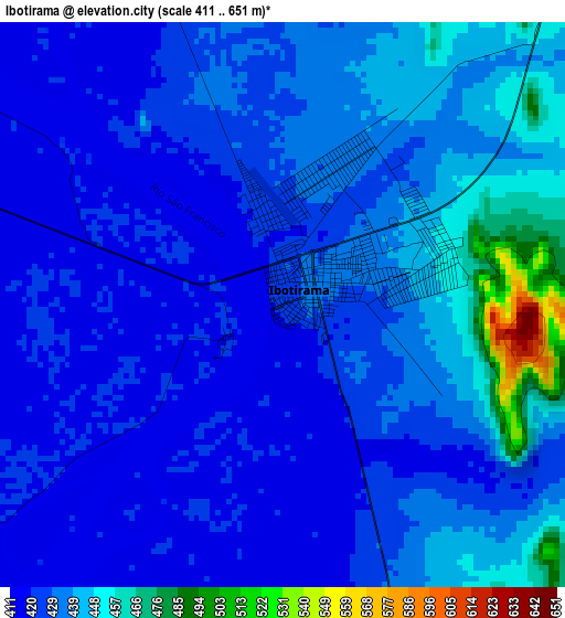
Below is the Elevation map of Ibotirama, which displays elevation range with different colors. Scale of the first map is from 411 to 651 m (1348 to 2136 ft) with average elevation of 432 meters (=1417 ft) [note 1]
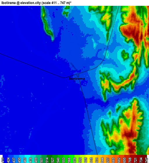
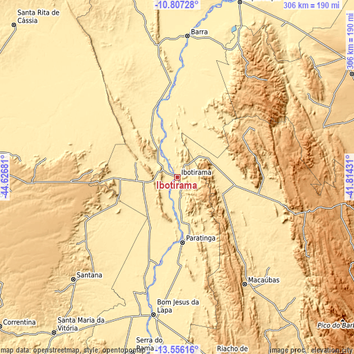
These maps also provides idea of topography and contour of this city, they are displayed at different zoom levels. More info about maps, scale and edge coordinates you can find below images.
| \ | Map #1 | Map #2 | Topo.Map |
| Scale [m] | 411..651 m | 411..747 m | × |
| Scale [ft] | 1348..2136 ft | 1348..2451 ft | × |
| Average | 432 m = 1417 ft | 460.4 m = 1510 ft | × |
| Width | 9.55 km = 5.9 mi | 19.1 km = 11.9 mi | 305.6 km = 189.9 mi |
| Height | 9.55 km = 5.9 mi | 19.1 km = 11.9 mi | 305.7 km = 190 mi |
| ↑Max Latitude | -12.142321° | -12.099356° | -10.80728° |
| Latitude at center | -12.18528° | -12.18528° | -12.18528° |
| ↓Min Latitude | -12.228232° | -12.271177° | -13.55616° |
| ← Min Longitude | -43.264505° | -43.308451° | -44.62681° |
| Longitude center | -43.22056° | -43.22056° | -43.22056° |
| →Max Longitude | -43.176615° | -43.132669° | -41.81431° |
Nearby cities:
Cities around Ibotirama sort by population:
• Bom Jesus da Lapa elevation 439 m
120.9 km,  190°
190°
• Xique Xique 406 m
160.7 km,  19°
19°
• Barra 411 m
122.1 km,  4°
4°
• Seabra 823 m
159.6 km,  99°
99°
• Macaúbas 695 m
108.7 km,  148°
148°
• Ibipeba 697 m
144.8 km,  65°
65°
• Barro Alto 701 m
150 km, 71°
• Riacho de Santana 626 m
161.2 km,  169°
169°
• Paratinga 429 m
56.3 km,  175°
175°
• Boquira 645 m
88.6 km,  143°
143°
• Oliveira dos Brejinhos 572 m
38.2 km,  112°
112°
• Beira Rio 443 m
51.1 km, 98°
Multilingual:
 En español:
Ibotirama elevación 426 m.
 En France:
Ibotirama élévation 426 m.
 Auf Deutsch:
Ibotirama höhe über dem Meeresspiegel ist 426 m.

Sources and notes:
- [note 1] Map square and city borders are not equal. Map elevation data is calculated only from area inside that square.
- [src 1] Elevation data from geonames database provided with same terms of usage.
- [src 2] The elevation map of Ibotirama is generated using elevation data from NASA's 3 arcsec (90m) resolution SRTM data.
- [src 3] Base (background) map © OpenStreetMap contributors tiles are generated by Geofabrik and OpenTopoMap.
Copyright & License:
This Ibotirama Elevation Map is licensed under CC BY-SA. You may reuse any part from this page, if you give a proper credit by linking to this URL:
 More info on terms of use page.