Macaúbas elevation
Macaúbas (Bahia), Brazil elevation is 695 meters and Macaúbas elevation in feet is 2280 ft above sea level [src 1]. Macaúbas is a populated place (feature code) with elevation that is 313 meters (1027 ft) bigger than average city elevation in Brazil.
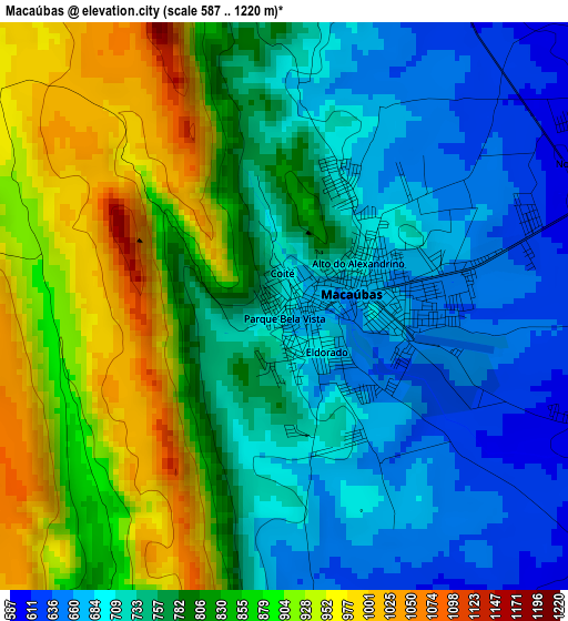
Below is the Elevation map of Macaúbas, which displays elevation range with different colors. Scale of the first map is from 587 to 1220 m (1926 to 4003 ft) with average elevation of 789.2 meters (=2589 ft) [note 1]
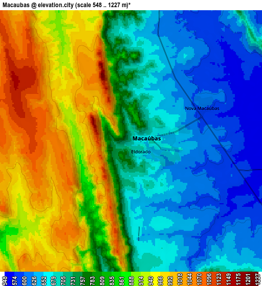
These maps also provides idea of topography and contour of this city, they are displayed at different zoom levels. More info about maps, scale and edge coordinates you can find below images.
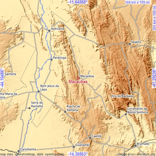
| \ | Map #1 | Map #2 | Topo.Map |
| Scale [m] | 587..1220 m | 548..1227 m | × |
| Scale [ft] | 1926..4003 ft | 1798..4026 ft | × |
| Average | 789.2 m = 2589 ft | 796 m = 2612 ft | × |
| Width | 9.52 km = 5.9 mi | 19.04 km = 11.8 mi | 304.7 km = 189.3 mi |
| Height | 9.52 km = 5.9 mi | 19.04 km = 11.8 mi | 304.7 km = 189.3 mi |
| ↑Max Latitude | -12.976621° | -12.933794° | -11.64568° |
| Latitude at center | -13.01944° | -13.01944° | -13.01944° |
| ↓Min Latitude | -13.062252° | -13.105056° | -14.38563° |
| ← Min Longitude | -42.742555° | -42.786501° | -44.10486° |
| Longitude center | -42.69861° | -42.69861° | -42.69861° |
| →Max Longitude | -42.654665° | -42.610719° | -41.29236° |
Nearby cities:
Cities around Macaúbas sort by population:
• Guanambi elevation 531 m
134.2 km,  183°
183°
• Bom Jesus da Lapa 439 m
82.2 km,  251°
251°
• Caetité 818 m
119.2 km,  168°
168°
• Livramento do Brumado 465 m
116 km,  127°
127°
• Ibotirama 426 m
108.7 km,  328°
328°
• Seabra 823 m
120.9 km,  56°
56°
• Riacho de Santana 626 m
70.5 km,  201°
201°
• Paratinga 429 m
64.1 km,  304°
304°
• Paramirim 611 m
68.5 km, 133°
• Boquira 645 m
22.1 km,  350°
350°
• Oliveira dos Brejinhos 572 m
81 km,  344°
344°
• Beira Rio 443 m
85.3 km,  355°
355°
Multilingual:
 En español:
Macaúbas elevación 695 m.
 En France:
Macaúbas élévation 695 m.
 Auf Deutsch:
Macaúbas höhe über dem Meeresspiegel ist 695 m.

Sources and notes:
- [note 1] Map square and city borders are not equal. Map elevation data is calculated only from area inside that square.
- [src 1] Elevation data from geonames database provided with same terms of usage.
- [src 2] The elevation map of Macaúbas is generated using elevation data from NASA's 3 arcsec (90m) resolution SRTM data.
- [src 3] Base (background) map © OpenStreetMap contributors tiles are generated by Geofabrik and OpenTopoMap.
Copyright & License:
This Macaúbas Elevation Map is licensed under CC BY-SA. You may reuse any part from this page, if you give a proper credit by linking to this URL:
 More info on terms of use page.