Ipatinga elevation
Ipatinga (Minas Gerais), Brazil elevation is 229 meters and Ipatinga elevation in feet is 751 ft above sea level [src 1]. Ipatinga is a populated place (feature code) with elevation that is 153 meters (502 ft) smaller than average city elevation in Brazil.
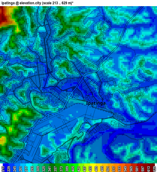
Below is the Elevation map of Ipatinga, which displays elevation range with different colors. Scale of the first map is from 213 to 629 m (699 to 2064 ft) with average elevation of 276.4 meters (=907 ft) [note 1]
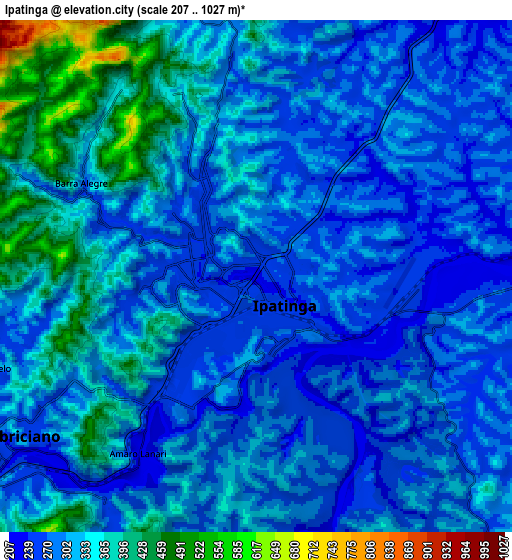
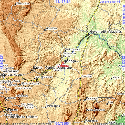
These maps also provides idea of topography and contour of this city, they are displayed at different zoom levels. More info about maps, scale and edge coordinates you can find below images.
| \ | Map #1 | Map #2 | Topo.Map |
| Scale [m] | 213..629 m | 207..1027 m | × |
| Scale [ft] | 699..2064 ft | 679..3369 ft | × |
| Average | 276.4 m = 907 ft | 311 m = 1020 ft | × |
| Width | 9.21 km = 5.7 mi | 18.43 km = 11.5 mi | 294.8 km = 183.2 mi |
| Height | 9.21 km = 5.7 mi | 18.43 km = 11.5 mi | 294.8 km = 183.2 mi |
| ↑Max Latitude | -19.426892° | -19.385443° | -18.13716° |
| Latitude at center | -19.46833° | -19.46833° | -19.46833° |
| ↓Min Latitude | -19.509757° | -19.551174° | -20.78865° |
| ← Min Longitude | -42.580615° | -42.624561° | -43.94292° |
| Longitude center | -42.53667° | -42.53667° | -42.53667° |
| →Max Longitude | -42.492725° | -42.448779° | -41.13042° |
Nearby cities:
Cities around Ipatinga sort by population:
• Coronel Fabriciano elevation 239 m
11.2 km,  239°
239°
• Itabira 794 m
74.2 km,  256°
256°
• Timóteo 356 m
17.2 km,  223°
223°
• Caratinga 586 m
54.9 km,  130°
130°
• Santana do Paraíso 566 m
12.1 km,  343°
343°
• Belo Oriente 261 m
28.2 km,  11°
11°
• Ipaba 236 m
13.7 km,  63°
63°
• Nova Era 632 m
61.1 km, 239°
• Açucena 480 m
44 km,  358°
358°
• Inhapim 525 m
44.6 km,  101°
101°
• Bom Jesus do Galho 508 m
46.3 km,  150°
150°
• São Domingos do Prata 589 m
63.2 km,  225°
225°
Multilingual:
 En español:
Ipatinga elevación 229 m.
 En France:
Ipatinga élévation 229 m.
 Auf Deutsch:
Ipatinga höhe über dem Meeresspiegel ist 229 m.

Sources and notes:
- [note 1] Map square and city borders are not equal. Map elevation data is calculated only from area inside that square.
- [src 1] Elevation data from geonames database provided with same terms of usage.
- [src 2] The elevation map of Ipatinga is generated using elevation data from NASA's 3 arcsec (90m) resolution SRTM data.
- [src 3] Base (background) map © OpenStreetMap contributors tiles are generated by Geofabrik and OpenTopoMap.
Copyright & License:
This Ipatinga Elevation Map is licensed under CC BY-SA. You may reuse any part from this page, if you give a proper credit by linking to this URL:
 More info on terms of use page.