Itapeva elevation
Itapeva (São Paulo), Brazil elevation is 688 meters and Itapeva elevation in feet is 2257 ft above sea level [src 1]. Itapeva is a populated place (feature code) with elevation that is 306 meters (1004 ft) bigger than average city elevation in Brazil.
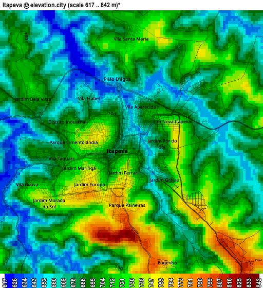
Below is the Elevation map of Itapeva, which displays elevation range with different colors. Scale of the first map is from 617 to 842 m (2024 to 2762 ft) with average elevation of 696.1 meters (=2284 ft) [note 1]
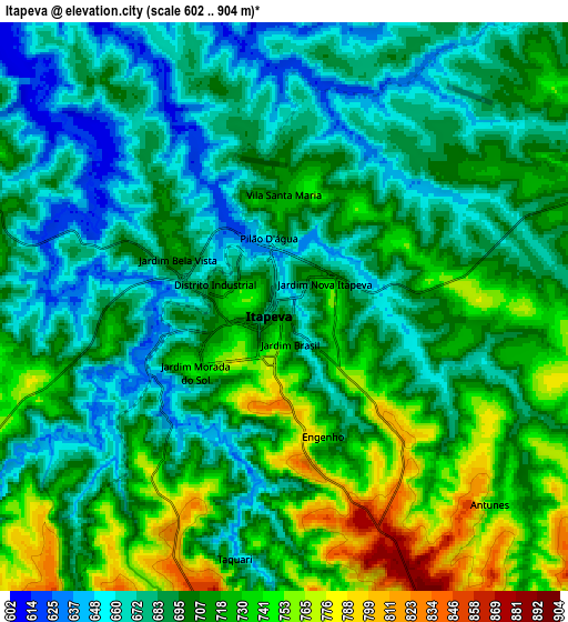
These maps also provides idea of topography and contour of this city, they are displayed at different zoom levels. More info about maps, scale and edge coordinates you can find below images.
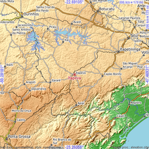
| \ | Map #1 | Map #2 | Topo.Map |
| Scale [m] | 617..842 m | 602..904 m | × |
| Scale [ft] | 2024..2762 ft | 1975..2966 ft | × |
| Average | 696.1 m = 2284 ft | 701.2 m = 2301 ft | × |
| Width | 8.93 km = 5.5 mi | 17.86 km = 11.1 mi | 285.7 km = 177.5 mi |
| Height | 8.93 km = 5.5 mi | 17.86 km = 11.1 mi | 285.7 km = 177.5 mi |
| ↑Max Latitude | -23.942062° | -23.901892° | -22.69105° |
| Latitude at center | -23.98222° | -23.98222° | -23.98222° |
| ↓Min Latitude | -24.022365° | -24.062498° | -25.26058° |
| ← Min Longitude | -48.919505° | -48.963451° | -50.28181° |
| Longitude center | -48.87556° | -48.87556° | -48.87556° |
| →Max Longitude | -48.831615° | -48.787669° | -47.46931° |
Nearby cities:
Cities around Itapeva sort by population:
• Itararé elevation 751 m
48.5 km,  252°
252°
• Capâo Bonito 712 m
53.5 km,  92°
92°
• Itaí 616 m
66.5 km,  340°
340°
• Taquarituba 621 m
62.5 km,  323°
323°
• Apiaí 925 m
58.7 km,  176°
176°
• Paranapanema 610 m
68 km,  13°
13°
• Buri 603 m
35.3 km,  54°
54°
• Sengés 602 m
61.4 km,  256°
256°
• Angatuba 627 m
72.2 km,  40°
40°
• Itaberá 625 m
29.8 km,  296°
296°
• Itaporanga 580 m
69.5 km, 296°
• Ribeirão Branco 873 m
28.8 km,  157°
157°
Multilingual:
 En español:
Itapeva elevación 688 m.
 En France:
Itapeva élévation 688 m.


Sources and notes:
- [note 1] Map square and city borders are not equal. Map elevation data is calculated only from area inside that square.
- [src 1] Elevation data from geonames database provided with same terms of usage.
- [src 2] The elevation map of Itapeva is generated using elevation data from NASA's 3 arcsec (90m) resolution SRTM data.
- [src 3] Base (background) map © OpenStreetMap contributors tiles are generated by Geofabrik and OpenTopoMap.
Copyright & License:
This Itapeva Elevation Map is licensed under CC BY-SA. You may reuse any part from this page, if you give a proper credit by linking to this URL:
 More info on terms of use page.