Itararé elevation
Itararé (São Paulo), Brazil elevation is 751 meters and Itararé elevation in feet is 2464 ft above sea level [src 1]. Itararé is a populated place (feature code) with elevation that is 369 meters (1211 ft) bigger than average city elevation in Brazil.
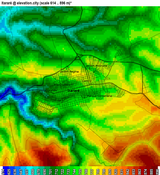
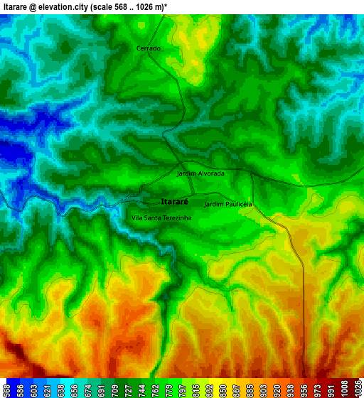
Below is the Elevation map of Itararé, which displays elevation range with different colors. Scale of the first map is from 614 to 896 m (2014 to 2940 ft) with average elevation of 748.7 meters (=2456 ft) [note 1]
These maps also provides idea of topography and contour of this city, they are displayed at different zoom levels. More info about maps, scale and edge coordinates you can find below images.

| \ | Map #1 | Map #2 | Topo.Map |
| Scale [m] | 614..896 m | 568..1026 m | × |
| Scale [ft] | 2014..2940 ft | 1864..3366 ft | × |
| Average | 748.7 m = 2456 ft | 766 m = 2513 ft | × |
| Width | 8.92 km = 5.5 mi | 17.84 km = 11.1 mi | 285.4 km = 177.3 mi |
| Height | 8.92 km = 5.5 mi | 17.84 km = 11.1 mi | 285.4 km = 177.3 mi |
| ↑Max Latitude | -24.072383° | -24.032253° | -22.8226° |
| Latitude at center | -24.1125° | -24.1125° | -24.1125° |
| ↓Min Latitude | -24.152605° | -24.192697° | -25.38953° |
| ← Min Longitude | -49.375615° | -49.419561° | -50.73792° |
| Longitude center | -49.33167° | -49.33167° | -49.33167° |
| →Max Longitude | -49.287725° | -49.243779° | -47.92542° |
Nearby cities:
Cities around Itararé sort by population:
• Itapeva elevation 688 m
48.5 km,  72°
72°
• Jaguariaíva 875 m
41 km,  249°
249°
• Taquarituba 621 m
65 km,  7°
7°
• Apiaí 925 m
66.4 km,  131°
131°
• Piraí do Sul 1000 m
77.6 km,  233°
233°
• Wenceslau Braz 834 m
54.7 km,  299°
299°
• Sengés 602 m
13.3 km,  269°
269°
• Siqueira Campos 622 m
69.5 km,  312°
312°
• Itaberá 625 m
34.2 km,  35°
35°
• Terra Roxa 688 m
76.6 km,  291°
291°
• Itaporanga 580 m
47.8 km,  340°
340°
• Ribeirão Branco 873 m
58.7 km,  101°
101°
Multilingual:
 En español:
Itararé elevación 751 m.
 En France:
Itararé élévation 751 m.


Sources and notes:
- [note 1] Map square and city borders are not equal. Map elevation data is calculated only from area inside that square.
- [src 1] Elevation data from geonames database provided with same terms of usage.
- [src 2] The elevation map of Itararé is generated using elevation data from NASA's 3 arcsec (90m) resolution SRTM data.
- [src 3] Base (background) map © OpenStreetMap contributors tiles are generated by Geofabrik and OpenTopoMap.
Copyright & License:
This Itararé Elevation Map is licensed under CC BY-SA. You may reuse any part from this page, if you give a proper credit by linking to this URL:
 More info on terms of use page.