Ivoti elevation
Ivoti (Rio Grande do Sul), Brazil elevation is 125 meters and Ivoti elevation in feet is 410 ft above sea level [src 1]. Ivoti is a populated place (feature code) with elevation that is 257 meters (843 ft) smaller than average city elevation in Brazil.
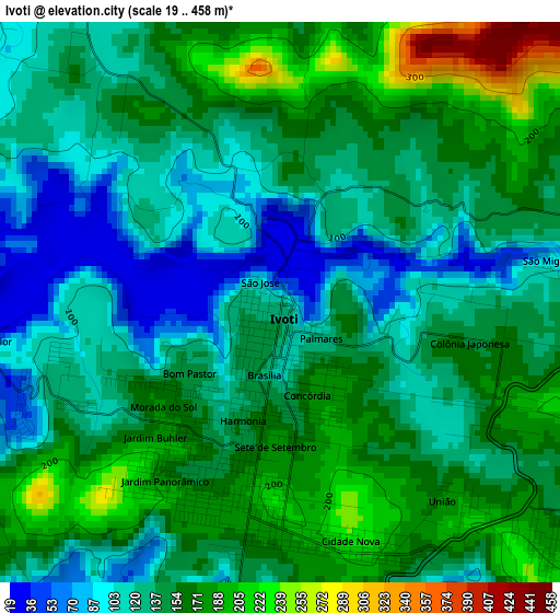
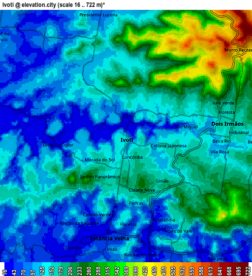
Below is the Elevation map of Ivoti, which displays elevation range with different colors. Scale of the first map is from 19 to 458 m (62 to 1503 ft) with average elevation of 144.5 meters (=474 ft) [note 1]
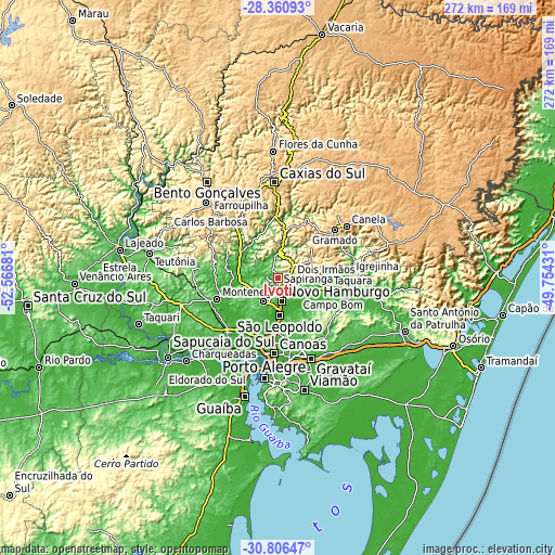
These maps also provides idea of topography and contour of this city, they are displayed at different zoom levels. More info about maps, scale and edge coordinates you can find below images.
| \ | Map #1 | Map #2 | Topo.Map |
| Scale [m] | 19..458 m | 16..722 m | × |
| Scale [ft] | 62..1503 ft | 52..2369 ft | × |
| Average | 144.5 m = 474 ft | 158 m = 518 ft | × |
| Width | 8.5 km = 5.3 mi | 17 km = 10.6 mi | 271.9 km = 169 mi |
| Height | 8.5 km = 5.3 mi | 17 km = 10.6 mi | 271.9 km = 169 mi |
| ↑Max Latitude | -29.552889° | -29.514654° | -28.36093° |
| Latitude at center | -29.59111° | -29.59111° | -29.59111° |
| ↓Min Latitude | -29.629316° | -29.667508° | -30.80647° |
| ← Min Longitude | -51.204505° | -51.248451° | -52.56681° |
| Longitude center | -51.16056° | -51.16056° | -51.16056° |
| →Max Longitude | -51.116615° | -51.072669° | -49.75431° |
Nearby cities:
Cities around Ivoti sort by population:
• Novo Hamburgo elevation 56 m
10.1 km,  163°
163°
• São Leopoldo 10 m
18.9 km,  176°
176°
• Sapucaia 37 m
27 km, 177°
• Esteio 12 m
30.1 km, 183°
• Sapiranga 36 m
15.7 km,  109°
109°
• Montenegro 21 m
31 km,  249°
249°
• Parobé 55 m
31.8 km,  97°
97°
• Estância Velha 43 m
6.5 km,  191°
191°
• Igrejinha 36 m
35.9 km,  87°
87°
• Portão 49 m
14.6 km,  212°
212°
• São Sebastião do Caí 16 m
20.8 km,  271°
271°
• Nova Petrópolis 589 m
24.3 km,  10°
10°
Multilingual:
 En español:
Ivoti elevación 125 m.
 En France:
Ivoti élévation 125 m.


Sources and notes:
- [note 1] Map square and city borders are not equal. Map elevation data is calculated only from area inside that square.
- [src 1] Elevation data from geonames database provided with same terms of usage.
- [src 2] The elevation map of Ivoti is generated using elevation data from NASA's 3 arcsec (90m) resolution SRTM data.
- [src 3] Base (background) map © OpenStreetMap contributors tiles are generated by Geofabrik and OpenTopoMap.
Copyright & License:
This Ivoti Elevation Map is licensed under CC BY-SA. You may reuse any part from this page, if you give a proper credit by linking to this URL:
 More info on terms of use page.