Jaboticabal elevation
Jaboticabal (São Paulo), Brazil elevation is 606 meters and Jaboticabal elevation in feet is 1988 ft above sea level [src 1]. Jaboticabal is a populated place (feature code) with elevation that is 224 meters (735 ft) bigger than average city elevation in Brazil.
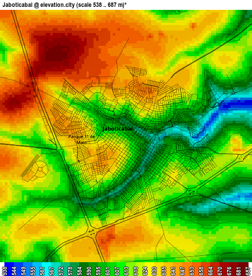
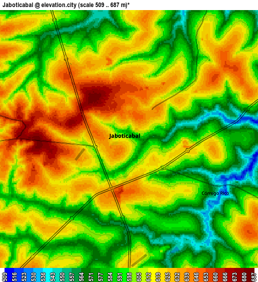
Below is the Elevation map of Jaboticabal, which displays elevation range with different colors. Scale of the first map is from 538 to 687 m (1765 to 2254 ft) with average elevation of 621.5 meters (=2039 ft) [note 1]
These maps also provides idea of topography and contour of this city, they are displayed at different zoom levels. More info about maps, scale and edge coordinates you can find below images.
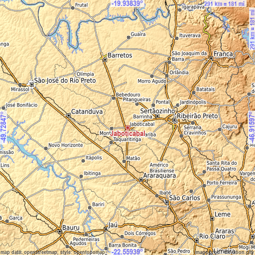
| \ | Map #1 | Map #2 | Topo.Map |
| Scale [m] | 538..687 m | 509..687 m | × |
| Scale [ft] | 1765..2254 ft | 1670..2254 ft | × |
| Average | 621.5 m = 2039 ft | 605.2 m = 1986 ft | × |
| Width | 9.11 km = 5.7 mi | 18.22 km = 11.3 mi | 291.4 km = 181.1 mi |
| Height | 9.11 km = 5.7 mi | 18.22 km = 11.3 mi | 291.4 km = 181.1 mi |
| ↑Max Latitude | -21.213758° | -21.172785° | -19.93839° |
| Latitude at center | -21.25472° | -21.25472° | -21.25472° |
| ↓Min Latitude | -21.29567° | -21.336609° | -22.55939° |
| ← Min Longitude | -48.366165° | -48.410111° | -49.72847° |
| Longitude center | -48.32222° | -48.32222° | -48.32222° |
| →Max Longitude | -48.278275° | -48.234329° | -46.91597° |
Nearby cities:
Cities around Jaboticabal sort by population:
• Sertãozinho elevation 547 m
36.8 km,  69°
69°
• Matão 574 m
39 km,  186°
186°
• Bebedouro 574 m
37.6 km,  334°
334°
• Taquaritinga 573 m
25.3 km,  228°
228°
• Monte Alto 723 m
18.1 km,  267°
267°
• Pontal 531 m
39.2 km,  48°
48°
• Guariba 619 m
15.2 km,  140°
140°
• Pitangueiras 509 m
29.2 km,  20°
20°
• Barrinha 514 m
17.8 km, 67°
• Viradouro 540 m
42.5 km,  3°
3°
• Pradópolis 539 m
29 km,  113°
113°
• Santa Adélia 617 m
50 km, 271°
Multilingual:
 En español:
Jaboticabal elevación 606 m.
 En France:
Jaboticabal élévation 606 m.
 Auf Deutsch:
Jaboticabal höhe über dem Meeresspiegel ist 606 m.

Sources and notes:
- [note 1] Map square and city borders are not equal. Map elevation data is calculated only from area inside that square.
- [src 1] Elevation data from geonames database provided with same terms of usage.
- [src 2] The elevation map of Jaboticabal is generated using elevation data from NASA's 3 arcsec (90m) resolution SRTM data.
- [src 3] Base (background) map © OpenStreetMap contributors tiles are generated by Geofabrik and OpenTopoMap.
Copyright & License:
This Jaboticabal Elevation Map is licensed under CC BY-SA. You may reuse any part from this page, if you give a proper credit by linking to this URL:
 More info on terms of use page.