Marialva elevation
Marialva (Paraná), Brazil elevation is 664 meters and Marialva elevation in feet is 2178 ft above sea level [src 1]. Marialva is a populated place (feature code) with elevation that is 282 meters (925 ft) bigger than average city elevation in Brazil.
Below is the Elevation map of Marialva, which displays elevation range with different colors. Scale of the first map is from 485 to 682 m (1591 to 2238 ft) with average elevation of 582.2 meters (=1910 ft) [note 1]
These maps also provides idea of topography and contour of this city, they are displayed at different zoom levels. More info about maps, scale and edge coordinates you can find below images.
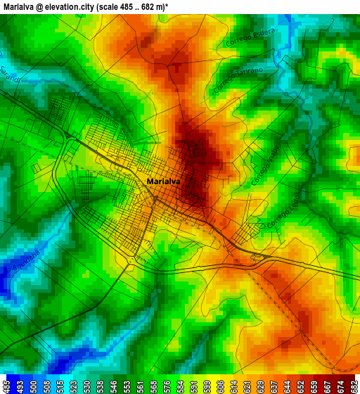
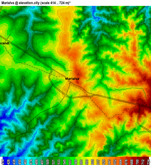
| \ | Map #1 | Map #2 | Topo.Map |
| Scale [m] | 485..682 m | 414..724 m | × |
| Scale [ft] | 1591..2238 ft | 1358..2375 ft | × |
| Average | 582.2 m = 1910 ft | 561 m = 1841 ft | × |
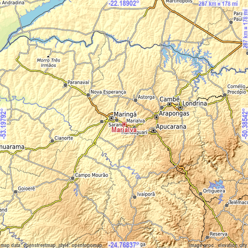
| Width | 8.96 km = 5.6 mi | 17.93 km = 11.1 mi | 286.8 km = 178.2 mi |
| Height | 8.96 km = 5.6 mi | 17.93 km = 11.1 mi | 286.8 km = 178.2 mi |
| ↑Max Latitude | -23.444689° | -23.404365° | -22.18902° |
| Latitude at center | -23.485° | -23.485° | -23.485° |
| ↓Min Latitude | -23.525299° | -23.565585° | -24.76837° |
| ← Min Longitude | -51.835615° | -51.879561° | -53.19792° |
| Longitude center | -51.79167° | -51.79167° | -51.79167° |
| →Max Longitude | -51.747725° | -51.703779° | -50.38542° |
Nearby cities:
Cities around Marialva sort by population:
• Maringá elevation 556 m
16.4 km,  293°
293°
• Apucarana 871 m
34.5 km,  102°
102°
• Arapongas 805 m
38.2 km,  78°
78°
• Cambé 668 m
57.3 km,  66°
66°
• Sarandi 586 m
9.6 km,  298°
298°
• Rolândia 736 m
47.3 km, 65°
• Mandaguari 768 m
14.1 km,  119°
119°
• Paiçandu 486 m
26.4 km,  276°
276°
• Astorga 688 m
30.9 km,  24°
24°
• Jandaia do Sul 814 m
20 km,  130°
130°
• Engenheiro Beltrão 479 m
59.8 km,  234°
234°
• Mandaguaçu 580 m
34.6 km, 296°
Multilingual:
 En español:
Marialva elevación 664 m.
 En France:
Marialva élévation 664 m.
 Auf Deutsch:
Marialva höhe über dem Meeresspiegel ist 664 m.

Sources and notes:
- [note 1] Map square and city borders are not equal. Map elevation data is calculated only from area inside that square.
- [src 1] Elevation data from geonames database provided with same terms of usage.
- [src 2] The elevation map of Marialva is generated using elevation data from NASA's 3 arcsec (90m) resolution SRTM data.
- [src 3] Base (background) map © OpenStreetMap contributors tiles are generated by Geofabrik and OpenTopoMap.
Copyright & License:
This Marialva Elevation Map is licensed under CC BY-SA. You may reuse any part from this page, if you give a proper credit by linking to this URL:
 More info on terms of use page.