Paiçandu elevation
Paiçandu (Paraná), Brazil elevation is 486 meters and Paiçandu elevation in feet is 1594 ft above sea level [src 1]. Paiçandu is a populated place (feature code) with elevation that is 104 meters (341 ft) bigger than average city elevation in Brazil.
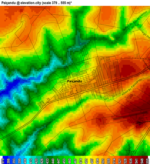
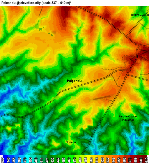
Below is the Elevation map of Paiçandu, which displays elevation range with different colors. Scale of the first map is from 379 to 555 m (1243 to 1821 ft) with average elevation of 479 meters (=1572 ft) [note 1]
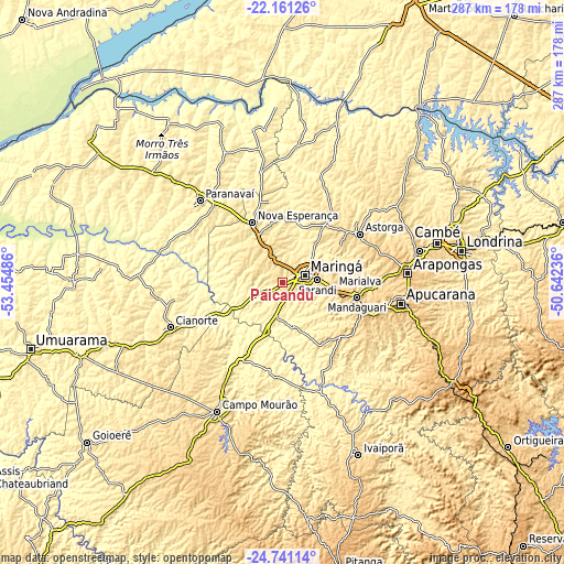
These maps also provides idea of topography and contour of this city, they are displayed at different zoom levels. More info about maps, scale and edge coordinates you can find below images.
| \ | Map #1 | Map #2 | Topo.Map |
| Scale [m] | 379..555 m | 337..610 m | × |
| Scale [ft] | 1243..1821 ft | 1106..2001 ft | × |
| Average | 479 m = 1572 ft | 475 m = 1558 ft | × |
| Width | 8.96 km = 5.6 mi | 17.93 km = 11.1 mi | 286.9 km = 178.3 mi |
| Height | 8.96 km = 5.6 mi | 17.93 km = 11.1 mi | 286.9 km = 178.3 mi |
| ↑Max Latitude | -23.41718° | -23.376848° | -22.16126° |
| Latitude at center | -23.4575° | -23.4575° | -23.4575° |
| ↓Min Latitude | -23.497807° | -23.538102° | -24.74114° |
| ← Min Longitude | -52.092555° | -52.136501° | -53.45486° |
| Longitude center | -52.04861° | -52.04861° | -52.04861° |
| →Max Longitude | -52.004665° | -51.960719° | -50.64236° |
Nearby cities:
Cities around Paiçandu sort by population:
• Maringá elevation 556 m
11.8 km,  72°
72°
• Sarandi 586 m
17.9 km,  85°
85°
• Paranavaí 456 m
60.3 km,  315°
315°
• Mandaguari 768 m
39.8 km,  104°
104°
• Marialva 664 m
26.4 km, 96°
• Astorga 688 m
46.4 km,  57°
57°
• Jandaia do Sul 814 m
44.4 km,  111°
111°
• Engenheiro Beltrão 479 m
44 km,  210°
210°
• Mandaguaçu 580 m
13.2 km,  338°
338°
• Terra Boa 568 m
53.1 km,  229°
229°
• Peabiru 527 m
58.8 km, 210°
• Alto Paraná 520 m
45.8 km, 322°
Multilingual:
 En español:
Paiçandu elevación 486 m.
 En France:
Paiçandu élévation 486 m.
 Auf Deutsch:
Paiçandu höhe über dem Meeresspiegel ist 486 m.

Sources and notes:
- [note 1] Map square and city borders are not equal. Map elevation data is calculated only from area inside that square.
- [src 1] Elevation data from geonames database provided with same terms of usage.
- [src 2] The elevation map of Paiçandu is generated using elevation data from NASA's 3 arcsec (90m) resolution SRTM data.
- [src 3] Base (background) map © OpenStreetMap contributors tiles are generated by Geofabrik and OpenTopoMap.
Copyright & License:
This Paiçandu Elevation Map is licensed under CC BY-SA. You may reuse any part from this page, if you give a proper credit by linking to this URL:
 More info on terms of use page.