Planaltina elevation
Planaltina (Goiás), Brazil elevation is 1038 meters and Planaltina elevation in feet is 3406 ft above sea level [src 1]. Planaltina is a populated place (feature code) with elevation that is 656 meters (2152 ft) bigger than average city elevation in Brazil.
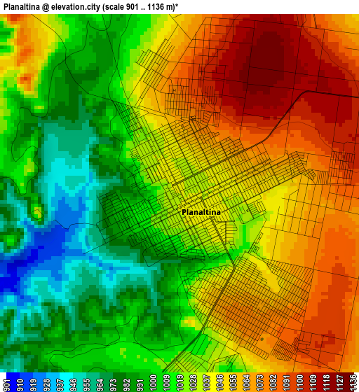
Below is the Elevation map of Planaltina, which displays elevation range with different colors. Scale of the first map is from 901 to 1136 m (2956 to 3727 ft) with average elevation of 1032.3 meters (=3387 ft) [note 1]
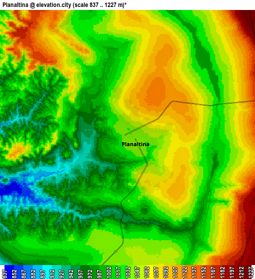
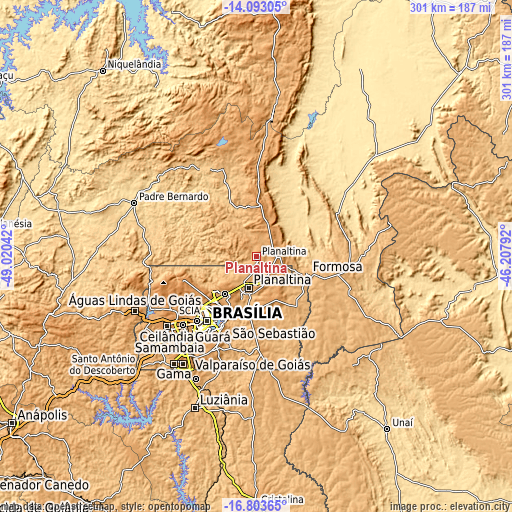
These maps also provides idea of topography and contour of this city, they are displayed at different zoom levels. More info about maps, scale and edge coordinates you can find below images.
| \ | Map #1 | Map #2 | Topo.Map |
| Scale [m] | 901..1136 m | 837..1227 m | × |
| Scale [ft] | 2956..3727 ft | 2746..4026 ft | × |
| Average | 1032.3 m = 3387 ft | 1035.1 m = 3396 ft | × |
| Width | 9.42 km = 5.9 mi | 18.84 km = 11.7 mi | 301.4 km = 187.3 mi |
| Height | 9.42 km = 5.9 mi | 18.84 km = 11.7 mi | 301.4 km = 187.3 mi |
| ↑Max Latitude | -15.410419° | -15.368049° | -14.09305° |
| Latitude at center | -15.45278° | -15.45278° | -15.45278° |
| ↓Min Latitude | -15.495132° | -15.537476° | -16.80365° |
| ← Min Longitude | -47.658115° | -47.702061° | -49.02042° |
| Longitude center | -47.61417° | -47.61417° | -47.61417° |
| →Max Longitude | -47.570225° | -47.526279° | -46.20792° |
Nearby cities:
Cities around Planaltina sort by population:
• Brasília elevation 1136 m
49.6 km,  222°
222°
• Planaltina 987 m
18.7 km,  191°
191°
• Luziânia 932 m
95.9 km,  202°
202°
• Formosa 915 m
31.4 km,  107°
107°
• Unaí 582 m
125.9 km,  143°
143°
• Cristalina 1229 m
146.2 km,  180°
180°
• Niquelândia 580 m
141.8 km,  320°
320°
• Buritis 539 m
128.9 km,  98°
98°
• Padre Bernardo 642 m
78.5 km,  293°
293°
• Pirenópolis 751 m
150.8 km,  252°
252°
• Barro Alto 605 m
149.6 km, 290°
• Abadiânia 1057 m
143.7 km,  234°
234°
Multilingual:
 En español:
Planaltina elevación 1038 m.
 En France:
Planaltina élévation 1038 m.
 Auf Deutsch:
Planaltina höhe über dem Meeresspiegel ist 1038 m.

Sources and notes:
- [note 1] Map square and city borders are not equal. Map elevation data is calculated only from area inside that square.
- [src 1] Elevation data from geonames database provided with same terms of usage.
- [src 2] The elevation map of Planaltina is generated using elevation data from NASA's 3 arcsec (90m) resolution SRTM data.
- [src 3] Base (background) map © OpenStreetMap contributors tiles are generated by Geofabrik and OpenTopoMap.
Copyright & License:
This Planaltina Elevation Map is licensed under CC BY-SA. You may reuse any part from this page, if you give a proper credit by linking to this URL:
 More info on terms of use page.