Unaí elevation
Unaí (Minas Gerais), Brazil elevation is 582 meters and Unaí elevation in feet is 1909 ft above sea level [src 1]. Unaí is a populated place (feature code) with elevation that is 200 meters (656 ft) bigger than average city elevation in Brazil.
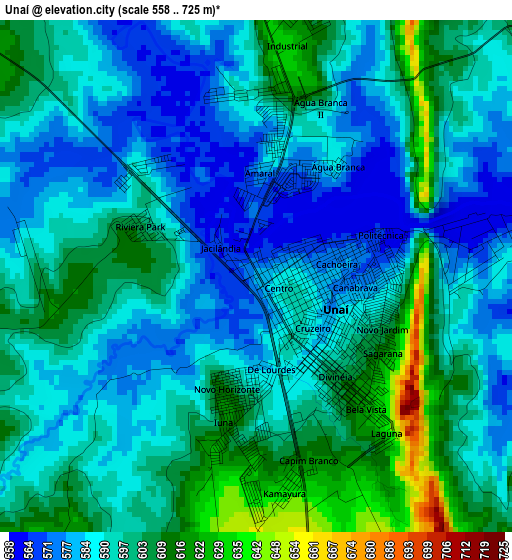
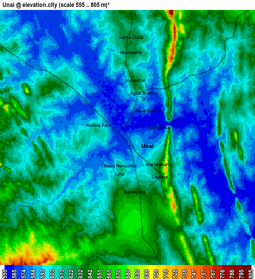
Below is the Elevation map of Unaí, which displays elevation range with different colors. Scale of the first map is from 558 to 725 m (1831 to 2379 ft) with average elevation of 593.8 meters (=1948 ft) [note 1]
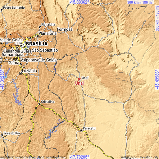
These maps also provides idea of topography and contour of this city, they are displayed at different zoom levels. More info about maps, scale and edge coordinates you can find below images.
| \ | Map #1 | Map #2 | Topo.Map |
| Scale [m] | 558..725 m | 555..805 m | × |
| Scale [ft] | 1831..2379 ft | 1821..2641 ft | × |
| Average | 593.8 m = 1948 ft | 609.8 m = 2001 ft | × |
| Width | 9.38 km = 5.8 mi | 18.75 km = 11.7 mi | 300 km = 186.4 mi |
| Height | 9.38 km = 5.8 mi | 18.75 km = 11.7 mi | 300.1 km = 186.5 mi |
| ↑Max Latitude | -16.315329° | -16.273149° | -15.00362° |
| Latitude at center | -16.3575° | -16.3575° | -16.3575° |
| ↓Min Latitude | -16.399662° | -16.441815° | -17.70205° |
| ← Min Longitude | -46.950055° | -46.994001° | -48.31236° |
| Longitude center | -46.90611° | -46.90611° | -46.90611° |
| →Max Longitude | -46.862165° | -46.818219° | -45.49986° |
Nearby cities:
Cities around Unaí sort by population:
• Brasília elevation 1136 m
126.8 km,  300°
300°
• Planaltina 987 m
114.3 km,  316°
316°
• Luziânia 932 m
112 km,  275°
275°
• Planaltina 1038 m
125.9 km, 323°
• Formosa 915 m
102.1 km,  333°
333°
• Paracatu 693 m
96.2 km,  178°
178°
• Cristalina 1229 m
88.3 km,  238°
238°
• João Pinheiro 775 m
172.6 km,  153°
153°
• Buritis 539 m
97.1 km,  32°
32°
• Arinos 517 m
98.5 km,  60°
60°
• Vianópolis 1006 m
176.9 km,  256°
256°
• Orizona 810 m
165.9 km, 243°
Multilingual:
 En español:
Unaí elevación 582 m.
 En France:
Unaí élévation 582 m.


Sources and notes:
- [note 1] Map square and city borders are not equal. Map elevation data is calculated only from area inside that square.
- [src 1] Elevation data from geonames database provided with same terms of usage.
- [src 2] The elevation map of Unaí is generated using elevation data from NASA's 3 arcsec (90m) resolution SRTM data.
- [src 3] Base (background) map © OpenStreetMap contributors tiles are generated by Geofabrik and OpenTopoMap.
Copyright & License:
This Unaí Elevation Map is licensed under CC BY-SA. You may reuse any part from this page, if you give a proper credit by linking to this URL:
 More info on terms of use page.