Presidente Prudente elevation
Presidente Prudente (São Paulo), Brazil elevation is 462 meters and Presidente Prudente elevation in feet is 1516 ft above sea level [src 1]. Presidente Prudente is a populated place (feature code) with elevation that is 80 meters (262 ft) bigger than average city elevation in Brazil.
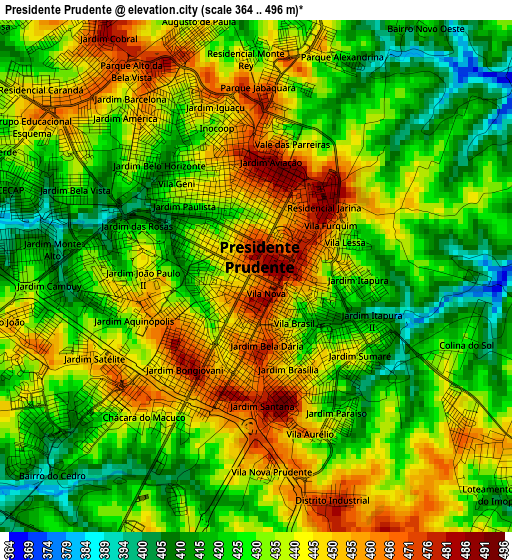
Below is the Elevation map of Presidente Prudente, which displays elevation range with different colors. Scale of the first map is from 364 to 496 m (1194 to 1627 ft) with average elevation of 433.2 meters (=1421 ft) [note 1]
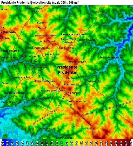
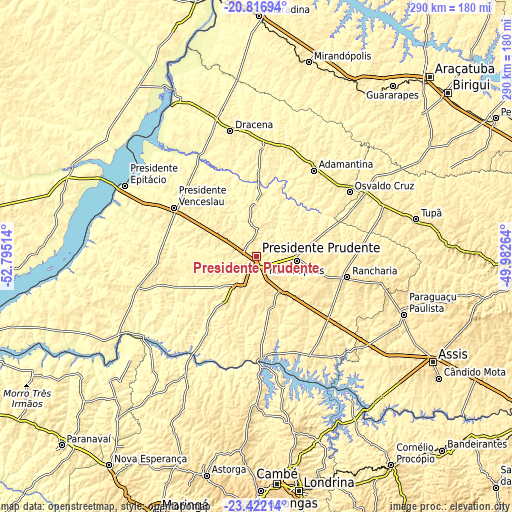
These maps also provides idea of topography and contour of this city, they are displayed at different zoom levels. More info about maps, scale and edge coordinates you can find below images.
| \ | Map #1 | Map #2 | Topo.Map |
| Scale [m] | 364..496 m | 338..509 m | × |
| Scale [ft] | 1194..1627 ft | 1109..1670 ft | × |
| Average | 433.2 m = 1421 ft | 420.5 m = 1380 ft | × |
| Width | 9.05 km = 5.6 mi | 18.11 km = 11.3 mi | 289.7 km = 180 mi |
| Height | 9.05 km = 5.6 mi | 18.11 km = 11.3 mi | 289.7 km = 180 mi |
| ↑Max Latitude | -22.084845° | -22.044118° | -20.81694° |
| Latitude at center | -22.12556° | -22.12556° | -22.12556° |
| ↓Min Latitude | -22.166263° | -22.206955° | -23.42214° |
| ← Min Longitude | -51.432835° | -51.476781° | -52.79514° |
| Longitude center | -51.38889° | -51.38889° | -51.38889° |
| →Max Longitude | -51.344945° | -51.300999° | -49.98264° |
Nearby cities:
Cities around Presidente Prudente sort by population:
• Presidente Venceslau elevation 428 m
54.5 km,  300°
300°
• Adamantina 468 m
58.8 km,  33°
33°
• Rancharia 521 m
52.3 km,  102°
102°
• Pirapozinho 491 m
20.2 km,  214°
214°
• Álvares Machado 484 m
10 km, 300°
• Martinópolis 501 m
22.6 km, 95°
• Santo Anastácio 395 m
39.3 km,  324°
324°
• Regente Feijó 511 m
13.9 km,  140°
140°
• Lucélia 453 m
59.1 km,  40°
40°
• Presidente Bernardes 417 m
21.5 km,  308°
308°
• Mirante do Paranapanema 446 m
56.4 km,  250°
250°
• Paulista Flórida 375 m
61.6 km,  18°
18°
Multilingual:
 En español:
Presidente Prudente elevación 462 m.
 En France:
Presidente Prudente élévation 462 m.
 Auf Deutsch:
Presidente Prudente höhe über dem Meeresspiegel ist 462 m.
 На русском:
Президенти-Пруденти высота над уровнем моря 462 м
Sources and notes:
- [note 1] Map square and city borders are not equal. Map elevation data is calculated only from area inside that square.
- [src 1] Elevation data from geonames database provided with same terms of usage.
- [src 2] The elevation map of Presidente Prudente is generated using elevation data from NASA's 3 arcsec (90m) resolution SRTM data.
- [src 3] Base (background) map © OpenStreetMap contributors tiles are generated by Geofabrik and OpenTopoMap.
Copyright & License:
This Presidente Prudente Elevation Map is licensed under CC BY-SA. You may reuse any part from this page, if you give a proper credit by linking to this URL:
 More info on terms of use page.