São Borja elevation
São Borja (Rio Grande do Sul), Brazil elevation is 98 meters and São Borja elevation in feet is 322 ft above sea level [src 1]. São Borja is a populated place (feature code) with elevation that is 284 meters (932 ft) smaller than average city elevation in Brazil.
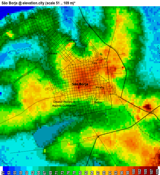
Below is the Elevation map of São Borja, which displays elevation range with different colors. Scale of the first map is from 51 to 109 m (167 to 358 ft) with average elevation of 75.6 meters (=248 ft) [note 1]
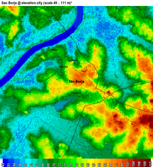
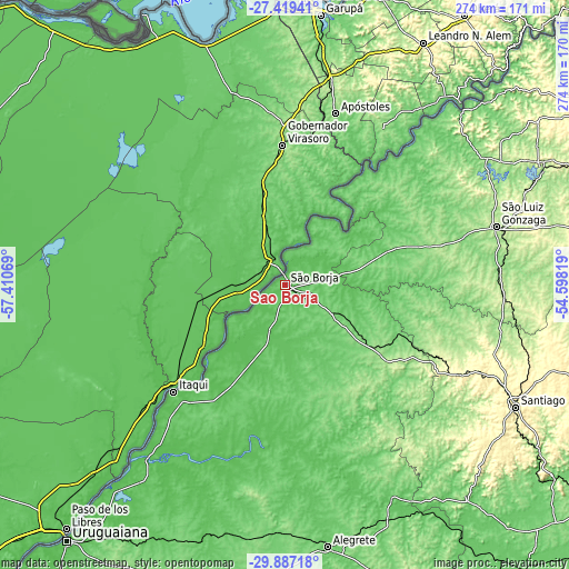
These maps also provides idea of topography and contour of this city, they are displayed at different zoom levels. More info about maps, scale and edge coordinates you can find below images.
| \ | Map #1 | Map #2 | Topo.Map |
| Scale [m] | 51..109 m | 49..111 m | × |
| Scale [ft] | 167..358 ft | 161..364 ft | × |
| Average | 75.6 m = 248 ft | 71.6 m = 235 ft | × |
| Width | 8.58 km = 5.3 mi | 17.15 km = 10.7 mi | 274.4 km = 170.5 mi |
| Height | 8.58 km = 5.3 mi | 17.15 km = 10.7 mi | 274.4 km = 170.5 mi |
| ↑Max Latitude | -28.621992° | -28.58341° | -27.41941° |
| Latitude at center | -28.66056° | -28.66056° | -28.66056° |
| ↓Min Latitude | -28.699114° | -28.737654° | -29.88718° |
| ← Min Longitude | -56.048385° | -56.092331° | -57.41069° |
| Longitude center | -56.00444° | -56.00444° | -56.00444° |
| →Max Longitude | -55.960495° | -55.916549° | -54.59819° |
Nearby cities:
Cities around São Borja sort by population:
• Uruguaiana elevation 79 m
160.8 km,  220°
220°
• Alegrete 107 m
126.5 km,  170°
170°
• Santo Ângelo 295 m
174.9 km,  76°
76°
• Santa Rosa 284 m
173.1 km,  59°
59°
• Santiago 426 m
125.4 km,  118°
118°
• Itaqui 61 m
74.3 km,  225°
225°
• São Luiz Gonzaga 264 m
105.7 km,  74°
74°
• São Francisco de Assis 134 m
130.3 km,  139°
139°
• Cacequi 112 m
177.7 km, 139°
• Giruá 432 m
176.5 km, 66°
• Cerro Largo 200 m
136.3 km, 65°
• Butia Inferior 192 m
127.6 km, 59°
Multilingual:
 En español:
São Borja elevación 98 m.
 En France:
São Borja élévation 98 m.
 Auf Deutsch:
São Borja höhe über dem Meeresspiegel ist 98 m.

Sources and notes:
- [note 1] Map square and city borders are not equal. Map elevation data is calculated only from area inside that square.
- [src 1] Elevation data from geonames database provided with same terms of usage.
- [src 2] The elevation map of São Borja is generated using elevation data from NASA's 3 arcsec (90m) resolution SRTM data.
- [src 3] Base (background) map © OpenStreetMap contributors tiles are generated by Geofabrik and OpenTopoMap.
Copyright & License:
This São Borja Elevation Map is licensed under CC BY-SA. You may reuse any part from this page, if you give a proper credit by linking to this URL:
 More info on terms of use page.