Almeirim elevation
Almeirim (Pará), Brazil elevation is 6 meters and Almeirim elevation in feet is 20 ft above sea level [src 1]. Almeirim is a populated place (feature code) with elevation that is 376 meters (1234 ft) smaller than average city elevation in Brazil.
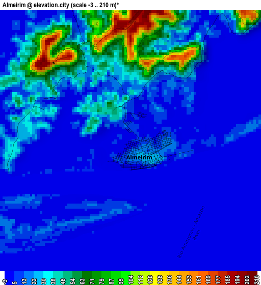
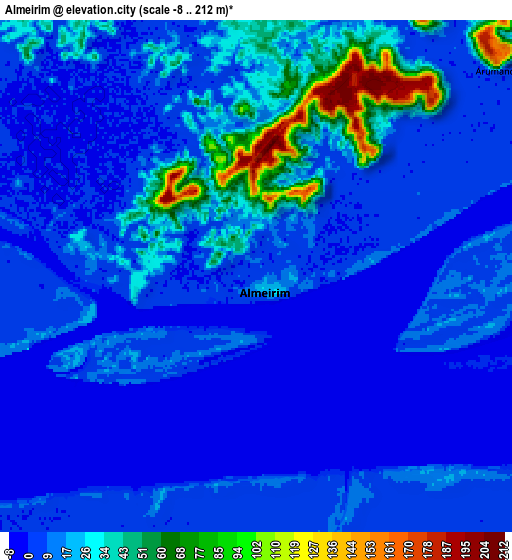
Below is the Elevation map of Almeirim, which displays elevation range with different colors. Scale of the first map is from -3 to 210 m (-10 to 689 ft) with average elevation of 19.2 meters (=63 ft) [note 1]
These maps also provides idea of topography and contour of this city, they are displayed at different zoom levels. More info about maps, scale and edge coordinates you can find below images.
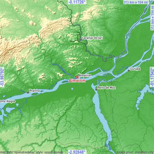
| \ | Map #1 | Map #2 | Topo.Map |
| Scale [m] | -3..210 m | -8..212 m | × |
| Scale [ft] | -10..689 ft | -26..696 ft | × |
| Average | 19.2 m = 63 ft | 15.2 m = 50 ft | × |
| Width | 9.77 km = 6.1 mi | 19.54 km = 12.1 mi | 312.6 km = 194.2 mi |
| Height | 9.77 km = 6.1 mi | 19.54 km = 12.1 mi | 312.6 km = 194.2 mi |
| ↑Max Latitude | -1.4794° | -1.435469° | -0.11726° |
| Latitude at center | -1.52333° | -1.52333° | -1.52333° |
| ↓Min Latitude | -1.567259° | -1.611188° | -2.92848° |
| ← Min Longitude | -52.625615° | -52.669561° | -53.98792° |
| Longitude center | -52.58167° | -52.58167° | -52.58167° |
| →Max Longitude | -52.537725° | -52.493779° | -51.17542° |
Nearby cities:
Cities around Almeirim sort by population:
• Macapá elevation 17 m
242 km,  44°
44°
• Santana 0 m
225.3 km, 43°
• Altamira 101 m
191.4 km,  167°
167°
• Breves 7 m
234.2 km,  94°
94°
• Alenquer 32 m
244.2 km,  259°
259°
• Monte Alegre 57 m
174.9 km,  252°
252°
• Portel 12 m
201 km,  103°
103°
• Porto de Moz 20 m
45.6 km,  123°
123°
• Mazagão 15 m
212.5 km, 42°
• Prainha 35 m
104.5 km, 252°
• Gurupá 4 m
105.5 km,  82°
82°
• Senador José Porfírio 7 m
137.7 km,  149°
149°
Multilingual:
 En español:
Almeirim elevación 6 m.
 En France:
Almeirim élévation 6 m.


Sources and notes:
- [note 1] Map square and city borders are not equal. Map elevation data is calculated only from area inside that square.
- [src 1] Elevation data from geonames database provided with same terms of usage.
- [src 2] The elevation map of Almeirim is generated using elevation data from NASA's 3 arcsec (90m) resolution SRTM data.
- [src 3] Base (background) map © OpenStreetMap contributors tiles are generated by Geofabrik and OpenTopoMap.
Copyright & License:
This Almeirim Elevation Map is licensed under CC BY-SA. You may reuse any part from this page, if you give a proper credit by linking to this URL:
 More info on terms of use page.