Aracati elevation
Aracati (Ceará), Brazil elevation is 12 meters and Aracati elevation in feet is 39 ft above sea level [src 1]. Aracati is a seat of a second-order administrative division (feature code) with elevation that is 370 meters (1214 ft) smaller than average city elevation in Brazil.
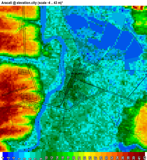
Below is the Elevation map of Aracati, which displays elevation range with different colors. Scale of the first map is from -4 to 43 m (-13 to 141 ft) with average elevation of 11.9 meters (=39 ft) [note 1]
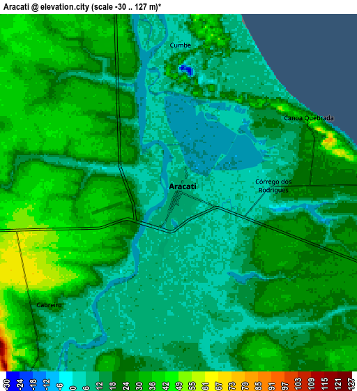
These maps also provides idea of topography and contour of this city, they are displayed at different zoom levels. More info about maps, scale and edge coordinates you can find below images.
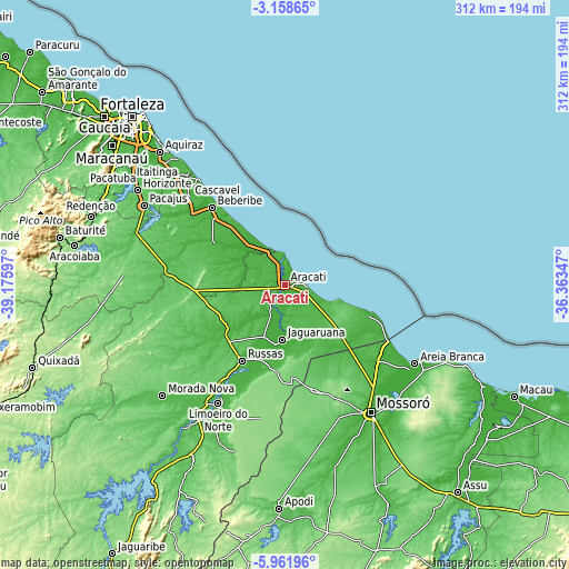
| \ | Map #1 | Map #2 | Topo.Map |
| Scale [m] | -4..43 m | -30..127 m | × |
| Scale [ft] | -13..141 ft | -98..417 ft | × |
| Average | 11.9 m = 39 ft | 21 m = 69 ft | × |
| Width | 9.74 km = 6.1 mi | 19.48 km = 12.1 mi | 311.7 km = 193.7 mi |
| Height | 9.74 km = 6.1 mi | 19.48 km = 12.1 mi | 311.7 km = 193.7 mi |
| ↑Max Latitude | -4.517863° | -4.474052° | -3.15865° |
| Latitude at center | -4.56167° | -4.56167° | -4.56167° |
| ↓Min Latitude | -4.605475° | -4.649277° | -5.96196° |
| ← Min Longitude | -37.813665° | -37.857611° | -39.17597° |
| Longitude center | -37.76972° | -37.76972° | -37.76972° |
| →Max Longitude | -37.725775° | -37.681829° | -36.36347° |
Nearby cities:
Cities around Aracati sort by population:
• Mossoró elevation 24 m
84.1 km,  145°
145°
• Cascavel 31 m
70.8 km,  312°
312°
• Pacajus 80 m
88 km,  299°
299°
• Russas 26 m
47.9 km,  208°
208°
• Morada Nova 54 m
90.2 km,  227°
227°
• Beberibe 20 m
58.3 km,  316°
316°
• Limoeiro do Norte 35 m
74.4 km, 209°
• Jaguaruana 15 m
30.3 km,  182°
182°
• Areia Branca 11 m
82.7 km,  122°
122°
• Baraúna 97 m
60.1 km,  163°
163°
• Quixeré 31 m
61.9 km,  203°
203°
• Chorozinho 56 m
85.8 km,  289°
289°
Multilingual:
 En español:
Aracati elevación 12 m.
 En France:
Aracati élévation 12 m.


Sources and notes:
- [note 1] Map square and city borders are not equal. Map elevation data is calculated only from area inside that square.
- [src 1] Elevation data from geonames database provided with same terms of usage.
- [src 2] The elevation map of Aracati is generated using elevation data from NASA's 3 arcsec (90m) resolution SRTM data.
- [src 3] Base (background) map © OpenStreetMap contributors tiles are generated by Geofabrik and OpenTopoMap.
Copyright & License:
This Aracati Elevation Map is licensed under CC BY-SA. You may reuse any part from this page, if you give a proper credit by linking to this URL:
 More info on terms of use page.