Mossoró elevation
Mossoró (Rio Grande do Norte), Brazil elevation is 24 meters and Mossoró elevation in feet is 79 ft above sea level [src 1]. Mossoró is a populated place (feature code) with elevation that is 358 meters (1175 ft) smaller than average city elevation in Brazil.
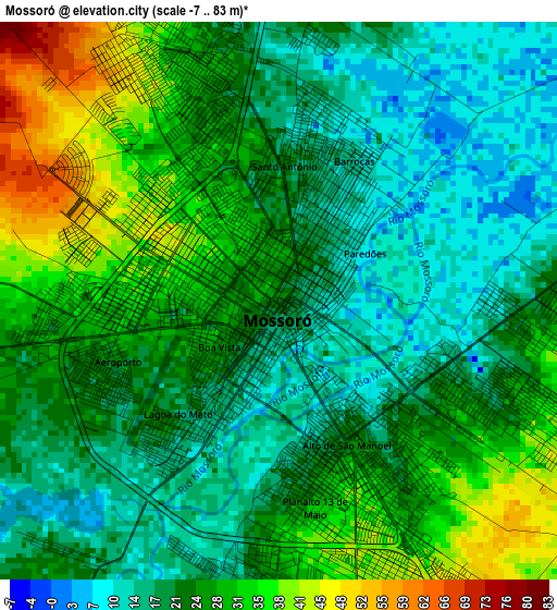
Below is the Elevation map of Mossoró, which displays elevation range with different colors. Scale of the first map is from -7 to 83 m (-23 to 272 ft) with average elevation of 24.1 meters (=79 ft) [note 1]
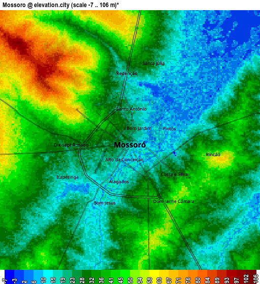
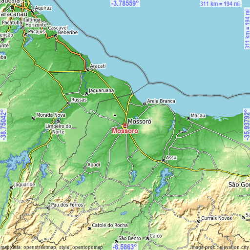
These maps also provides idea of topography and contour of this city, they are displayed at different zoom levels. More info about maps, scale and edge coordinates you can find below images.
| \ | Map #1 | Map #2 | Topo.Map |
| Scale [m] | -7..83 m | -7..106 m | × |
| Scale [ft] | -23..272 ft | -23..348 ft | × |
| Average | 24.1 m = 79 ft | 32.3 m = 106 ft | × |
| Width | 9.73 km = 6 mi | 19.47 km = 12.1 mi | 311.4 km = 193.5 mi |
| Height | 9.73 km = 6 mi | 19.47 km = 12.1 mi | 311.4 km = 193.5 mi |
| ↑Max Latitude | -5.143733° | -5.099963° | -3.78559° |
| Latitude at center | -5.1875° | -5.1875° | -5.1875° |
| ↓Min Latitude | -5.231264° | -5.275025° | -6.5863° |
| ← Min Longitude | -37.388115° | -37.432061° | -38.75042° |
| Longitude center | -37.34417° | -37.34417° | -37.34417° |
| →Max Longitude | -37.300225° | -37.256279° | -35.93792° |
Nearby cities:
Cities around Mossoró sort by population:
• Russas elevation 26 m
75.2 km,  291°
291°
• Açu 36 m
64.8 km,  131°
131°
• Jaguaruana 15 m
62.4 km,  309°
309°
• Areia Branca 11 m
34.5 km,  41°
41°
• Apodi 73 m
73.1 km,  223°
223°
• Baraúna 97 m
32.5 km, 291°
• Caraúbas 152 m
71.3 km,  199°
199°
• Quixeré 31 m
72.5 km,  280°
280°
• Pendências 14 m
69.3 km,  96°
96°
• Upanema 46 m
51.4 km,  169°
169°
• Governador Dix Sept Rosado 35 m
36 km,  212°
212°
• Ipanguaçu 20 m
64.2 km,  122°
122°
Multilingual:
 En español:
Mossoró elevación 24 m.
 En France:
Mossoró élévation 24 m.


Sources and notes:
- [note 1] Map square and city borders are not equal. Map elevation data is calculated only from area inside that square.
- [src 1] Elevation data from geonames database provided with same terms of usage.
- [src 2] The elevation map of Mossoró is generated using elevation data from NASA's 3 arcsec (90m) resolution SRTM data.
- [src 3] Base (background) map © OpenStreetMap contributors tiles are generated by Geofabrik and OpenTopoMap.
Copyright & License:
This Mossoró Elevation Map is licensed under CC BY-SA. You may reuse any part from this page, if you give a proper credit by linking to this URL:
 More info on terms of use page.