Areia elevation
Areia (Paraíba), Brazil elevation is 546 meters and Areia elevation in feet is 1791 ft above sea level [src 1]. Areia is a populated place (feature code) with elevation that is 164 meters (538 ft) bigger than average city elevation in Brazil.
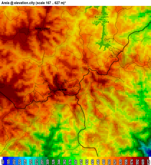
Below is the Elevation map of Areia, which displays elevation range with different colors. Scale of the first map is from 167 to 627 m (548 to 2057 ft) with average elevation of 489.9 meters (=1607 ft) [note 1]
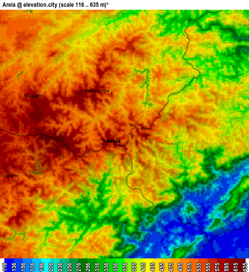
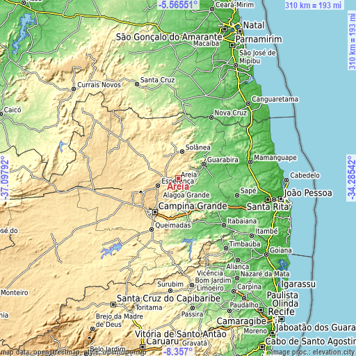
These maps also provides idea of topography and contour of this city, they are displayed at different zoom levels. More info about maps, scale and edge coordinates you can find below images.
| \ | Map #1 | Map #2 | Topo.Map |
| Scale [m] | 167..627 m | 116..635 m | × |
| Scale [ft] | 548..2057 ft | 381..2083 ft | × |
| Average | 489.9 m = 1607 ft | 429.7 m = 1410 ft | × |
| Width | 9.7 km = 6 mi | 19.4 km = 12.1 mi | 310.4 km = 192.9 mi |
| Height | 9.7 km = 6 mi | 19.4 km = 12.1 mi | 310.4 km = 192.9 mi |
| ↑Max Latitude | -6.919707° | -6.87608° | -5.56551° |
| Latitude at center | -6.96333° | -6.96333° | -6.96333° |
| ↓Min Latitude | -7.006949° | -7.050564° | -8.357° |
| ← Min Longitude | -35.735615° | -35.779561° | -37.09792° |
| Longitude center | -35.69167° | -35.69167° | -35.69167° |
| →Max Longitude | -35.647725° | -35.603779° | -34.28542° |
Nearby cities:
Cities around Areia sort by population:
• Guarabira elevation 94 m
25.3 km,  61°
61°
• Esperança 610 m
19.8 km,  247°
247°
• Solânea 188 m
28.6 km,  35°
35°
• Alagoa Grande 334 m
22.7 km,  162°
162°
• Remígio 561 m
10 km,  280°
280°
• Alagoa Nova 440 m
14 km,  211°
211°
• Lagoa Seca 631 m
29.2 km,  217°
217°
• Arara 461 m
16.7 km,  333°
333°
• Alagoinha 136 m
16.3 km,  84°
84°
• Bananeiras 556 m
24.6 km,  15°
15°
• Mulungu 89 m
26.2 km,  105°
105°
• Massaranduba 371 m
28.5 km,  202°
202°
Multilingual:
 En español:
Areia elevación 546 m.
 En France:
Areia élévation 546 m.


Sources and notes:
- [note 1] Map square and city borders are not equal. Map elevation data is calculated only from area inside that square.
- [src 1] Elevation data from geonames database provided with same terms of usage.
- [src 2] The elevation map of Areia is generated using elevation data from NASA's 3 arcsec (90m) resolution SRTM data.
- [src 3] Base (background) map © OpenStreetMap contributors tiles are generated by Geofabrik and OpenTopoMap.
Copyright & License:
This Areia Elevation Map is licensed under CC BY-SA. You may reuse any part from this page, if you give a proper credit by linking to this URL:
 More info on terms of use page.