João Pessoa elevation
João Pessoa (Paraíba), Brazil elevation is 45 meters and João Pessoa elevation in feet is 148 ft above sea level [src 1]. João Pessoa is a seat of a first-order administrative division (feature code) with elevation that is 337 meters (1106 ft) smaller than average city elevation in Brazil.
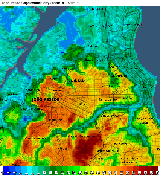
Below is the Elevation map of João Pessoa, which displays elevation range with different colors. Scale of the first map is from -9 to 69 m (-30 to 226 ft) with average elevation of 24.2 meters (=79 ft) [note 1]
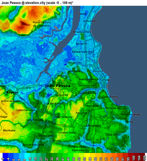
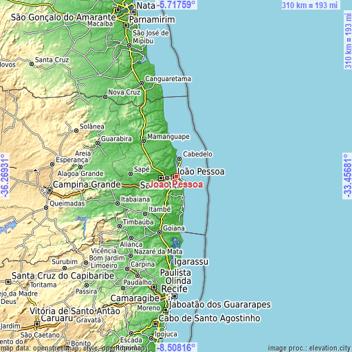
These maps also provides idea of topography and contour of this city, they are displayed at different zoom levels. More info about maps, scale and edge coordinates you can find below images.
| \ | Map #1 | Map #2 | Topo.Map |
| Scale [m] | -9..69 m | -9..109 m | × |
| Scale [ft] | -30..226 ft | -30..358 ft | × |
| Average | 24.2 m = 79 ft | 28.6 m = 94 ft | × |
| Width | 9.7 km = 6 mi | 19.39 km = 12 mi | 310.3 km = 192.8 mi |
| Height | 9.7 km = 6 mi | 19.39 km = 12 mi | 310.3 km = 192.8 mi |
| ↑Max Latitude | -7.071391° | -7.027778° | -5.71759° |
| Latitude at center | -7.115° | -7.115° | -7.115° |
| ↓Min Latitude | -7.158605° | -7.202206° | -8.50816° |
| ← Min Longitude | -34.907005° | -34.950951° | -36.26931° |
| Longitude center | -34.86306° | -34.86306° | -34.86306° |
| →Max Longitude | -34.819115° | -34.775169° | -33.45681° |
Nearby cities:
Cities around João Pessoa sort by population:
• Santa Rita elevation 6 m
12.7 km,  270°
270°
• Bayeux 12 m
7.7 km,  261°
261°
• Cabedelo 7 m
15.2 km,  12°
12°
• Mamanguape 39 m
42.3 km,  316°
316°
• Conde 116 m
16.8 km,  196°
196°
• Pedras de Fogo 174 m
42.4 km,  221°
221°
• Caaporã 32 m
44.8 km,  186°
186°
• Rio Tinto 35 m
42.2 km,  325°
325°
• Alhandra 39 m
36.4 km, 188°
• Pitimbu 12 m
40 km,  171°
171°
• Pilar 38 m
46.9 km,  248°
248°
• Cruz do Espírito Santo 19 m
24.8 km, 263°
Multilingual:
 En español:
João Pessoa elevación 45 m.
 En France:
João Pessoa élévation 45 m.
 Auf Deutsch:
João Pessoa höhe über dem Meeresspiegel ist 45 m.

Sources and notes:
- [note 1] Map square and city borders are not equal. Map elevation data is calculated only from area inside that square.
- [src 1] Elevation data from geonames database provided with same terms of usage.
- [src 2] The elevation map of João Pessoa is generated using elevation data from NASA's 3 arcsec (90m) resolution SRTM data.
- [src 3] Base (background) map © OpenStreetMap contributors tiles are generated by Geofabrik and OpenTopoMap.
Copyright & License:
This João Pessoa Elevation Map is licensed under CC BY-SA. You may reuse any part from this page, if you give a proper credit by linking to this URL:
 More info on terms of use page.