Parnarama elevation
Parnarama (Maranhão), Brazil elevation is 87 meters and Parnarama elevation in feet is 285 ft above sea level [src 1]. Parnarama is a populated place (feature code) with elevation that is 295 meters (968 ft) smaller than average city elevation in Brazil.
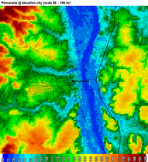
Below is the Elevation map of Parnarama, which displays elevation range with different colors. Scale of the first map is from 66 to 196 m (217 to 643 ft) with average elevation of 116.8 meters (=383 ft) [note 1]
These maps also provides idea of topography and contour of this city, they are displayed at different zoom levels. More info about maps, scale and edge coordinates you can find below images.
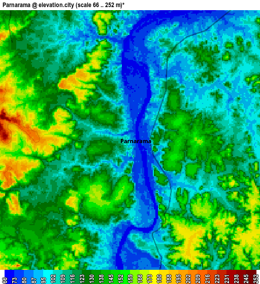
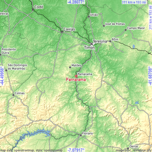
| \ | Map #1 | Map #2 | Topo.Map |
| Scale [m] | 66..196 m | 66..252 m | × |
| Scale [ft] | 217..643 ft | 217..827 ft | × |
| Average | 116.8 m = 383 ft | 123.1 m = 404 ft | × |
| Width | 9.72 km = 6 mi | 19.45 km = 12.1 mi | 311.2 km = 193.4 mi |
| Height | 9.72 km = 6 mi | 19.45 km = 12.1 mi | 311.2 km = 193.4 mi |
| ↑Max Latitude | -5.637939° | -5.594205° | -4.28077° |
| Latitude at center | -5.68167° | -5.68167° | -5.68167° |
| ↓Min Latitude | -5.725398° | -5.769122° | -7.07917° |
| ← Min Longitude | -43.137275° | -43.181221° | -44.49958° |
| Longitude center | -43.09333° | -43.09333° | -43.09333° |
| →Max Longitude | -43.049385° | -43.005439° | -41.68708° |
Nearby cities:
Cities around Parnarama sort by population:
• Teresina elevation 87 m
73.4 km,  26°
26°
• Timon 76 m
71.2 km,  23°
23°
• Buriti Bravo 227 m
83.7 km,  258°
258°
• Estreito 199 m
20.7 km,  236°
236°
• Demerval Lobão 116 m
58.5 km,  52°
52°
• Água Branca 247 m
55.7 km,  114°
114°
• Regeneração 177 m
75.9 km,  143°
143°
• Amarante 102 m
68.2 km,  156°
156°
• São Pedro do Piauí 263 m
49.8 km,  123°
123°
• Beneditinos 118 m
84.4 km,  72°
72°
• Monsenhor Gil 129 m
55.3 km,  76°
76°
• Palmeirais 90 m
33.1 km,  174°
174°
Multilingual:
 En español:
Parnarama elevación 87 m.
 En France:
Parnarama élévation 87 m.
 Auf Deutsch:
Parnarama höhe über dem Meeresspiegel ist 87 m.

Sources and notes:
- [note 1] Map square and city borders are not equal. Map elevation data is calculated only from area inside that square.
- [src 1] Elevation data from geonames database provided with same terms of usage.
- [src 2] The elevation map of Parnarama is generated using elevation data from NASA's 3 arcsec (90m) resolution SRTM data.
- [src 3] Base (background) map © OpenStreetMap contributors tiles are generated by Geofabrik and OpenTopoMap.
Copyright & License:
This Parnarama Elevation Map is licensed under CC BY-SA. You may reuse any part from this page, if you give a proper credit by linking to this URL:
 More info on terms of use page.