Timon elevation
Timon (Maranhão), Brazil elevation is 76 meters and Timon elevation in feet is 249 ft above sea level [src 1]. Timon is a populated place (feature code) with elevation that is 306 meters (1004 ft) smaller than average city elevation in Brazil.
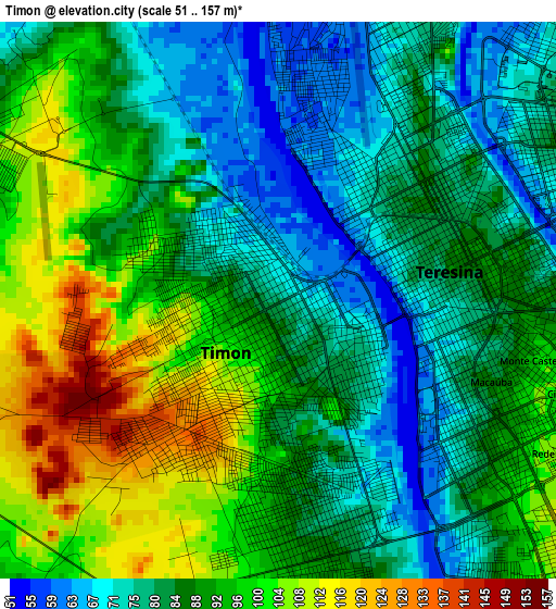
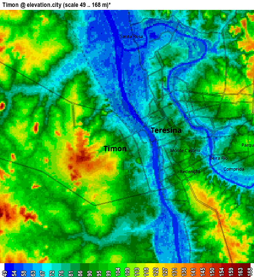
Below is the Elevation map of Timon, which displays elevation range with different colors. Scale of the first map is from 51 to 157 m (167 to 515 ft) with average elevation of 87.9 meters (=288 ft) [note 1]
These maps also provides idea of topography and contour of this city, they are displayed at different zoom levels. More info about maps, scale and edge coordinates you can find below images.
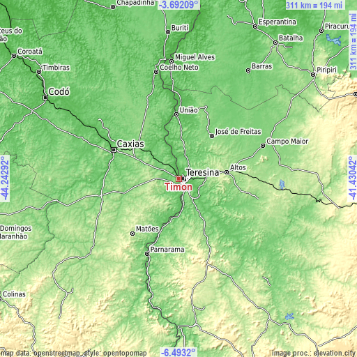
| \ | Map #1 | Map #2 | Topo.Map |
| Scale [m] | 51..157 m | 49..168 m | × |
| Scale [ft] | 167..515 ft | 161..551 ft | × |
| Average | 87.9 m = 288 ft | 90.2 m = 296 ft | × |
| Width | 9.73 km = 6 mi | 19.47 km = 12.1 mi | 311.5 km = 193.6 mi |
| Height | 9.73 km = 6 mi | 19.47 km = 12.1 mi | 311.5 km = 193.6 mi |
| ↑Max Latitude | -5.050397° | -5.006621° | -3.69209° |
| Latitude at center | -5.09417° | -5.09417° | -5.09417° |
| ↓Min Latitude | -5.13794° | -5.181707° | -6.4932° |
| ← Min Longitude | -42.880615° | -42.924561° | -44.24292° |
| Longitude center | -42.83667° | -42.83667° | -42.83667° |
| →Max Longitude | -42.792725° | -42.748779° | -41.43042° |
Nearby cities:
Cities around Timon sort by population:
• Teresina elevation 87 m
3.9 km,  81°
81°
• Caxias 83 m
63.2 km,  294°
294°
• Campo Maior 128 m
79.7 km,  68°
68°
• Altos 192 m
42.2 km, 81°
• José de Freitas 131 m
47.4 km,  37°
37°
• Estreito 199 m
89.2 km,  210°
210°
• União 60 m
56.6 km,  356°
356°
• Demerval Lobão 116 m
34.3 km,  148°
148°
• Parnarama 87 m
71.2 km,  203°
203°
• Beneditinos 118 m
65.4 km,  127°
127°
• Monsenhor Gil 129 m
58.1 km, 154°
• Alto Longá 141 m
71.5 km,  104°
104°
Multilingual:
 En español:
Timon elevación 76 m.
 En France:
Timon élévation 76 m.


Sources and notes:
- [note 1] Map square and city borders are not equal. Map elevation data is calculated only from area inside that square.
- [src 1] Elevation data from geonames database provided with same terms of usage.
- [src 2] The elevation map of Timon is generated using elevation data from NASA's 3 arcsec (90m) resolution SRTM data.
- [src 3] Base (background) map © OpenStreetMap contributors tiles are generated by Geofabrik and OpenTopoMap.
Copyright & License:
This Timon Elevation Map is licensed under CC BY-SA. You may reuse any part from this page, if you give a proper credit by linking to this URL:
 More info on terms of use page.