Passagem Franca elevation
Passagem Franca (Maranhão), Brazil elevation is 237 meters and Passagem Franca elevation in feet is 778 ft above sea level [src 1]. Passagem Franca is a populated place (feature code) with elevation that is 145 meters (476 ft) smaller than average city elevation in Brazil.
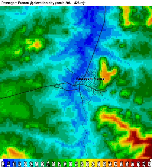
Below is the Elevation map of Passagem Franca, which displays elevation range with different colors. Scale of the first map is from 206 to 426 m (676 to 1398 ft) with average elevation of 267.7 meters (=878 ft) [note 1]
These maps also provides idea of topography and contour of this city, they are displayed at different zoom levels. More info about maps, scale and edge coordinates you can find below images.

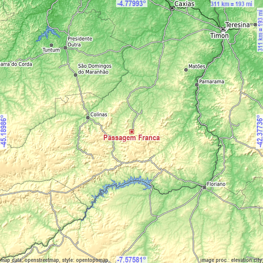
| \ | Map #1 | Map #2 | Topo.Map |
| Scale [m] | 206..426 m | 195..460 m | × |
| Scale [ft] | 676..1398 ft | 640..1509 ft | × |
| Average | 267.7 m = 878 ft | 292.4 m = 959 ft | × |
| Width | 9.72 km = 6 mi | 19.43 km = 12.1 mi | 310.9 km = 193.2 mi |
| Height | 9.72 km = 6 mi | 19.43 km = 12.1 mi | 310.9 km = 193.2 mi |
| ↑Max Latitude | -6.136028° | -6.092333° | -4.77993° |
| Latitude at center | -6.17972° | -6.17972° | -6.17972° |
| ↓Min Latitude | -6.223408° | -6.267093° | -7.57581° |
| ← Min Longitude | -43.827555° | -43.871501° | -45.18986° |
| Longitude center | -43.78361° | -43.78361° | -43.78361° |
| →Max Longitude | -43.739665° | -43.695719° | -42.37736° |
Nearby cities:
Cities around Passagem Franca sort by population:
• Colinas elevation 142 m
54.2 km,  288°
288°
• São João dos Patos 346 m
36.2 km,  165°
165°
• São Domingos do Maranhão 179 m
94.5 km,  315°
315°
• Buriti Bravo 227 m
38.5 km,  351°
351°
• Estreito 199 m
73.7 km,  53°
53°
• Paraibano 282 m
35.8 km,  218°
218°
• Parnarama 87 m
94.3 km, 54°
• Raposa 387 m
57.9 km,  229°
229°
• Pastos Bons 250 m
57 km,  214°
214°
• Fortuna 210 m
64.7 km, 320°
• Mirador 176 m
67.5 km,  251°
251°
• Palmeirais 90 m
82.7 km,  74°
74°
Multilingual:
 En español:
Passagem Franca elevación 237 m.
 En France:
Passagem Franca élévation 237 m.
 Auf Deutsch:
Passagem Franca höhe über dem Meeresspiegel ist 237 m.

Sources and notes:
- [note 1] Map square and city borders are not equal. Map elevation data is calculated only from area inside that square.
- [src 1] Elevation data from geonames database provided with same terms of usage.
- [src 2] The elevation map of Passagem Franca is generated using elevation data from NASA's 3 arcsec (90m) resolution SRTM data.
- [src 3] Base (background) map © OpenStreetMap contributors tiles are generated by Geofabrik and OpenTopoMap.
Copyright & License:
This Passagem Franca Elevation Map is licensed under CC BY-SA. You may reuse any part from this page, if you give a proper credit by linking to this URL:
 More info on terms of use page.