Piancó elevation
Piancó (Paraíba), Brazil elevation is 268 meters and Piancó elevation in feet is 879 ft above sea level [src 1]. Piancó is a populated place (feature code) with elevation that is 114 meters (374 ft) smaller than average city elevation in Brazil.
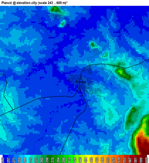
Below is the Elevation map of Piancó, which displays elevation range with different colors. Scale of the first map is from 243 to 609 m (797 to 1998 ft) with average elevation of 283 meters (=928 ft) [note 1]
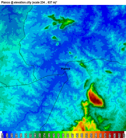
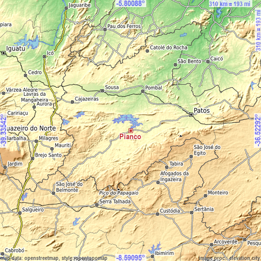
These maps also provides idea of topography and contour of this city, they are displayed at different zoom levels. More info about maps, scale and edge coordinates you can find below images.
| \ | Map #1 | Map #2 | Topo.Map |
| Scale [m] | 243..609 m | 234..637 m | × |
| Scale [ft] | 797..1998 ft | 768..2090 ft | × |
| Average | 283 m = 928 ft | 294.6 m = 967 ft | × |
| Width | 9.7 km = 6 mi | 19.39 km = 12 mi | 310.2 km = 192.7 mi |
| Height | 9.7 km = 6 mi | 19.39 km = 12 mi | 310.3 km = 192.8 mi |
| ↑Max Latitude | -7.154459° | -7.110854° | -5.80088° |
| Latitude at center | -7.19806° | -7.19806° | -7.19806° |
| ↓Min Latitude | -7.241657° | -7.28525° | -8.59095° |
| ← Min Longitude | -37.973115° | -38.017061° | -39.33542° |
| Longitude center | -37.92917° | -37.92917° | -37.92917° |
| →Max Longitude | -37.885225° | -37.841279° | -36.52292° |
Nearby cities:
Cities around Piancó sort by population:
• Sousa elevation 229 m
58.9 km,  325°
325°
• Pombal 185 m
49.6 km,  16°
16°
• Tabira 571 m
61.3 km,  135°
135°
• Itaporanga 295 m
27.1 km,  244°
244°
• Princesa Isabel 686 m
60.3 km,  186°
186°
• Coremas 218 m
20.5 km,  354°
354°
• Juàzeirinho 222 m
44.5 km,  342°
342°
• São José de Piranhas 344 m
63.8 km,  277°
277°
• Tavares 718 m
49 km,  173°
173°
• Manaíra 758 m
61.7 km,  203°
203°
• Imaculada 763 m
51 km,  114°
114°
• Juru 588 m
39.6 km,  162°
162°
Multilingual:
 En español:
Piancó elevación 268 m.
 En France:
Piancó élévation 268 m.


Sources and notes:
- [note 1] Map square and city borders are not equal. Map elevation data is calculated only from area inside that square.
- [src 1] Elevation data from geonames database provided with same terms of usage.
- [src 2] The elevation map of Piancó is generated using elevation data from NASA's 3 arcsec (90m) resolution SRTM data.
- [src 3] Base (background) map © OpenStreetMap contributors tiles are generated by Geofabrik and OpenTopoMap.
Copyright & License:
This Piancó Elevation Map is licensed under CC BY-SA. You may reuse any part from this page, if you give a proper credit by linking to this URL:
 More info on terms of use page.