Tutóia elevation
Tutóia (Maranhão), Brazil elevation is 5 meters and Tutóia elevation in feet is 16 ft above sea level [src 1]. Tutóia is a populated place (feature code) with elevation that is 377 meters (1237 ft) smaller than average city elevation in Brazil.
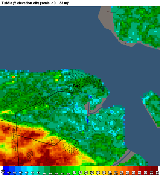
Below is the Elevation map of Tutóia, which displays elevation range with different colors. Scale of the first map is from -10 to 33 m (-33 to 108 ft) with average elevation of 7.4 meters (=24 ft) [note 1]
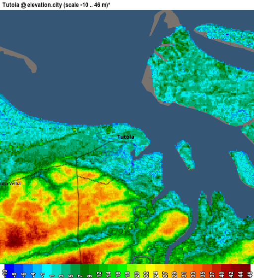
These maps also provides idea of topography and contour of this city, they are displayed at different zoom levels. More info about maps, scale and edge coordinates you can find below images.
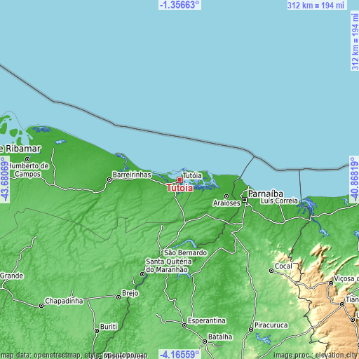
| \ | Map #1 | Map #2 | Topo.Map |
| Scale [m] | -10..33 m | -10..46 m | × |
| Scale [ft] | -33..108 ft | -33..151 ft | × |
| Average | 7.4 m = 24 ft | 11.3 m = 37 ft | × |
| Width | 9.76 km = 6.1 mi | 19.52 km = 12.1 mi | 312.3 km = 194.1 mi |
| Height | 9.76 km = 6.1 mi | 19.52 km = 12.1 mi | 312.4 km = 194.1 mi |
| ↑Max Latitude | -2.718045° | -2.674148° | -1.35663° |
| Latitude at center | -2.76194° | -2.76194° | -2.76194° |
| ↓Min Latitude | -2.805833° | -2.849725° | -4.16559° |
| ← Min Longitude | -42.318385° | -42.362331° | -43.68069° |
| Longitude center | -42.27444° | -42.27444° | -42.27444° |
| →Max Longitude | -42.230495° | -42.186549° | -40.86819° |
Nearby cities:
Cities around Tutóia sort by population:
• Parnaíba elevation 9 m
57.5 km,  106°
106°
• Barreirinhas 5 m
61.3 km,  270°
270°
• Santa Quitéria do Maranhão 29 m
89.1 km,  199°
199°
• Luzilândia 39 m
78.1 km,  187°
187°
• Cocal 129 m
112.1 km,  134°
134°
• Brejo 70 m
115.4 km,  207°
207°
• Luís Correia 3 m
68.7 km,  100°
100°
• São Bernardo 29 m
68.5 km, 193°
• Buriti dos Lopes 23 m
64.5 km,  135°
135°
• Araioses 7 m
43.6 km, 109°
• Matias Olímpio 71 m
110.6 km, 196°
• Atins 3 m
56.2 km,  292°
292°
Multilingual:
 En español:
Tutóia elevación 5 m.
 En France:
Tutóia élévation 5 m.


Sources and notes:
- [note 1] Map square and city borders are not equal. Map elevation data is calculated only from area inside that square.
- [src 1] Elevation data from geonames database provided with same terms of usage.
- [src 2] The elevation map of Tutóia is generated using elevation data from NASA's 3 arcsec (90m) resolution SRTM data.
- [src 3] Base (background) map © OpenStreetMap contributors tiles are generated by Geofabrik and OpenTopoMap.
Copyright & License:
This Tutóia Elevation Map is licensed under CC BY-SA. You may reuse any part from this page, if you give a proper credit by linking to this URL:
 More info on terms of use page.