Guayaramerín elevation
Guayaramerín (El Beni, Provincia Vaca Diez), Bolivia elevation is 136 meters and Guayaramerín elevation in feet is 446 ft above sea level [src 1]. Guayaramerín is a populated place (feature code) with elevation that is 1740 meters (5709 ft) smaller than average city elevation in Bolivia.
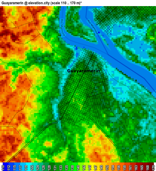
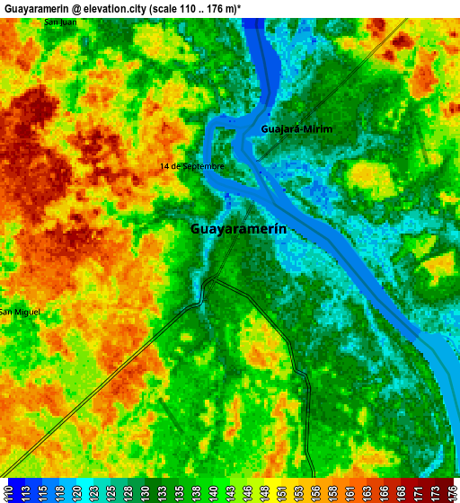
Below is the Elevation map of Guayaramerín, which displays elevation range with different colors. Scale of the first map is from 110 to 170 m (361 to 558 ft) with average elevation of 135.3 meters (=444 ft) [note 1]
These maps also provides idea of topography and contour of this city, they are displayed at different zoom levels. More info about maps, scale and edge coordinates you can find below images.
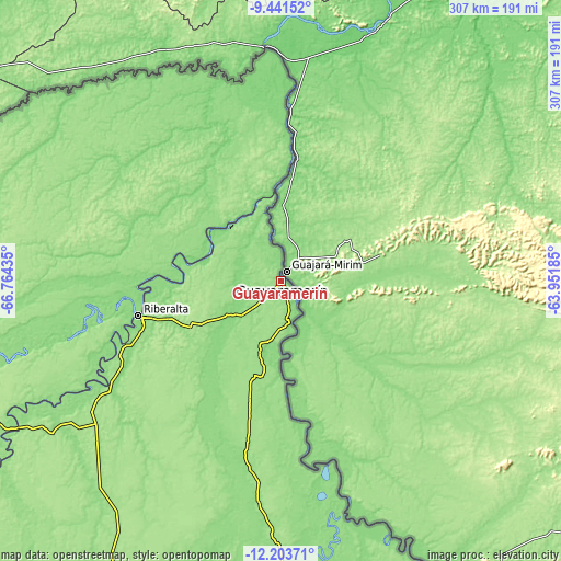
| \ | Map #1 | Map #2 | Topo.Map |
| Scale [m] | 110..170 m | 110..176 m | × |
| Scale [ft] | 361..558 ft | 361..577 ft | × |
| Average | 135.3 m = 444 ft | 140.5 m = 461 ft | × |
| Width | 9.6 km = 6 mi | 19.2 km = 11.9 mi | 307.1 km = 190.8 mi |
| Height | 9.6 km = 6 mi | 19.2 km = 11.9 mi | 307.2 km = 190.9 mi |
| ↑Max Latitude | -10.782634° | -10.739461° | -9.44152° |
| Latitude at center | -10.8258° | -10.8258° | -10.8258° |
| ↓Min Latitude | -10.86896° | -10.912114° | -12.20371° |
| ← Min Longitude | -65.402045° | -65.445991° | -66.76435° |
| Longitude center | -65.3581° | -65.3581° | -65.3581° |
| →Max Longitude | -65.314155° | -65.270209° | -63.95185° |
Nearby cities:
Cities around Guayaramerín sort by population:
• Riberalta elevation 150 m
79.6 km,  255°
255°
• Cobija 200 m
373.1 km,  266°
266°
• Santa Ana de Yacuma 148 m
324.6 km,  181°
181°
• Reyes 189 m
441.5 km,  209°
209°
• Santa Rosa 167 m
406.7 km,  204°
204°
• San Ramón 136 m
282 km,  165°
165°
• Nueva Manoa 122 m
123.2 km,  358°
358°
Multilingual:
 En español:
Guayaramerín elevación 136 m.
 En France:
Guayaramerín élévation 136 m.
 Auf Deutsch:
Guayaramerín höhe über dem Meeresspiegel ist 136 m.

Sources and notes:
- [note 1] Map square and city borders are not equal. Map elevation data is calculated only from area inside that square.
- [src 1] Elevation data from geonames database provided with same terms of usage.
- [src 2] The elevation map of Guayaramerín is generated using elevation data from NASA's 3 arcsec (90m) resolution SRTM data.
- [src 3] Base (background) map © OpenStreetMap contributors tiles are generated by Geofabrik and OpenTopoMap.
Copyright & License:
This Guayaramerín Elevation Map is licensed under CC BY-SA. You may reuse any part from this page, if you give a proper credit by linking to this URL:
 More info on terms of use page.