Parakou elevation
Parakou (Borgou), Benin elevation is 369 meters and Parakou elevation in feet is 1211 ft above sea level [src 1]. Parakou is a seat of a first-order administrative division (feature code) with elevation that is 206 meters (676 ft) bigger than average city elevation in Benin.
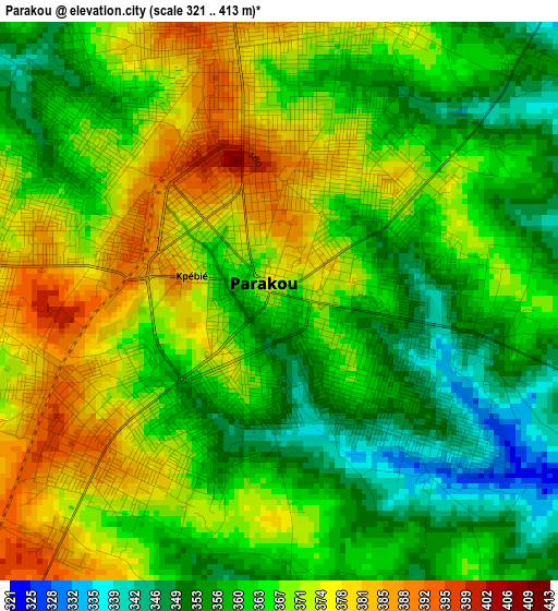
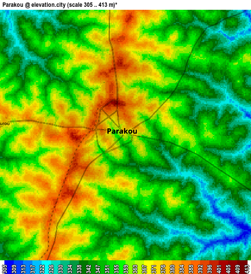
Below is the Elevation map of Parakou, which displays elevation range with different colors. Scale of the first map is from 321 to 413 m (1053 to 1355 ft) with average elevation of 365.1 meters (=1198 ft) [note 1]
These maps also provides idea of topography and contour of this city, they are displayed at different zoom levels. More info about maps, scale and edge coordinates you can find below images.
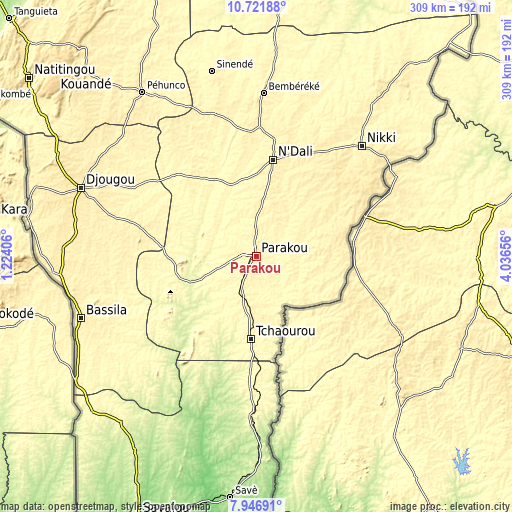
| \ | Map #1 | Map #2 | Topo.Map |
| Scale [m] | 321..413 m | 305..413 m | × |
| Scale [ft] | 1053..1355 ft | 1001..1355 ft | × |
| Average | 365.1 m = 1198 ft | 355.2 m = 1165 ft | × |
| Width | 9.64 km = 6 mi | 19.29 km = 12 mi | 308.5 km = 191.7 mi |
| Height | 9.64 km = 6 mi | 19.29 km = 12 mi | 308.6 km = 191.8 mi |
| ↑Max Latitude | 9.38052° | 9.423875° | 10.72188° |
| Latitude at center | 9.33716° | 9.33716° | 9.33716° |
| ↓Min Latitude | 9.293794° | 9.250423° | 7.94691° |
| ← Min Longitude | 2.586365° | 2.542419° | 1.22406° |
| Longitude center | 2.63031° | 2.63031° | 2.63031° |
| →Max Longitude | 2.674255° | 2.718201° | 4.03656° |
Nearby cities:
Cities around Parakou sort by population:
• Djougou elevation 444 m
113.5 km,  291°
291°
• Kandi 294 m
202.6 km,  9°
9°
• Natitingou 450 m
174.2 km,  308°
308°
• Savé 190 m
145.7 km,  186°
186°
• Nikki 403 m
92.4 km,  43°
43°
• Savalou 181 m
172.4 km,  204°
204°
• Bembèrèkè 445 m
99.1 km,  2°
2°
• Bassila 388 m
112.1 km,  250°
250°
• Dassa-Zoumé 156 m
183.2 km, 195°
• Tchaourou 332 m
50.2 km,  184°
184°
• Bétérou 259 m
43.6 km, 249°
• Guilmaro 472 m
168.8 km,  324°
324°
Multilingual:
 En español:
Parakou elevación 369 m.
 En France:
Parakou élévation 369 m.


Sources and notes:
- [note 1] Map square and city borders are not equal. Map elevation data is calculated only from area inside that square.
- [src 1] Elevation data from geonames database provided with same terms of usage.
- [src 2] The elevation map of Parakou is generated using elevation data from NASA's 3 arcsec (90m) resolution SRTM data.
- [src 3] Base (background) map © OpenStreetMap contributors tiles are generated by Geofabrik and OpenTopoMap.
Copyright & License:
This Parakou Elevation Map is licensed under CC BY-SA. You may reuse any part from this page, if you give a proper credit by linking to this URL:
 More info on terms of use page.