Bozhurishte elevation
Bozhurishte (Sofia, Obshtina Bozhurishte), Bulgaria elevation is 568 meters and Bozhurishte elevation in feet is 1864 ft above sea level [src 1]. Bozhurishte is a populated place (feature code) with elevation that is 249 meters (817 ft) bigger than average city elevation in Bulgaria.
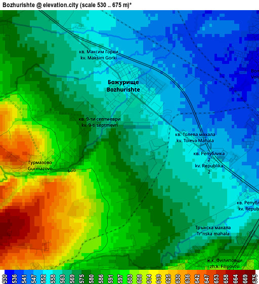
Below is the Elevation map of Bozhurishte, which displays elevation range with different colors. Scale of the first map is from 530 to 675 m (1739 to 2215 ft) with average elevation of 575.7 meters (=1889 ft) [note 1]
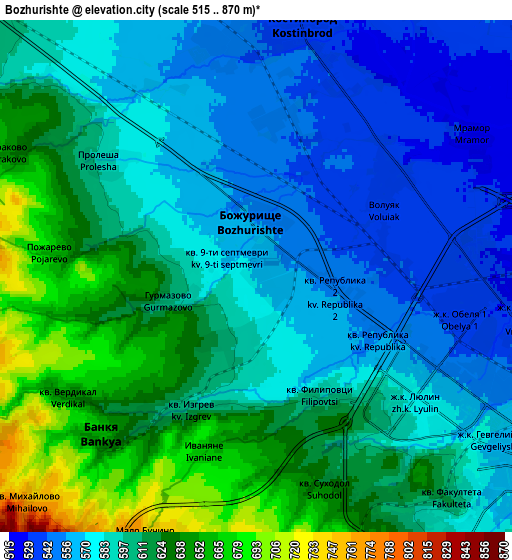
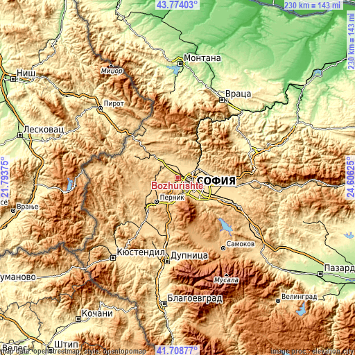
These maps also provides idea of topography and contour of this city, they are displayed at different zoom levels. More info about maps, scale and edge coordinates you can find below images.
| \ | Map #1 | Map #2 | Topo.Map |
| Scale [m] | 530..675 m | 515..870 m | × |
| Scale [ft] | 1739..2215 ft | 1690..2854 ft | × |
| Average | 575.7 m = 1889 ft | 597.1 m = 1959 ft | × |
| Width | 7.18 km = 4.5 mi | 14.35 km = 8.9 mi | 229.6 km = 142.7 mi |
| Height | 7.18 km = 4.5 mi | 14.35 km = 8.9 mi | 229.6 km = 142.7 mi |
| ↑Max Latitude | 42.782262° | 42.814506° | 43.77403° |
| Latitude at center | 42.75° | 42.75° | 42.75° |
| ↓Min Latitude | 42.717722° | 42.685426° | 41.70877° |
| ← Min Longitude | 23.156055° | 23.112109° | 21.79375° |
| Longitude center | 23.2° | 23.2° | 23.2° |
| →Max Longitude | 23.243945° | 23.287891° | 24.60625° |
Nearby cities:
Cities around Bozhurishte sort by population:
• Sofia elevation 562 m
11.7 km,  119°
119°
• Pernik 712 m
21.5 km,  219°
219°
• Radomir 683 m
29.7 km, 220°
• Kostinbrod 534 m
7.5 km,  10°
10°
• Svoge 455 m
27 km,  26°
26°
• Slivnitsa 591 m
17.4 km,  310°
310°
• Elin Pelin 549 m
34 km,  105°
105°
• Godech 699 m
32.1 km,  337°
337°
• Breznik 757 m
23.9 km,  267°
267°
• Dragoman 723 m
29.1 km, 311°
• Buhovo 702 m
30 km,  86°
86°
• Batanovtsi 661 m
26.2 km,  229°
229°
Multilingual:
 En español:
Bozhurishte elevación 568 m.
 En France:
Bozhurishte élévation 568 m.
 Auf Deutsch:
Bozhurishte höhe über dem Meeresspiegel ist 568 m.

Sources and notes:
- [note 1] Map square and city borders are not equal. Map elevation data is calculated only from area inside that square.
- [src 1] Elevation data from geonames database provided with same terms of usage.
- [src 2] The elevation map of Bozhurishte is generated using elevation data from NASA's 3 arcsec (90m) resolution SRTM data.
- [src 3] Base (background) map © OpenStreetMap contributors tiles are generated by Geofabrik and OpenTopoMap.
Copyright & License:
This Bozhurishte Elevation Map is licensed under CC BY-SA. You may reuse any part from this page, if you give a proper credit by linking to this URL:
 More info on terms of use page.